

ORH_wxman
-
Posts
93,092 -
Joined
-
Last visited
Content Type
Profiles
Blogs
Forums
American Weather
Media Demo
Store
Gallery
Everything posted by ORH_wxman
-
March 2022 Obs/Disc: In Like a Lamb, Out Like a Butterfly
ORH_wxman replied to 40/70 Benchmark's topic in New England
Maybe....but that wouldn't explain the obscenely low numbers in the Allagash of Maine. -
March 2022 Obs/Disc: In Like a Lamb, Out Like a Butterfly
ORH_wxman replied to 40/70 Benchmark's topic in New England
I'm starting to think it's just a 2021-2022 snowfall anomaly map using elevation contours attempting to represent the anomaly...it would explain why SE MA and coastal Maine are "higher" than areas to the northwest.....although I don't think they quite achieved what they intended anyway. Places like S VT are solidly below normal for snowfall but still show up high on the map. It's just a terrible and confusing map that doesn't give us much useful information. -
March 2022 Obs/Disc: In Like a Lamb, Out Like a Butterfly
ORH_wxman replied to 40/70 Benchmark's topic in New England
I'm not sold on Thursday....could be 'rhea out of the east. -
March 2022 Obs/Disc: In Like a Lamb, Out Like a Butterfly
ORH_wxman replied to 40/70 Benchmark's topic in New England
It also has my current location down to NW RI higher than the spine of ORH county. Lol Not correct. -
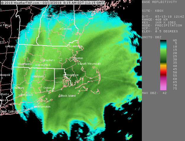
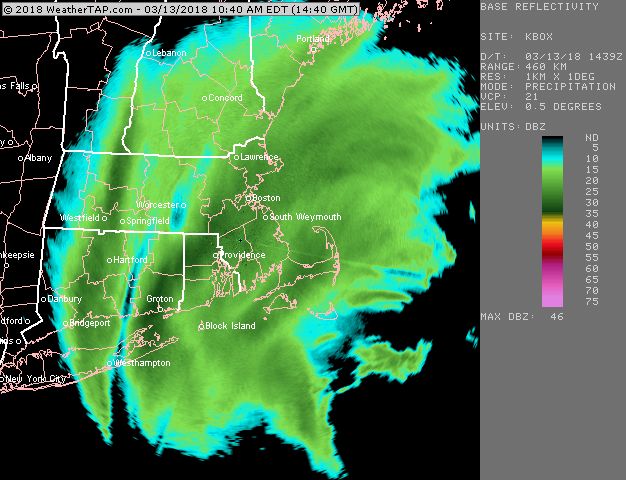
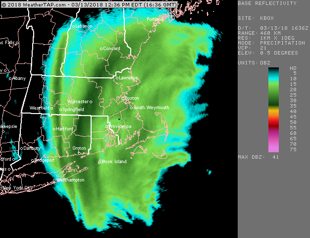
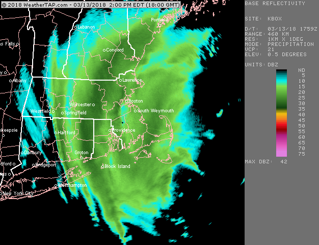
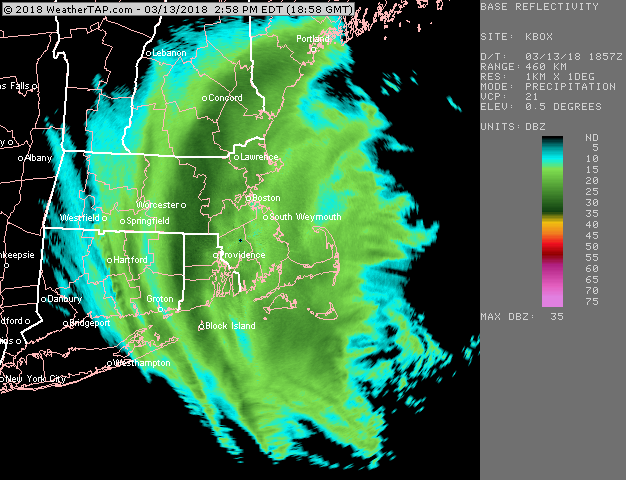
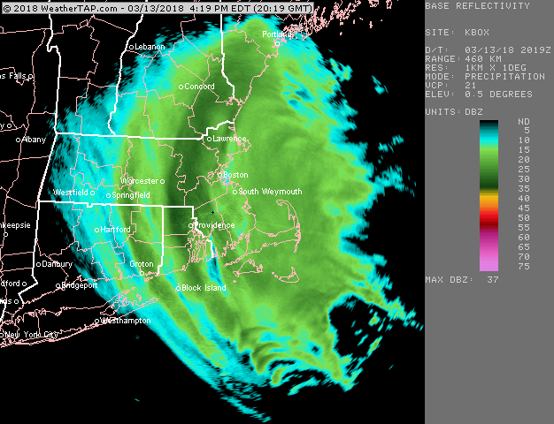
Some good radar shots from that storm too
-
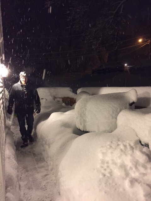
I forgot to post my fav pic from the 3/13/18 storm earlier…this was me on the deck after shoveling. Snow wasn’t done yet at this point either prob picked up another inch or two of fluff
-
March 12 Rain to…more rain? Maybe some snow
ORH_wxman replied to HoarfrostHubb's topic in New England
All joking aside, I’ll vouch that Kevin’s totals are usually pretty good aside from tacking on an extra tenth or three at the end of an event when he needs to close the gap slightly on ORH or Ray. There’s only a couple that I legit questioned: Feb 2013 blizzard he measured a drift and claimed 36” when it was prob more like 30”. Even the NWS tossed it. October 18, 2009 he claimed like 2.5” when the pics were definitely more like 1.0-1.5”. I tried to get him to post a pic on a flat surface with a ruler but he just barked at me and logged off. -
March 2022 Obs/Disc: In Like a Lamb, Out Like a Butterfly
ORH_wxman replied to 40/70 Benchmark's topic in New England
You get plenty of trash in April and May in IJD. It’s better than where I am but you are easily east enough to get in on them fairly frequently. -
March 12 Rain to…more rain? Maybe some snow
ORH_wxman replied to HoarfrostHubb's topic in New England
I had 1.6” in Holliston last night when it started slowing down. I may have had another couple tenths but I didn’t stay up…wind was crazy though when falling asleep. Classic spring day even though it’s cold out struggling to hit freezing. In the sun it’s torched away.
-
March 2022 Obs/Disc: In Like a Lamb, Out Like a Butterfly
ORH_wxman replied to 40/70 Benchmark's topic in New England
He means winter is over. We’re ripe for dogshit easterly flow misery list until mid June some years. I don’t see any frigid winter wx conditions for the remainder of this season though. We lose the cold source in Canada after the next few days. We could still get snow though as bowling ball season happens during the final week of March into early April. The ensmebles are trying to show a potentially favorable period late month….but we know the caveats that come with ensembles. -
That strong NW flow is a brutal wind direction for North Conway and south of the notch. Usually they’ll do well in the synoptic stuff but that’s because synoptic precip also has a east or north wind but not in this storm. So it would make sense that Alex and Phin get crushed while south of the notch struggles.
-
March 12 Rain to…more rain? Maybe some snow
ORH_wxman replied to HoarfrostHubb's topic in New England
Yeah quabbin isn’t big enough. You can get some low level very light snow from quabbin if conditions are perfect but it’s really rare. You only see it out in western ORH county and it’s basically flurries or stray flakes. I don’t know where the streamers came from. I guess lake Champlain could’ve done it on NW or NNW wind and it somehow get reinvigorated because of the upper level support. It was weird but they definitely acted like LES streamers and the snow was similar to what I’d see out in Ithaca off lake Cayuga. They did make for a good wintry scene last night. -
March 12 Rain to…more rain? Maybe some snow
ORH_wxman replied to HoarfrostHubb's topic in New England
Yeah that was funny. Was ripping moderate snow at 29-30F on Mother’s Day. -
That was a great storm here (3/13/18)…measured 24”. That was on top of the 3/7-8/18 paste job…we had a monster pack after the 3/13 storm. Also today is the 29th anniversary of the 1993 superstorm. Hard to believe it’s been almost 30 years. I remember that storm well. I was in 6th grade and the official forecast was for 8-16”….we ended up with 20” despite not being in the CCB/deformation. It was the most ridiculous WCB I’ve been in. It was basically 12 hours of front-end heavy snow. The front end stuff started when the low was still down in the gulf states. It was so expansive.
-
March 12 Rain to…more rain? Maybe some snow
ORH_wxman replied to HoarfrostHubb's topic in New England
Man, just went out to get firewood out back and it’s still pretty nasty out. Wind isn’t as strong as last night but plenty breezy and temps in the low 20s with snow still swirling around and off the roof. Prob the last taste of “true winter” type conditions this season barring one of those rare late season cold storms. (Ala 4/6/16) -
March 12 Rain to…more rain? Maybe some snow
ORH_wxman replied to HoarfrostHubb's topic in New England
The funny part is this will all be a dream in a couple days. Doesn’t feel like it right now though. -
March 12 Rain to…more rain? Maybe some snow
ORH_wxman replied to HoarfrostHubb's topic in New England
Lol. It comes and goes. I’m sure I’ll regress because it’s inevitable. But yeah…like Scott said, we’re not getting that much snow. Maybe 1-2” (spot 3 maybe)…but it’s the nasty wind/snow combo that’s making it such a great feel tonight. Ground blizzard with big gusts and the occasional heavier snow squall. It just feels like deep winter out there tonight. Not a passing spring storm. -
March 12 Rain to…more rain? Maybe some snow
ORH_wxman replied to HoarfrostHubb's topic in New England
This is honestly some of the “worst” winter conditions I’ve seen all year. These gusts are easily passing 40 every few minutes and the blizzard outside. Even when it’s light snow the wind is making an awesome ground blizzard. -
March 12 Rain to…more rain? Maybe some snow
ORH_wxman replied to HoarfrostHubb's topic in New England
The wind is insane in this streamer too. It was already windy but it’s like it got enhanced. Almost like a WINDEX squall. -
March 12 Rain to…more rain? Maybe some snow
ORH_wxman replied to HoarfrostHubb's topic in New England
Yeah once that streamer came overhead all hell broke loose. Still going right now. This is prob like 2” per hour stuff. Perfect LES type dendrites. Wind is packing it though so we won’t be getting 25 to 1 ratios. -
March 12 Rain to…more rain? Maybe some snow
ORH_wxman replied to HoarfrostHubb's topic in New England
Trying to capture it but I keep getting Ginxy cell phone quality pics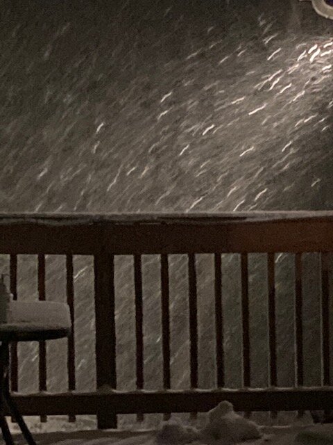
-
March 12 Rain to…more rain? Maybe some snow
ORH_wxman replied to HoarfrostHubb's topic in New England
These are like lake effect dendrites in this. -
March 12 Rain to…more rain? Maybe some snow
ORH_wxman replied to HoarfrostHubb's topic in New England
Ok we have one of those streamers over us in addition to the band, and it’s absolutely pounding. Here’s the still frame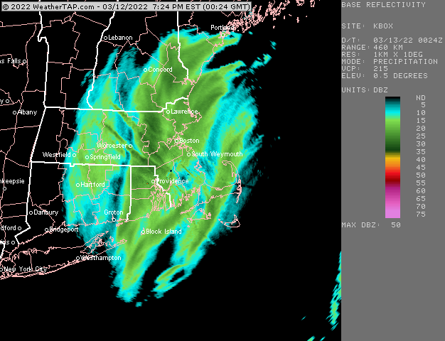
-
March 12 Rain to…more rain? Maybe some snow
ORH_wxman replied to HoarfrostHubb's topic in New England
We’re in the meat of that band now. We’re on the eastern side according to radar but ground truth is a little east. -
March 12 Rain to…more rain? Maybe some snow
ORH_wxman replied to HoarfrostHubb's topic in New England
What are you up to? Looks like you’ll get double digits with the upslope added in over the next 12-24 hours.


