ORH_wxman
-
Posts
93,099 -
Joined
-
Last visited
Content Type
Profiles
Blogs
Forums
American Weather
Media Demo
Store
Gallery
Everything posted by ORH_wxman
-
All that energy loading into the trough and nowhere to go except into a brick wall. That would prob go crazy Monday.
-
Nam is def pretty low with the heights to our northeast. I think the NAM would definitely go more coastal on Monday.
-
Dad laying the smack down.
-
Euro was very good for trying to squeeze out a few inches later Monday into Monday night. Keeps that low level circulation south of us.
-
One of the luxuries of having a crazy frigid antecedent airmass is small moves don’t really change anything all that much. We can handle some decent wiggle room with these temp profiles.
-
Ukie was juiced. Kept that onshore flow into Monday evening to add a few additional inches.
-
January 2026 regional war/obs/disco thread
ORH_wxman replied to Baroclinic Zone's topic in New England
I’ve been thinking about dropping lurker status on Twitter (I have zero posts in my history) and just going Arnold in Commando on all the awful hypsters on there. I think 10-15 years ago I totally would but now it’s probably not worth taking up the time. -
January 2026 regional war/obs/disco thread
ORH_wxman replied to Baroclinic Zone's topic in New England
Super bomb. A lot of mets used super bomb as slang for a storm that dropped more than 2mb per hour for extended period of time. -
I think you are thinking of 2/13/14….the 2/5/14 storm was much more of a SWFE with a latitude gradient south of SNE.
-
The DGZ is essentially from the sfc to 700mb on Monday so anything low level is gonna be quite efficient. The question is just how much lift can we generate in the low levels. Stronger onshore flow will certainly help as you push that marine boundary layer into the arctic dome…that alone will generate decent low level lift. But that’s why getting a decent secondary staying to our south as long as possible is key. Once it reaches our latitude, winds in the BL will be less and less onshore.
-
January 2026 regional war/obs/disco thread
ORH_wxman replied to Baroclinic Zone's topic in New England
Lots of barking on 12z guidance so far about next weekend. Both GEM and GFS. GEM is trying for Thursday while GFS is Saturday. -
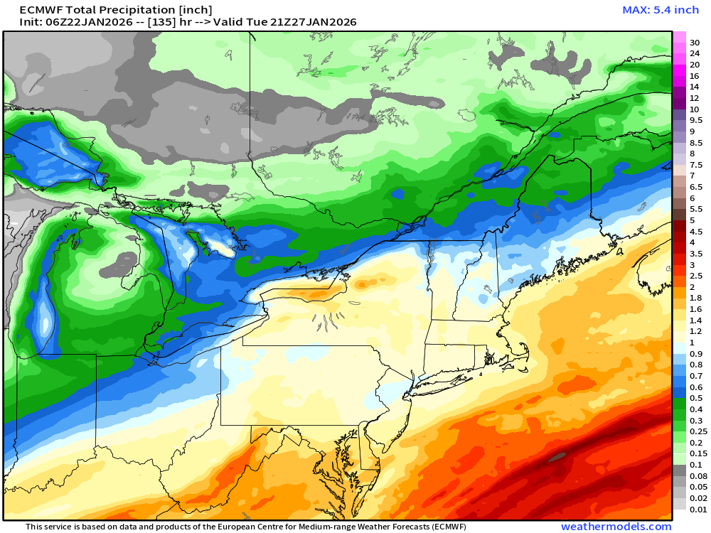
I think you’ll need to tack on 6”+ after the initial overrunning thump to get 20” amounts. That’s possible but it requires some form of a CCB even if it’s mostly lower level…all that onshore flow from 850 and below. Guidance disagrees on the extent of that type of setup early Monday.
-
Prob a pretty decent call right now based on most guidance. You can almost broadbrush 10-16 across SNE. Maybe go slightly more conservative on the islands. There also might be a stripe of slightly higher amounts if there’s good OES enhancement and CF enhancement in a few spots, but I wouldn’t want to forecast explicitly over 16” for any one spot.
-
Heights have been showing up a bit lower in Quebec on the 12z runs so far. The stuff out west is still amped, so it’s actually a good combo for a lot of us because it runs into an even more stout brick wall than before which will increase QPF
-
RGEM looks a touch suppressed too with the heights to our north. Everything out west looks great though.
-
Maybe 1 in 3? I’d prob forecast 10-15” at the moment….
-
This reminds of the scene on the plane in the movie Con Air when Steve Buchemi’s character is commenting on another convict…he says, “That guy is so angry that moments of levity actually cause him pain, gives him headaches. Happiness for that man hurts.”
-
Slightly more confluence too so you’re gonna be absolutely slamming some big fronto.
-
What’s with the obsession with the mixing talk? In order to get mixing up into this airmass, you’re gonna charge Mother Nature a fee of about 10-15” of snow. It’s just gonna take so much forcing.
-
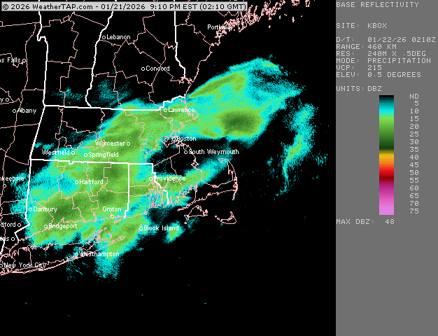
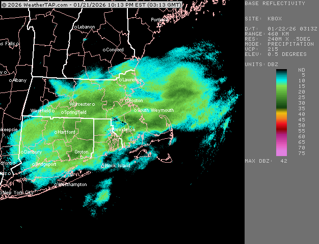
About an inch here.
-
06z op Euro looks pretty nice
-
Looks like BOS is getting the ol’ 7-10 split
-
Looks like the GFS will not whiff on the phase like 18z did.
-
Just training over here right now.

-
Now we’re rocking. This is pounding.