ORH_wxman
-
Posts
93,099 -
Joined
-
Last visited
Content Type
Profiles
Blogs
Forums
American Weather
Media Demo
Store
Gallery
Everything posted by ORH_wxman
-
25.4” in April ‘97. There is a zero percent chance that gets broken in this storm.
-
Looks like you snuck a government map in there on the left side, middle row. We also lost most of eastern MA on the middle map. ORH hills gonna get crushed with onshore flow.
-
Imagine how sharp the trend in National average temperature would drop.
-
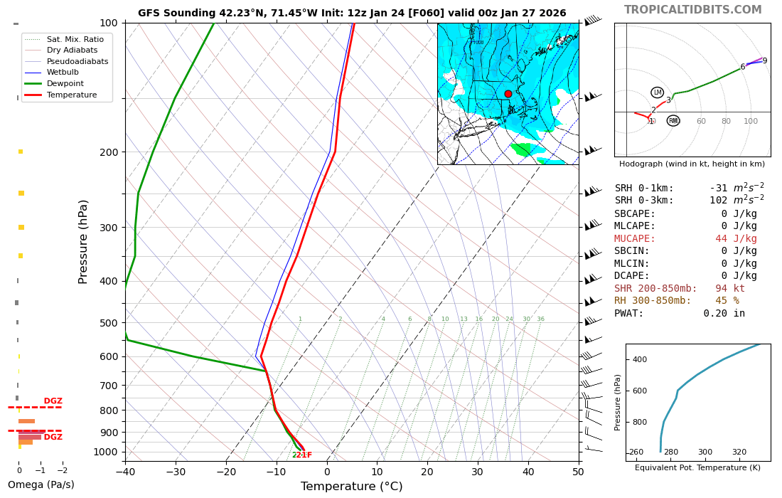
I find clown maps in general to be very misleading. They are ok for kind of gauging the max zone or distribution of snowfall but even in those cases you have to be careful…esp when it’s very very cold like this storm. It tries to spit out like 20+ to 1 ratios way up north where arctic sand might be falling. They are kind of fun to look at, but be aware of your audience, lol. Those of us who are on here all the time and look at them all the time know their shortcomings, but many irregular posters who jump on during larger events might not. The ramping up of QPF in this system is a very good sign though for the higher amounts. A lot of times we see some decent haircuts as we get closer if it’s not a big coastal…but not this time. This one looks like the real deal.
-
The kuchera maps will be correct somewhere, but not because they are uniquely skilled…it will just happen to guess the ratio correctly wherever good snow growth overlaps with the deep layer cold the longest. Outside of that zone it will probably wildly overestimate.
-
Rgem and GGEM never ran, lol. Can always count on the Canadians
-
Scooter jack?
-
-
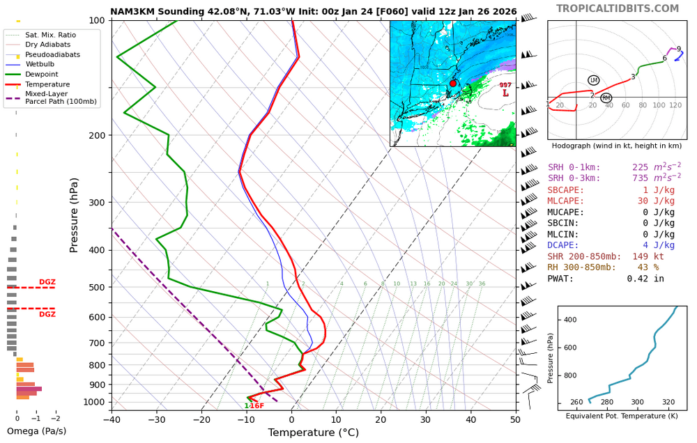
Drop a couple tenths on Monday with those soundings. You could grab 3-5” of fluff with that. I hope it’s right but it’s not every model. Icon and NAM were less. Maybe a tenth at most.
-
Some nice goodies on Monday on gfs. That’s high ratio fluff looking at soundings.

-
Prob not all day. Could be nothing for a few hours in the morning while we wait for the vortmax to roll through. If we keep the low level circulation further south then I could see steadier stuff most of the day. But the latest trends want to tick it a bit northeast.
-
I’d still keep it 12-18 for here because I’m skeptical of 20+ if we aren’t getting more than an inch or two Monday. Our biggest thumps are typically in the 14-15” range (ala Mar 2017, Feb 5, 2014, etc)….if we messenger shuffle the low level circulations a bit over the next 24 hours, then maybe I’d consider going a little higher since that would make Monday look better. But the big snows are basically 10 hours…like 2pm-midnight. A little earlier for your area. So it’s hard to go too crazy given those facts.
-
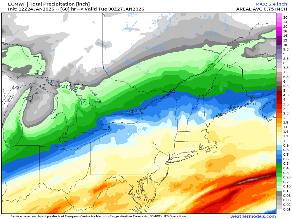
A lot of these recent runs are showing 1.5”+ QPF here….def getting more high end. Still think prob 12-18 but some 20 burgers aren’t out of question.
-
Wow I hope the NAM is right. I’d have to up my forecast here to 15-20” easily. That’s a monster QPF bomb.
-
It depends where. They are inflated because of the lower level cold. They will be wayyyyy too high on the northern side where temps are hanging near 0F and 5F. QPF maps are the way to go in all snow events.
-
Looked like the thump was slightly better but Monday was more meh on that run
-
Narcan maps being bullish is always a good sign.
-
GFS got a bit juicer in SNE.
-
Looks like they decided not to send Reggie to the plate tonight.
-
Might get some small cotton balls with that setup.
-
Yeah it exited flatter that run. It was slightly more amped than 18z out west but the northern stream pressed late and had it exit pretty flat which helps Monday.
-
January 2026 regional war/obs/disco thread
ORH_wxman replied to Baroclinic Zone's topic in New England
I had 17” and im maybe 15 miles north of Cumberland. -
Looked slightly flatter than 18z. But close.
-
Yep this is the attitude to have. If you had offered anyone a 10” floor 3 days ago, they’d take it and run.
-
Yeah, the biggest reason this is higher end despite being a SWFE is the airmass and amount of moisture involved. You try and rip that type of gulf moisture up over the top of an arctic airmass this cold, you're going to get fireworks....and it's also kind of an ideal angle with the broad trough...so the duration is decent for a SWFE....instead of like 6 hours and out, we're more like 10-12 hours before the upper midlevels start to dryslot. You can also throw in some local enhancers with this airmass like OES and a CF....the CF helped you in a system like 12/16/07 and it might help you again. So we could easily see widespread 10-16/12-18 from that. I think a lot of the 20"+ talk is overhyped at the moment, especially since Monday is looking less onshore flow if this ticks north....but there is still the chance someone could grab 20 if we trend that Monday position a bit further south and prolong onshore flow.