ORH_wxman
-
Posts
93,092 -
Joined
-
Last visited
Content Type
Profiles
Blogs
Forums
American Weather
Media Demo
Store
Gallery
Everything posted by ORH_wxman
-
The last hurrah? Putting all the eggs in the Tuesday 3/14 basket
ORH_wxman replied to Ginx snewx's topic in New England
Everyone’s nervous before the euro comes out. Even Wolfie. -
The last hurrah? Putting all the eggs in the Tuesday 3/14 basket
ORH_wxman replied to Ginx snewx's topic in New England
You went from a euro-skeptic to a euro-truther in about 2 days. -
The last hurrah? Putting all the eggs in the Tuesday 3/14 basket
ORH_wxman replied to Ginx snewx's topic in New England
This is excellent. Something MaineJayhawk would come up with. -
The last hurrah? Putting all the eggs in the Tuesday 3/14 basket
ORH_wxman replied to Ginx snewx's topic in New England
No, but your area is still looking pretty good. -
The last hurrah? Putting all the eggs in the Tuesday 3/14 basket
ORH_wxman replied to Ginx snewx's topic in New England
Yeah I have a hard time seeing how ORH gets less than a foot unless this thing unravels with a strong trend toward primary being dominant…which guidance has trended away from in the past 24-36 hours. Toughest area in MA is prob like Ray and your area near ASH down 495 and then towards 128 and interior SE MA. I feel reasonably confident at a big storm for the 495 crowd but there’s enough lingering doubt that we get a sloppy 3-6” instead of double digits that I want to see another model run. A good euro run would increase confidence because the euro has been pretty bullish and relatively consistent. -
The last hurrah? Putting all the eggs in the Tuesday 3/14 basket
ORH_wxman replied to Ginx snewx's topic in New England
The Ukie has a pretty bad warm bias right at the sfc. -
The last hurrah? Putting all the eggs in the Tuesday 3/14 basket
ORH_wxman replied to Ginx snewx's topic in New England
That is a great product….but those are only useful if the model is accurate. I wouldn’t trust the 51 hour NAM at this point. They’ll be better to use tomorrow when hopefully we have more model consensus. -
The last hurrah? Putting all the eggs in the Tuesday 3/14 basket
ORH_wxman replied to Ginx snewx's topic in New England
Yeah highest terrain maybe. If we start seeing more NAM-esque soundings, then higher ratios become more likely. But we have a lot of solutions that are pretty warm in the BL still. -
The last hurrah? Putting all the eggs in the Tuesday 3/14 basket
ORH_wxman replied to Ginx snewx's topic in New England
SREFs pretty much useless until like 24h out..which makes them useless overall these days. They used to be ok on winter storms when they had the ETA members included. -
The last hurrah? Putting all the eggs in the Tuesday 3/14 basket
ORH_wxman replied to Ginx snewx's topic in New England
Yes maybe. That doesn’t change my point though. NAM was pretty cold but people should stop posting 10 to 1 unless we’re doing it with caveats. -
The last hurrah? Putting all the eggs in the Tuesday 3/14 basket
ORH_wxman replied to Ginx snewx's topic in New England
Stop using 10 to 1 maps -
The last hurrah? Putting all the eggs in the Tuesday 3/14 basket
ORH_wxman replied to Ginx snewx's topic in New England
No but it’s certainly a possible solution. -
The last hurrah? Putting all the eggs in the Tuesday 3/14 basket
ORH_wxman replied to Ginx snewx's topic in New England
NAM is like classic KU with all the features for SNE. -
The last hurrah? Putting all the eggs in the Tuesday 3/14 basket
ORH_wxman replied to Ginx snewx's topic in New England
For now we sell, but it’s silly to completely ignore. There’s enough guidance that shows exceptional rates and the dynamical support aloft. We’ll see today if more guidance trends toward that or toward more mundane. -
The last hurrah? Putting all the eggs in the Tuesday 3/14 basket
ORH_wxman replied to Ginx snewx's topic in New England
Agree with what? Caution flags there? Yeah I would. Even here I still have caution flags…I think we’re looking pretty good for warning snows, but there’s a big difference between 6-8” and 18”. I think for places like ORH up to Hubbdave, it’s time to chuck ‘em, but south and east still have more questions to iron out. -
The last hurrah? Putting all the eggs in the Tuesday 3/14 basket
ORH_wxman replied to Ginx snewx's topic in New England
Id prob weight the NAM like 10% right now. It gets more weight once we’re down to about 36h. -
The last hurrah? Putting all the eggs in the Tuesday 3/14 basket
ORH_wxman replied to Ginx snewx's topic in New England
There’s potential in his hood for epic blizzard conditions. But there’s a lot of temp issues too to overcome there. -
The last hurrah? Putting all the eggs in the Tuesday 3/14 basket
ORH_wxman replied to Ginx snewx's topic in New England
We had exceptional damage here in the Mar 7-8, 2018 storm which was like a foot of grease. So it’s definitely going to a problem with power issues if we get even 8-12” -
The last hurrah? Putting all the eggs in the Tuesday 3/14 basket
ORH_wxman replied to Ginx snewx's topic in New England
When I looped h5 on the 06z euro, I def expected heavier QPF than what it showed. But it was a step down from 00z. It’s going to be a significant storm, but the difference between a HECS type blizzard and a fairly heavy late season snow event (but nothing earth shattering) is going to come down to if we have those truly exceptional rates for hours on end. -
The last hurrah? Putting all the eggs in the Tuesday 3/14 basket
ORH_wxman replied to Ginx snewx's topic in New England
Yeah that was kind of weak sauce. I think there needed to be more southern stream. But who knows. It just didn’t want to pop that low to another level like most other guidance. -
The last hurrah? Putting all the eggs in the Tuesday 3/14 basket
ORH_wxman replied to Ginx snewx's topic in New England
Can’t believe it’s been 3 decades since that storm. -
The last hurrah? Putting all the eggs in the Tuesday 3/14 basket
ORH_wxman replied to Ginx snewx's topic in New England
Yeah there are some similarities aloft. But Feb 2013 had a monster high to the north and this one doesn’t. -
The last hurrah? Putting all the eggs in the Tuesday 3/14 basket
ORH_wxman replied to Ginx snewx's topic in New England
Also going to get a death band as the fronto prob goes nuts while it’s moving NNW -
The last hurrah? Putting all the eggs in the Tuesday 3/14 basket
ORH_wxman replied to Ginx snewx's topic in New England
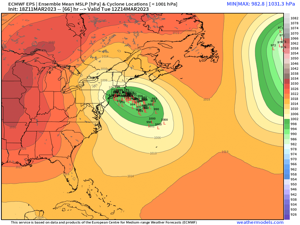
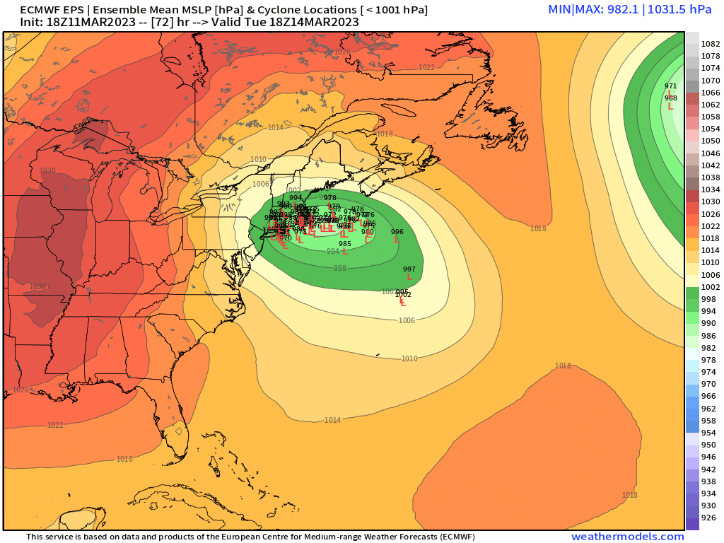
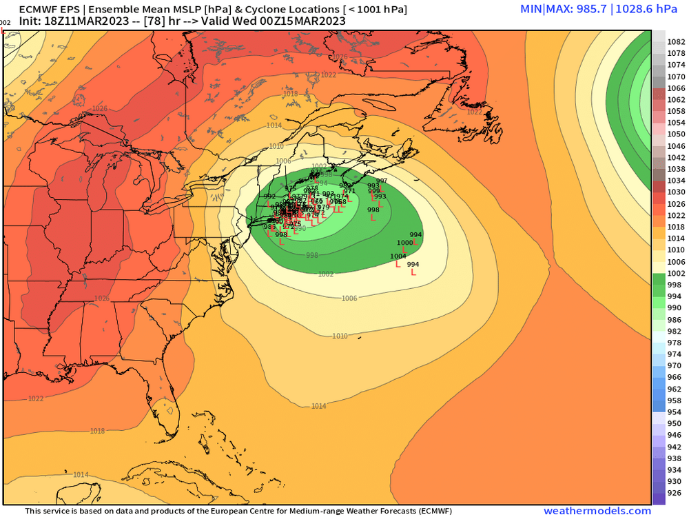
Lot of seaward members on EPS taking a wide turn. But they do start consolidating closer to the cape on the next couple frames.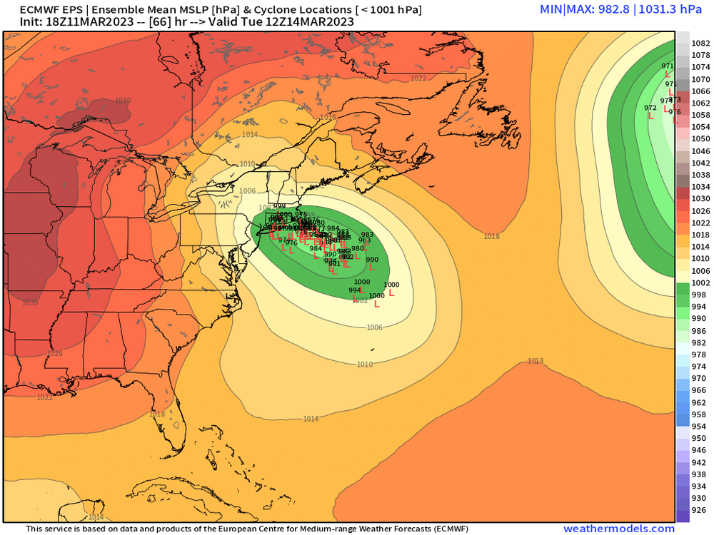

-
The last hurrah? Putting all the eggs in the Tuesday 3/14 basket
ORH_wxman replied to Ginx snewx's topic in New England
Yes once you see those 925s collapse in the CCB, the profile gets easily cold enough for snow at least away from the water. I do think places in CT that are getting a lot of WCB precip prior to the CCB need to look at the soundings very carefully.