ORH_wxman
-
Posts
93,092 -
Joined
-
Last visited
Content Type
Profiles
Blogs
Forums
American Weather
Media Demo
Store
Gallery
Everything posted by ORH_wxman
-

-
Yeah...I mean I'm definitely leery of the strength of the El Nino causing us problems in the snow department, but I am not hugging Super Nino climo at this point for 3 main reasons: 1. We're not even sure this will qualify as a Super Nino (looking increasingly like it might fall short) 2. Our sample in Super Ninos is very small 3. Even if it does technically qualify as a Super Nino, will the warming in the western PAC regions affect it's behavior. (e.g. MEI looks much weaker than a typical Super Nino, and this suggests that the atmosphere may not behave like a typical Super event) The key will be monitoring the strength of the Aleutian low and it's placement....in the typical blowtorch Super Ninos, the Aleutian low set up more in the GOA (Gulf of Alaska) rather than further west south of the Aleutians and it was much bigger/stronger than other El Nino events. Becuase of this, you just see this firehose of Pacific air slamming into the CONUS and not allowing much cross-polar flow or even domestic cold from AK/NW Canada to become the dominant source of our airmasses.
-
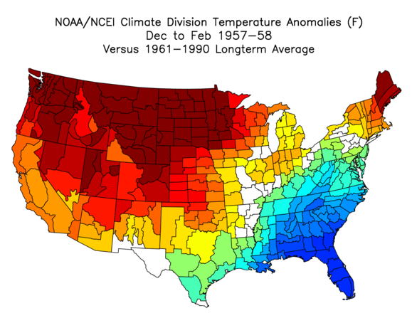
'65-'66 was much colder in the plains and west than '57-'58 was, but yeah, it's not a terrible match east of the MS River. Above average from Great Lakes to New England but below average from about DC southward. It was a decent snow winter for SNE on the whole, but not a great one. Slightly above average for most places here....maybe more like near average for PVD/far southeast areas.
-
And I'll add that "Soft -PNA" periods could still be very productive for snow if we're getting a favorable arctic. What I mean by "Soft" is that it's not a ridiculous longwave trough swinging down into Baja Cali dusting the Hollywood sign with snow. Usually just some weakness in the western ridge or a shallow trough over the PAC NW....something we've seen a bunch of times before during cold/snowy periods as long as the arctic was cooperating. I'd expect plenty of troughs to swing through the southwest this winter, but probably more due to split flow (with STJ going strong) and not because the polar jet stream was making a surgical strike from Barrow, AK to Palm Springs.
-
I'd be shocked if we don't have many solid +PNA periods. I don't expect a standing wave +PNA ridge like we had for 8+ weeks in late Jan-Mar 2015, but this El Nino is too strong not to force some decent Aleutian Low/+PNA periods. Whether they are fruitful will probably come down to how hostile the arctic is or not....if we get a shit arctic (esp near the EPO region), then it's probably just another flavor of dsogshit....but a half-decent arctic would probably produce some real fun periods.
-
It's kind of a '57-'58-esque temp pattern...and that was a big interior winter. Coast did ok too, but the real goods were interior.
-
Yeah over the interior of SNE, '95-96 is still #1. In fact, in ORH, '14-'15 isn't even #2, it narrowly loses to '92-'93. Regardless, if we can get some good periods of +PNA mixed with a favorable polar domain, then we should have plenty of chances this winter. Hell, even a -PNA/-AO would be ok provided we're not first digging the PNA trough into S CA and Baja first before it swings eastward like December last year.
-
Yeah I loved the old hour/storm total/snow depth obs at the end of the METARs
-
Yeah the coast got decent snow on the front end of that post-Xmas storm....it just got matted down with a lot of rain when it flipped while it stayed snow around 128 and west. But that's still a good December on the coast.
-
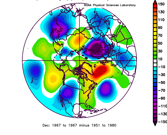
Doesn't look quite as bad as some other recycled garbage patterns because you have a pretty strong ridge poking up to the GOA....so even though the EPO isn't strongly negative, you have cross polar flow at least coming from Bering/AK region rather than the source region being the Pacific. The pattern actually looks really similar to Dec 1967...that month was near normal temps, maybe slightly above (in the 1967 context with '51-'80 normals)....but it had some decent snow chances, although you'd probably take a toaster bath in the 12/28/67 storm which was a classic Rt 128 storm where BOS and the south shore struggled while metrowest cleaned up.
-
El Nino (particularly strong El Ninos) produces a spike in global mean sfc temps because more of the OHC is pushed to the sfc in El Nino.
-
Yeah I commented that it looked like there was decent cold getting into the CONUS for Dec even if it was mostly west of us....but we know that can bleed over the top at times and setup a gradient storm or two. The ideal scenario is for December to act more Nina-ish and then we flip to classic Jan/Feb El Nino.
-
Thanks....yeah if we got that type of -EPO in Dec, then we're prob off to the races. That's a Dec '09 look...... though with a west-based -NAO that is more tame than the 2009 steroids version. But that would still be an excellent winter pattern.
-
What's the track record on that 2 months out? I can't imagine it's great.
-
That's a great look for Jan/Feb but somewhat ugly for Dec....though at least in Dec you still have decent cold flowing down into the CONUS and not a GOA monster low torching everything, so you'd hope you could sneak in some chances.
-
I don't doubt that is true. There were also studies showing we were getting more frequent winter -AO "warm arctic/cold continent" patterns in the 2000s/early 2010s compared to the previous 2-3 decades, but that trend obviously did not sustain. Maybe the MJO trend will...my default is to be skeptical of regional trends sustaining which is where the literature struggles the most.
-
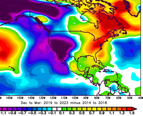
Def trended warmer for the east and gulf coast, but probably colder for the rest of the majority of the country west of the Apps. The pattern actually looks like a colder version of the 2012-13 where that H5 minimum anomaly is out in the rockies....better AK ridging than '12-'13.
-
The last 10-15 years got my head spinning on a lot of the attribution studies....they often feel like "flavor of the month"....trying to explain a multi-year pattern as something more permanent like those other examples I gave above. They haven't managed to stand the test of time so far. I'm not going to claim that the northeast cannot warm a lot faster than everywhere else for a long period of time, but it certainly would be pretty unusual for that to happen at our middling latitude. That type of consistent (say, multiple decades) higher end warming trend has been almost exclusively relegated to the high latitudes and lower latitude trends have typically fluctuated a lot more.
-
Maybe? Are we sure that's the primary culprit? And if it is, is it going to continue? Do we need to update CC models to show that the plains and west are going to be colder than originally expected moving forward while the east is going to be warmer? Are we sure another Pacific blob isn't going to show up like 2013-2015 or more sea ice-induced monster -AO patterns? I dunno....they are plausible, but color me skeptical on regional enhancements being more than transitory outside of more robust empirical evidence (I'd put arctic amplification in that category...far more robust evidence supporting it).
-
Octorcher or Roctober 2023 Discussion Thread
ORH_wxman replied to Damage In Tolland's topic in New England
Don't think I've used the AC since that heat wave in early Sept.....it was pretty warm yesterday, but I think the house just doesn't warm up as quick with the weaker sun. We have a lot of trees around too, so the lower sun angle makes it shadier in the shoulder seasons. -
Considerably weaker arctic blocking on the new run and much weaker Aleutian low.
-
Octorcher or Roctober 2023 Discussion Thread
ORH_wxman replied to Damage In Tolland's topic in New England
Yeah I ran the numbers a few years ago and the mean winter for ORH with measurable snow in October was basically the same as the regular mean. I think since I did those numbers, we had the October 2020 snow event, but that winter dumped like 77” of snow at ORH so it certainly didn’t bring it down…if anything, it prob pushed the number a small tick higher. -
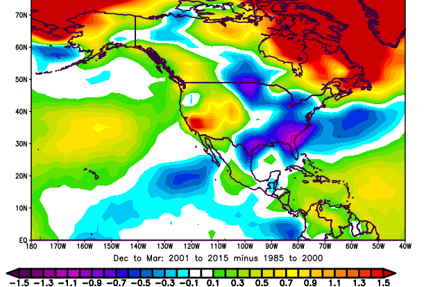
Yes, it would make them more common. That's going to be true by definition in a warmer world....in a previous torch where it didn't quite all melt out to Canada, now it might. But I think people should be aware of the statistics and probability to competently discuss it. I often come across even supposedly vetted news articles that claim certain weather events are "unprecedented" only to find something extremely similar in the past....or worse, something that even eclipsed their example. CC makes anything warmer more likely....the "loaded dice" description is pretty accurate IMHO....but the question is by how much and when we are discussing non-temperature weather events such as large storms, nor'easters, droughts, etc, how much weight is CC on the attribution list? Sometimes the answer is zero or at least statistically insignificant. That's where some of our previous discussions went when talking about the anomalous warm winters we've seen since 2017-18...a lot of people knee-jerkingly blamed CC as the primary culprit, but it's extremely unlikely that it was. It's part of the reason, but a few seasons of mostly warm winters is more likely caused by natural variability with CC acting as a tail wind. The evidence for this is that other regions of the country and continent have become significantly colder in those same seasons....here are the winters since '17-18 versus the previous 5. We can repeat this exercise too for previous periods like when the northern plains down to the SE US were warming way more rapidly in the late 1980s/1990s and then they became colder in the 2000s/early 2010s. The longterm average increases but it's not a smooth ride.
-
Was that the March storm this year?
-
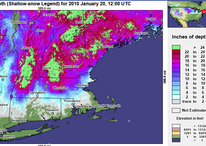
This one was the cause of an epic Kevin meltdown....MLK weekend massacre 2010