ORH_wxman
-
Posts
93,092 -
Joined
-
Last visited
Content Type
Profiles
Blogs
Forums
American Weather
Media Demo
Store
Gallery
Everything posted by ORH_wxman
-
12/2 was the most popular pick so that date should prob stick...I'm going to be in Maine this weekend, so I won't be there unfortunately, but I will definitely try and make a local Clarke's pre-Xmas GTG if a few of us are interested in that. I am in Boston a few days a week now, so it wouldn't be very hard for me to come on over after work.
-
I think GaWX was using a true 2.0....not rounded. Since 1965-66 with its rounded 2.0 trimonthly peak is usually classified as "strong" and not "super" because it had an unrounded trimonthly avg below 2.0 (something like 1.97 IIRC).
-
There's another weaker signal for Dec 7-8 too....I think the Dec 4-6 one is prob too warm for us though...NNE might be different. Some of it will depend on how the NAO block shakes out....that could still correct the whole system south since the block will influence any potential 50/50 low and confluence in SE Canada.
-
That would be more toward climo anyway in El Nino....December is often a lost month, but I do like that we're seemingly in the game this month for some threats even if it's not Dec 1995.
-
Early Dec never looked great....esp south of us....there were some runs that looked decent for New England though because of the stout NAO block, but IMHO the best chances are NNE prior to about Dec 6-7ish. Biggest change on the ensembles is the EPS has the MJO going decently into phase 4 now whereas most other guidance is bringing it back into the COD prior to that....so the EPS doesn't look that good for Dec 5-11ish like it did previously while the GEFS/GEPS still look pretty favorable. I don't know if the EPS is correct since it's kind of an outlier....we'll see what it does today. The good news is that beyond that hasn't really changed much....it looks like we still loop back toward phase 8 just after mid-month so hopefully we get a nice run into the holidays and beyond.
-
Oh yeah that’s really cheap. Lol. I had initially thought it was they didn’t have a 1” event. Still a terrible stretch for them regardless, but those dual 0.9” numbers make that stat kind of dumb.
-
You were correct that it lasted more than one day…it just happened to be almost all of 12/11-12/12 so we can mostly leave 12/10 and 12/13 out of it for up here anyway. Further south, it was a bigger deal on 12/10
-
It was a 40 hour storm roughly. From maybe dawn hours on Friday 12/11 to late Saturday evening 12/12…some areas may have started slightly earlier or ended a little later but 99% of the impactful parts of the storm were on 12/11 and 12/12.
-
Nitpick but it was 12/11-12/12, 1992
-
Irony is in that ENSO thread where bluewave was showing how more recent blocks were south (therefore not helping us as much), we need this upcoming block to be a little more south to ideally keep us more in the snow game during the hostile PAC phase. A lot of these runs have it too far north and east for us. But it’s probably in a very good spot once the PAC goes a little less hostile. It also starts migrating SW with time as it retrogrades.
-
PAC trended worse in that first week of Dec than previous runs…it was already a hostile PAC but it went even more hostile. You have a solidly +EPO and a deep western trough with it. This isn’t a massive shock since you have MJO trying to force its way into the bad phases…it never reaches there in high amplitude but even weak bad phase is going to be working against us. The fact anyone in New England still has a shot at some snow during that is all due to the NAO block. PAC def becomes less hostile though after the 4th/5th or so.
-
I’ll admit Mar 2014 was a bitter pill to swallow. Threat after threat missed in all directions with like a -8 month.
-
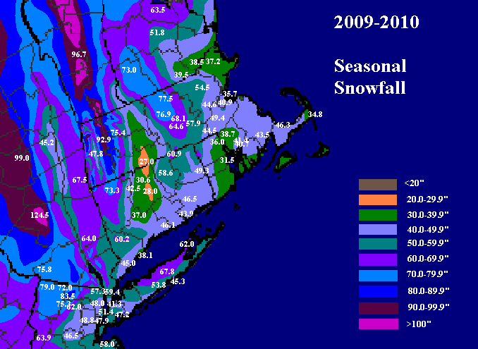
‘13-14 was solidly above average in our area for snow. It wasn’t a blockbuster but Boston had nearly 60” that winter. ORH was 85ish.
-
That was a frigid winter…esp down there. And DC had like 5 or 6 decent events that winter. Not a one storm wonder year. Long winter too…iirc DC got smoked St Pattie’s day…that’s really late for them.
-
Errors theoretically should cancel out if they are random…some will be too warm and some too cold. There’s so many asos stations that we have a very good idea of larger scale temperature trends. But a corrupted ASOS at ORH for example is a major problem if we want to analyze temperature trends at that one spot. We’ll see a spurious jump in temps starting around 2020 that isn’t real.
-
ORH has been running too warm for 3 years now. PVD more recently has been running too cold.
-
First week of December might favor that with the semi-marginal airmasses. It would normally be a torch pattern but the NAO block keeps it marginal instead. Then the PAC improves after that.
-
The key word is “average”. Why would you just reduce predictions to a mean of a decade? That’s hideous and doesn’t tell you anything about an individual month in an individual year.
-
Yeah the mid-Atlantic didn’t really get much snow until the very end of January. We actually had a nice storm in early January in New England with a retrograde job that gave widespread 6-10” type totals with some much higher jackpots in NNE with upslope/lake Champlain enhancement. Then we had the MLK storm that was pretty solid over interior MA. Honestly, by the end of January, it actually hadn’t been a bad winter at all over interior SNE. Things turned for the worse in February though from a frustration standpoint. Missing KU after KU. 2 suppressed and one retrograding right on top of us.
-
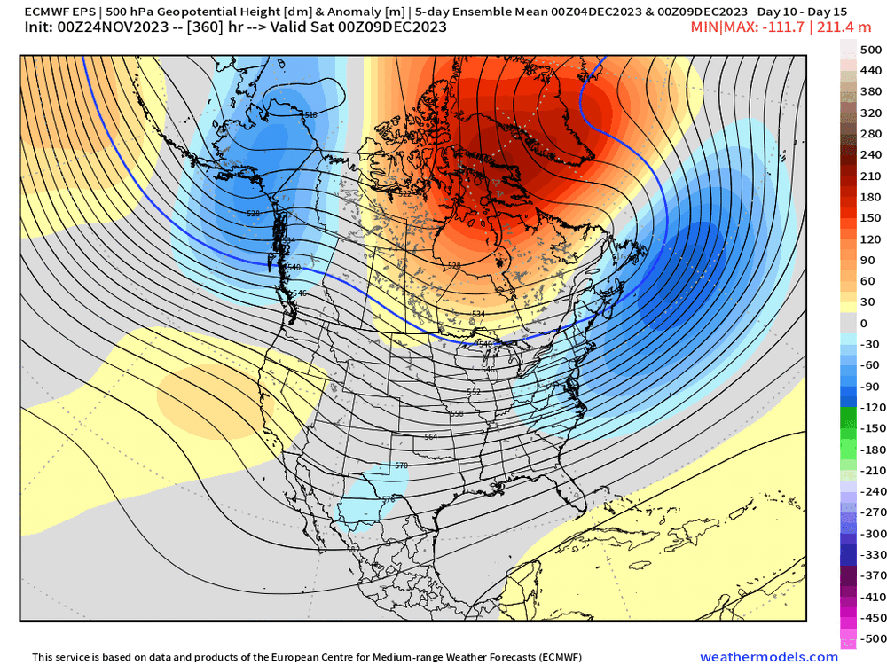
Yeah this looks much better…esp after about the 3rd or 4th of December. We’re actually popping a bit of western ridging on all ensemble guidance after that time. We know the NAO blocking is extremely likely at this point given that the onset of it is now inside a week, just want to see that improvement on the PAC side get closer.
-
Promising trends but I’d wait until closer and actual threats emerge to expect big things. But at least it’s not a pattern that looks like garbage.
-
EPS definitely showed more western ridging today....he's the Dec 3rd-8th five day mean 00z vs 12z run You can see the western ridging increased on the 12z run but also the lower heights near AK were more retrograded toward the Aleutians on the 12z run which helps pop that western ridging. So this may be a period to watch if we can keep this look as we get closer.
-
GEFS show you a less hostile N PAC too...it retrogrades the -PNA trough between D7 and D10 back to the GOA (and even nearly to the more classic Aleutian low position) to pop a bit of western ridging. That helps in trying to sneak a coastal threat into the mix the firts half of the month, I'd like to see the EPS do that too...it showed a little western ridging, but not nearly as much as the GEFS on the 00z suite. The Euro suite on the weeklies waits more until that 3rd week of the month to show more western ridging.
-
I don't think his progression is unreasonable....though I probably wouldn't speculate on severe cold in January at this point. But it def looks to become more favorable toward mid-December. But that definitely doesn't mean we cannot score an event in the first 10 days....with the NAO blocking like that, you always have to watch. GEFS looked pretty nice actually just beyond 12/5 with a solid +PNA to go with the NAO blocking....Euro/EPS wasn't quite as enthusiastic aboutt he PNA but still not bad at all.