ORH_wxman
-
Posts
93,099 -
Joined
-
Last visited
Content Type
Profiles
Blogs
Forums
American Weather
Media Demo
Store
Gallery
Everything posted by ORH_wxman
-
I mean, you dont need to rely on it for warning criteria there imho. I think you’re already in the 6-8” range from the initial thump….the Kraft finish is what will decide whether you get 8-10 or 12-16. If it’s kind of disorganized and too late, you prob only add a couple inches of powder. But if it cranks for 4-6 hours then you’re adding another 6”
-
Ran the 18z euro from my basement. Jackpot from 495 region here to ORH up to Ray’s hood
-
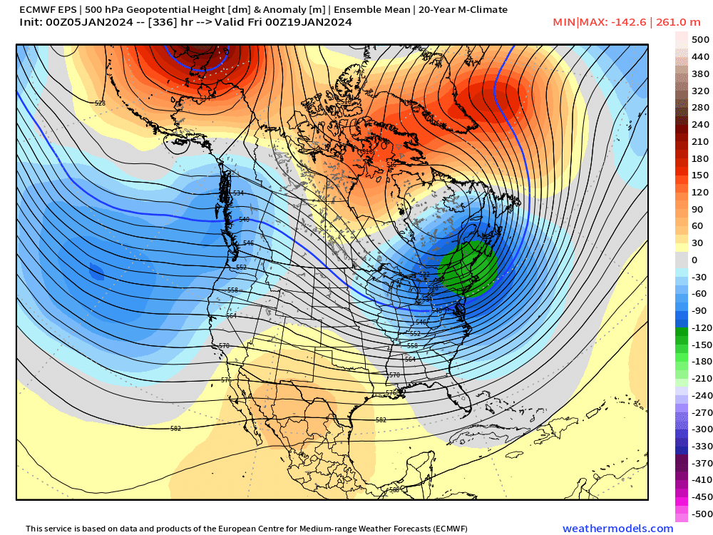
This is just an ensemble mean. So I think you’d have plenty of members that have some oscillations in the severity of the PV press and the blocking itself. But my biggest worry is still too much PV loaded into the western half of Canada…id prefer a good chunk of it to break off and park itself in eastern Canada so we can have a good source of cold and confluence.
-
This run is mainly NNE. But there’s a chance it could still produce in SNE but it needs more work. 12z Euro actually had SNE in some front end snow.
-
North shore could get 3-6 just from Sunday PM from CCB when temps are crashing. Big bust potential up there.
-
It’s really just at the sfc. Aloft and for the track the Ukie was pretty close to others but for one reason it LOVES to torch the lowest levels.
-
Yeah that HREF run stops at 12z Sunday so there’s more to go after that.
-
That’s also an extremely unstable layer above 700mb…def TSSN potential
-
Hopefully a hanging slider gets served up
-
Right around kickoff time in foxboro. Could really be a fun game to watch on TV.... Couldn't pay me to attend that game though. NAM would be a whiteout in Foxborough for a good chunk of that game. Lol
-
You can see how this would be an excellent look with a very active PJ but still some ridging in the west despite absolute heights being BN in BC and PAC NW
-
EPS is definitely a really nice look for mid-month. Let’s hope it sticks.
-
Might get one in this storm too. We watch…it does have implications for Sunday afternoon especially.
-
BOS is pretty cold at 925-950….it gets warmer down near PYM but BOS latitude might save them from white rain…it will still be pretty slushy but slushy paste beats white rain.
-
Jack will be somewhere in eastern ORH hills or southeastern monads. But you’re in a great spot for the low terrain jackpot. I don’t hate my spot either…a little bit of elevation and east enough to hopefully get some Sunday afternoon goodies.
-
I’ve noticed in recent years the euro can sometimes be too cold aloft within 36 hours on marginal situations with elevated warm layers. The mesoscale models seem to sniff those out a little better….but I largely agree the euro is still extremely useful close in. It’s near-term reputation also took a bad hit during the Jan 2015 blizzard debacle in NYC…and it’s kind of never recovered to its previous reputation.
-
You def keep some pack on a 12z euro solution. Your area never truly warm sectors. You get kind of a contaminated one in the 40s for a time but the real dewy 50s stuff is shunted east by that point.
-
Yeah they eventually mix but they avoid the warm torch and they get smoked with a good front ender. Good meaty base for sledding country…hopefully it trends more that way in future runs.
-
I already wrote Hunchie’s Sunday evening post: “Got 13.5”….surprised it was that much”
-
That was a lot thumpier for NNE than previous Euro runs. Wolfie will rejoice at the N Maine depiction where they stay all snow.
-
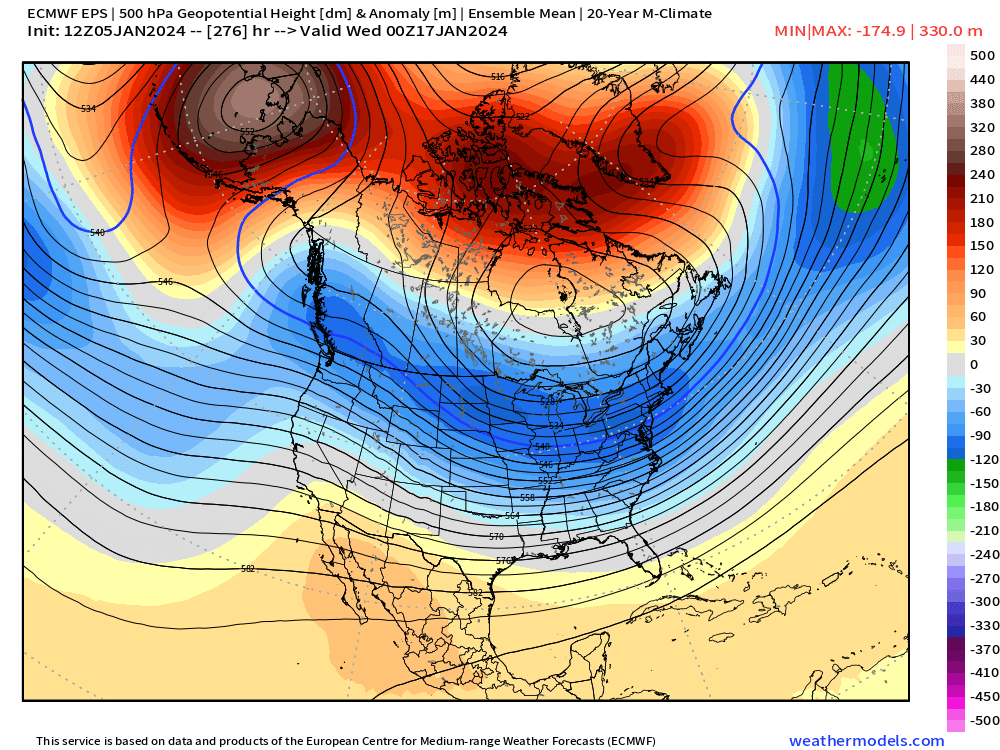
GEFS def trended toward EPS today in the long range…but still not fully there. I think that’s going to be crucial if we want a nice period mid-month into MLK week. Otherwise we might just be waiting for MJO to cruise back into phase 7 and beyond late in the month.
-
Def showed potential for some nice bands regenerating Sunday in eastern areas. I love my old stomping ground in this event…Winter hill in ORH with that elevation and east exposure is gonna clean up with the easterly flow in the BL above the surface. But I think even here should do quite well with easterly flow. Just wish I had a bit more than 350-400 feet of elevation to help. Could be some CF enhancement for a time on Sunday too as that temp gradient tightens before collapsing SE....esp up by Ray
-
Ray jackpot on euro? Hangs back steady light stuff in eastern areas too well into early evening
-
Lol I remember when Pete Bouchard defended your measurement on the air in that storm. Was a cool gesture by him…but he explained that the depth was totally consistent with the 6-hourly measurement when you had fluffy dendrites like that.
-
Also a pretty huge difference between EPS and GEFS. GEFS don’t ever really show a good pattern and reloads the big western Canada PV type pattern at the end of its run. The EPS seems to have a lot more El Niño influence and doesn’t have that. It also retrogrades the NAO block better. But there’s differences in the N PAC too…it has a low out in the GOA underneath the EPO/WPO block (seen below)