
SnowDreamer
-
Posts
436 -
Joined
-
Last visited
Content Type
Profiles
Blogs
Forums
American Weather
Media Demo
Store
Gallery
Posts posted by SnowDreamer
-
-
Regular GFS accumulation plots with numbers


-
 1
1
-
 1
1
-
-
2 minutes ago, high risk said:
really good agreement among most of the CAMs (NAM nest, WRF NMMB, WRF ARW, WRF NSSL ARW) of ice storm warning criteria being met in southern MD.
Convection-allowing?
-
2
-
-
Just now, Deck Pic said:
My forecast for MBY
6-10" with occasional mixing on Thursday afternoon.
That's where you're at on my map lol
-
1
-
-
4 minutes ago, Ji said:
This shouldn't be that difficult to accumulate unless the rates are low since surface is torching at 26
I'm also digging the afternoon highs in the 30s later today. That'll be a nice way to lead into a storm for a change.
-
Just now, Ji said:
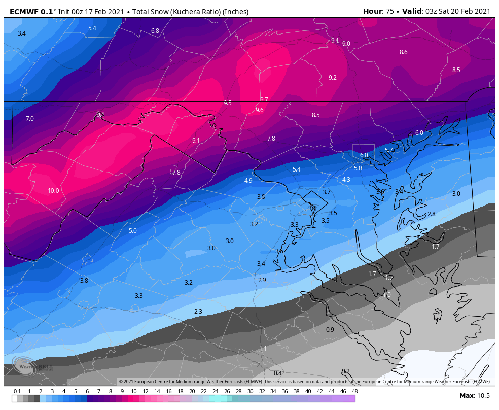
Here is 6z euro

You're comparing apples to oranges there. That's a 10:1, not Kuchera
-
-
Very similar to 18Z for most. Maybe 1-2" less snow for farther N&W crew
-
6 minutes ago, Rhoady said:
Do yourself a favor. Look up the definition of: fall line, the
YW
I told him yesterday too. Sigh
-
1
-
-
Just now, jaydreb said:
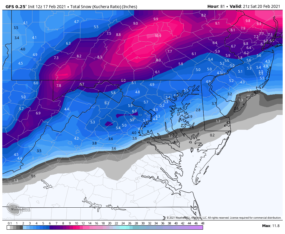
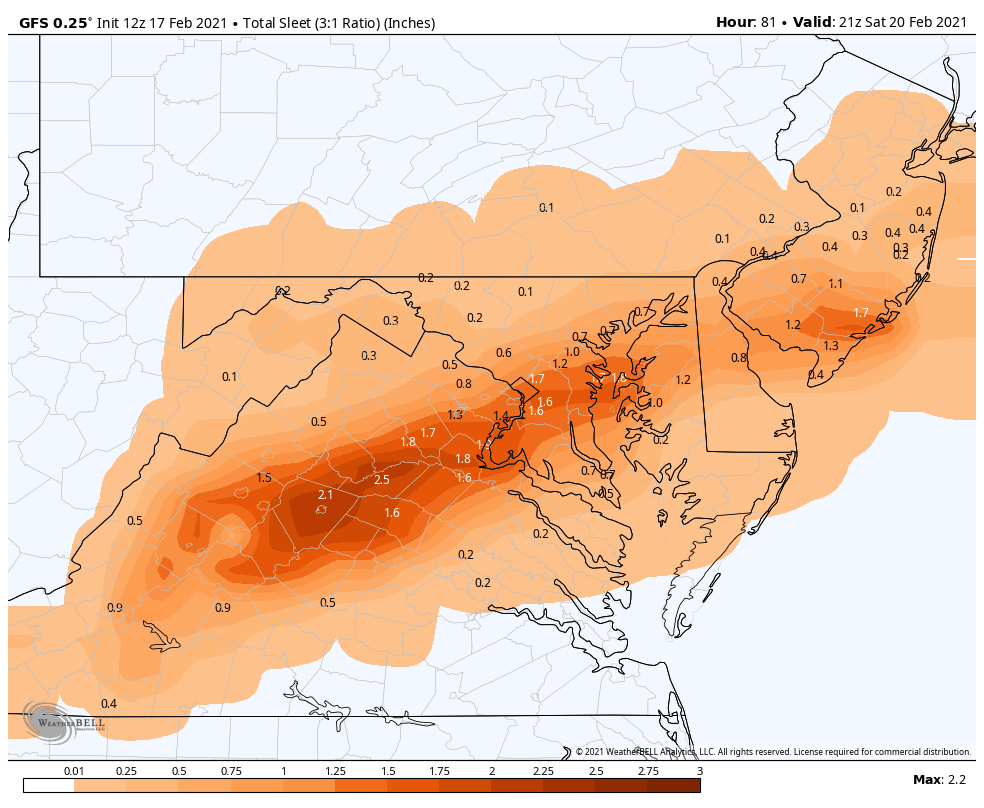
Do you use Kuchera or 10:1 for these? This might be a tough storm to assess because of all the sleet built into the snow totals.
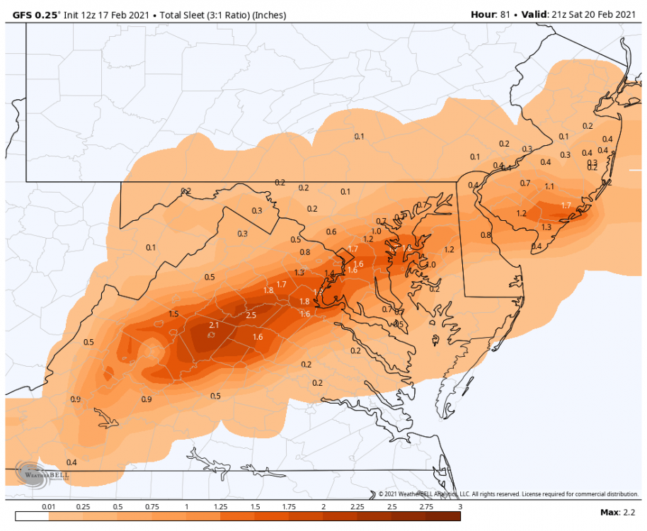
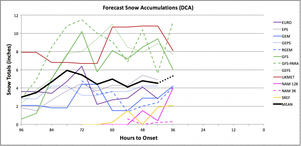
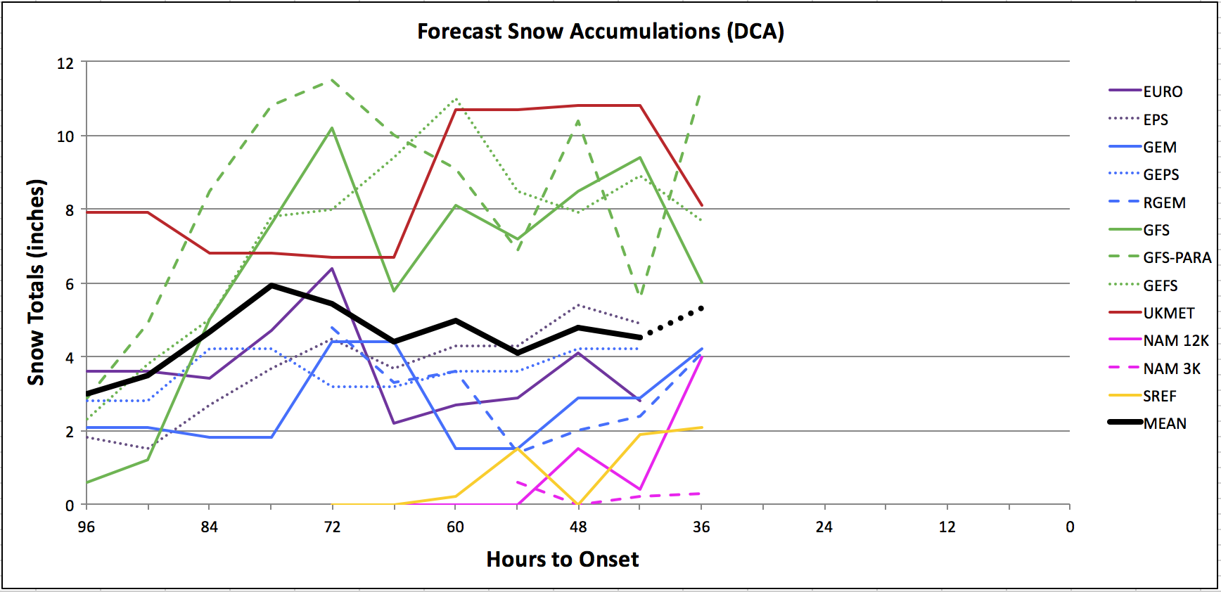
It is tough for some, yeah. These are all Kuchera (WxBell) when available, 10:1 when not. Sleet is not included, and if it were, the NAMs would be considerably higher.
-
With the exception of the PARA, every single model of the 00Z suite so far has moved closer to consensus.
-
7
-
-
All hail king NAM, which has caved for the 4th consecutive run. Thank god
-
1
-
 5
5
-
-
HR 36 Looks colder at 700mb again. I like it.
-
2
-
-
SREFs give 2.1" to DCA, joining the CMC/EURO camp. NAM twins on an island with <1".
-
Just now, DCAlexandria said:
It’s. Not even started yet lol
I know but I just got back to my computer and that was the first thing I saw. The NAM has been @WxWatcher007's right hand man this winter.
-
1
-
-
10 minutes ago, Baltimorewx said:
That’s actually fairly reasonable I think unlike his last couple from what I remember
+1 for this. DT's map still for sure higher than mine, but much more reasonable than usual.
-
3 minutes ago, WinterWxLuvr said:
The 0z NAM looks awful.
The high is 5 miles from where it should be
")
Man don't DO that to me!
-
4
-
-
1 minute ago, wasnow215 said:
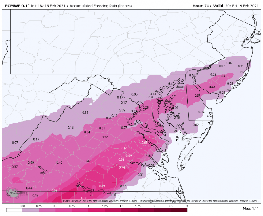
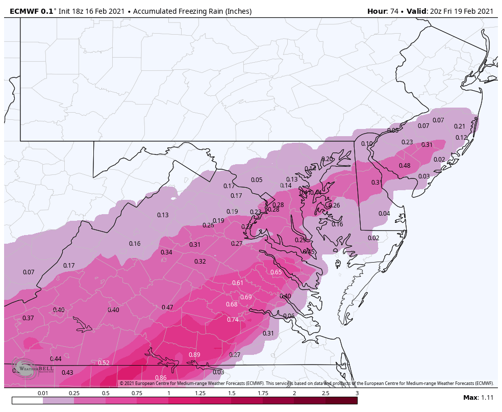
18z Euro fr rain?
I gotchu
-
 1
1
-
1
-
-
26 minutes ago, blueberryfaygo said:
CWG up their totals to 4-8 with 2-4 in the bust range. 5-10 over NW burbs.
8 minutes ago, jaydreb said:I’m a fan of those guys but I will be shocked if that forecast verifies for DCA.
I'm not seeing that anywhere atm, but if that's true it would be an extremely bullish forecast for them.
-
Minor snow showers in D.C. on Friday help add on another inch
Drier and a touch warmer is not a good combo... Small step back from 12Z
-
1
-
-
5 minutes ago, Eskimo Joe said:
Hush. Never doubt the ability of something to pull the football away last minute.
2 minutes ago, chris21 said:Lol! Absolutely true in the dc region. Luckily we are essentially within 36 hours and every hour that ticks by without a sudden shift makes that less likely.
1 minute ago, WxUSAF said:For sure, especially this year. But we're ~36 hours out and still moving the right direction so far.
Past tracking has shown the graphs plummet around 36 hours out (from model init) a few times this season. That would be the 00Z runs tonight. We're looking good, but by no means home free. I'm crossing all available appendages
-
1
-
-
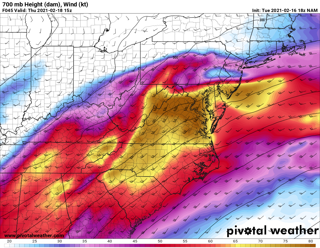
Both NAMs still have those 700mb winds screaming in at 90 knots, temp trend in the right direction anyway

-
36 minutes ago, psuhoffman said:
TREND=FRIEND

-
Interesting panel on run-to-run 850s in the EPS... Significantly colder 850s at the end of the event supports some back-end snow

-
5
-
1
-
-
complete minus EPS for 12Z
SREF and NAMs really pulling down the average, would like to see them join in by 00Z tonight

-
5
-
1
-


February 18/19 Party - STORM MODE
in Mid Atlantic
Posted
Para looking a lot like the old FV3 did a ways back... so weenie