
SnowDreamer
-
Posts
436 -
Joined
-
Last visited
Content Type
Profiles
Blogs
Forums
American Weather
Media Demo
Store
Gallery
Posts posted by SnowDreamer
-
-
Cleaner Euro map - 12Z

-
 1
1
-
 1
1
-
-
2 minutes ago, losetoa6 said:
Ukie looks east of majority of guidance
Classic

-
 1
1
-
-
3 minutes ago, AmericanWxFreak said:
Welp

Looks quite similar to the HRDPS and RGEM, good agreement coming out of the northern neighbor suite tonight.
-
1
-
2
-
-
1 minute ago, jayyy said:
That’s... not how that works. At all. You have that backwards. If it’s a super wet, dense snow, snowfall to QPF ratios are lower lol Cold temps + powder snow = higher ratios. Doubt we see powder.
You're being trolled

-
4
-
-
38 minutes ago, Ravens94 said:
There is several big hits in the GEFS

-
1
-
1
-
-
Just now, WxUSAF said:
This a chip shot NAMing.
I know 12" isn't crazy, but this threat was on life support not long ago and now suddenly the NAM just drops a foot on my house. I feel quite sufficiently NAM'd lol.
-
What's the all-time record for NAM'ing? 18Z today has got to be up there. I mean holy crap! A foot straight up the 95 corridor.
-
12 minutes ago, BTRWx's Thanks Giving said:
What happened to TropicalTidbits' para?
It's been off and on for weeks, but slow to come out even when on. Pivotal has had it pretty consistently but seems to have lost it as of 06z. Not sure where else to look at the moment.
-
10 hours ago, ErinInTheSky said:
It’s got me at 6-8 in Germantown but I’m at 3”. I think both the models and the obs did not realize how much of the precip came down as sleet and freezing rain.
In general I find these maps to be pretty accurate. Do you often find yourself below local obs? If so, I'd suspect possible microclimate.
-
Erm... I seem to have gotten at least another inch overnight. The snow gods are trolling me. Slight bust WAA, very little CCB, but I still make my 4-8? I’m both irritated and ecstatic.
-
-
NOAA Just updated interpolated obs through 00Z... Looks like forecasts won't bust that badly for most. Got me in ~3" which is accurate. I was expecting 4-8".

-
6
-
-
5 minutes ago, JakkelWx said:
LWX is already going with a slight. You know this pattern is gonna produce in some way or anudda
I'm ready to get slighted again.
-
4
-
 1
1
-
-
52 minutes ago, NorthArlington101 said:
Not bad.


That EPS mean is a REALLY nice improvement over 12 hours ago.
-
2
-
-
Flakes suddenly mixing in with freezing drizzle and sleet. First flakes I've seen all day!
-
5 minutes ago, PrinceFrederickWx said:
A close up of my Holly bushes today- Merry Christmas
Thank you. Just thank you. We need more content like this right now.
-
6
-
1
-
-
Just now, Ruin said:
accuweather and intilicast. Yeah i wasnt sure how good or bad those radars are when they do future radar's
Problem is there's no such thing as future radar. That's a model that takes its initial state and runs out some amount of time. Maybe some "future radars" pull their data from actual weather models, but many do NOT. In either case, if you want to use a model, use a real model. Many sites have simulated radar for NAM and other hi-res products.
-
Just now, Ruin said:
hmmm just took a look at current and future radar and the future radar isnt showing anything like the models are showing for tomorrow
 Myabe it hasnt been updated yet?
idk what "future radar" you're using, but there's a 99% chance it's total crap. Most apps/sites that use "future radar" are HORRIBLE.
-
1
-
-
3 minutes ago, Ruin said:
So I have to ask when the weather service calls for heavy snow is it the size of the flakes? or is it the rate in which it falls? or can it be both?
I think of it more like liquid equivalent. Heavy snow=more QPF. Flake size is related to a lot of things like temperature and lift and tends to be good in heavy snow, but it's just a different thing. than heavy/light IMO
-
9 minutes ago, CatoctinRN said:
Frederick(MD) County schools closed tomorrow including all virtual instruction.
Aw come on! That ain’t right. I want my snow day. I got meetings all day tomorrow
-
1
-
-
Medium radar returns down by Lorton are sleet.
-
6 minutes ago, frd said:
North Central NJ on that image from the ICON is a snow magnet when it comes to Miller Bs. Wasn't that a hot spot for Boxing Day too ?
I’m not up on my history since I haven’t been tracking snow for that long, but I do know where to find the answer! It appears you are correct.

-
1
-
-
4 minutes ago, ErinInTheSky said:
I find it hilarious that models are STILL, like 18 hours away, whiffing on how much snow we will get.
Are Miller Bs that bad for us and they mess with models that hard?
Miller Bs are just complicated. Climatologically, they’re not the MOST successful for DC, but that’s neither here nor there. IMO Miller Bs have too many points of variance to be modeled as accurately as something like a clipper or a Miller A. (Although those do bust sometimes)
-
1
-
-
7 minutes ago, frd said:
 6 minutes ago, jayyy said:
Icon can eat my shorts. It’s prob right though.
I’ll eat my shorts if DC gets 8”.
-
1
-
1
-


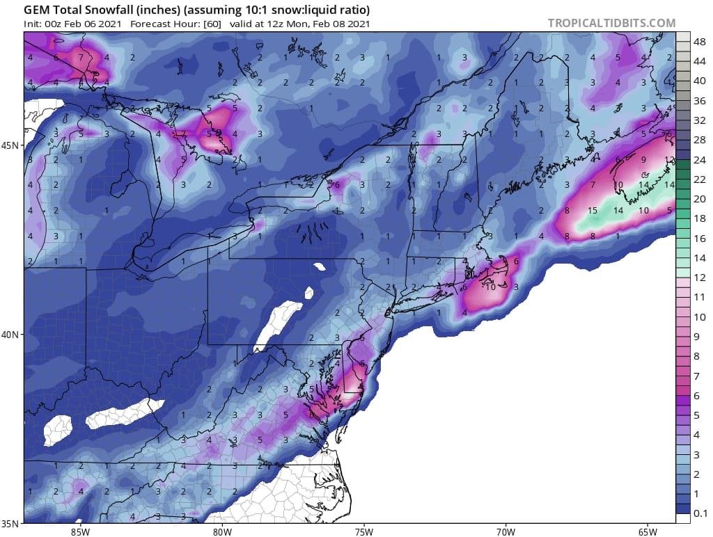


February 7th Storm Threat Discussion/Obs
in Mid Atlantic
Posted
Please be careful about posting total accumulation maps contaminated by other events not in this thread. It doesn't really affect VA/MD in this instance, but better safe than sorry.