

SnowDreamer
-
Posts
436 -
Joined
-
Last visited
Content Type
Profiles
Blogs
Forums
American Weather
Media Demo
Store
Gallery
Posts posted by SnowDreamer
-
-
Just now, SnowGolfBro said:
That comma head will drop a foot of snow in less than 10 hours on those lucky enough to cash in. December 2009 had a similar feature if i remember correctly
It's a common feature in our bigguns once the LP really starts dropping.
-
Look at that comma head tapping moisture out of the gulf. Love to see this! (Control)
eta: Heyo! 100th post


-
 6
6
-
 1
1
-
-
Control looks like a solid setup, already 6-12" in VA and slp is still south of the VA/NC border @144.
ninja'd


-
2
-
 2
2
-
1
-
-
Just now, Interstate said:
Just because one model shows an historical storm doesn’t mean they should elevate it risk any higher. What happens tonight if it disappears. The general population uses these graphics and you cannot have wild swings on them based on one model run.
I totally agree that you can't have wild model swings in a forecast based on 1 run, but the graphic clearly states *potential* impact. The GEM, GFS, PARA all show ~6" for D.C. and the EURO is back-to-back 12"+. I personally wouldn't classify that potential as low, and I don't think I'm alone in that.
-
18Z H5 and SLP vs 12Z - I'll save any prognosticating for the more experienced among us
18Z


12Z


-
2 minutes ago, nj2va said:
One step away from Enhanced
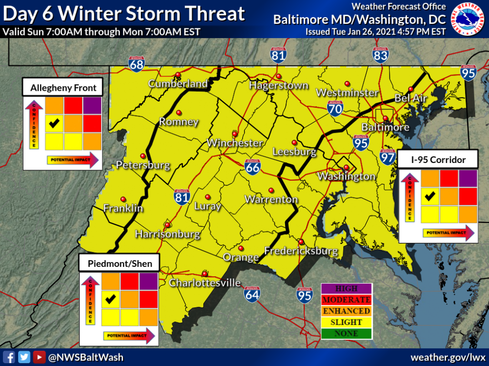
This irritates me. This is not a low-tier potential impact storm. If the point of this matrix is to actually show potential impact, it's at LEAST mid-tier. Euro not withstanding
-
Just now, Bubbler86 said:
There was indeed a fairly strong pushback from people on the forecasts...forecasts which ended up being underdone for most. I was told by one client that it never snows 30" in Virginia.
I believe it! I just meant that the models didn't offer much alternative to the forecast. No real choice on which "camp" to pick. Obviously I'm not going to say it'll snow 24" when the storm is 5 days away, but every day we got closer and the big runs just kept coming. This is opposed to most of our storms where we wait for a camp to cave.
-
1
-
-
I recall the 2016 storm was one of the easiest forecasts I ever made. It was pretty solid from a week out and never really budged, although I think we all expected it to.
-
Just now, BristowWx said:
Think the 18z EPS is 144
correct
-
I count no less than 16 EPS members that give DCA 10"+
With 5 days until it starts snowing here that's crazy.
-
2
-
-
-
I can't wait to see the EPS
tomorrowmorning.
edit: holy crud it's 2am... this morning
-
1
-
-
Just now, jaydreb said:
The Euro is a good model right?
It's best when it shows us getting screwed. Not sure where that leaves us lol
-
Frederick County annihilated
-
I see the forum has solidly transitioned to late-night mode. I'm for it...
The Icon looks pretty good to me. Nice thump and closer to some wrap-around snow than 12Z
-
Temp down to 32 now. Still no snow, but accretion has begun on trees and raised surfaces
-
all sleet making roads and sidewalks crunchy with zero signs of snow in Newington...

-
Anybody have obs from the culpeper death band? Looks like 45 dBZ!
-
6 minutes ago, Eskimo Joe said:
Based of the 0.5 degree CC scan on LWX radar, it appears the melting layer is working closer to the surface. Even a few snow mPING reports in the pan handle of WV now.
I concur, but I thought it was easier to see at higher tilt:
5:18

6:01

-
1
-
-
1 minute ago, Steve25 said:
I've checked a few different radar sources that are showing snow in places it's definitely not snowing. Not completely understanding why that is though
Whatever method the site uses to determine precip types is incomplete. Probably uses surface temp obs and upper air data that's not fine enough to detect the "warm layer"
-
1
-
-
Just now, WinterWxLuvr said:
I would really love to know where that warm layer is
So we can take it out back and give it what for!?!
-
2
-
 1
1
-
-
36/28 down 2 more degrees in the last 30 mins
-
38/29... down a degree since 4:30 but feeling pretty nervous
-
5 minutes ago, GEOS5ftw said:
On the dual-pol radar correlation coefficient, there is indication of melting at around 3000 ft (eyeballing the 3.1 degree scan). Something to watch if this disappears as the heavier precip moves in.
I've never heard of this technique... Are you using trig and distance from the dish to estimate here?


January Storm Term Threat Discussions (Day 3 - Day 7)
in Mid Atlantic
Posted
The 12Z OP has started phasing with that bit of energy by then and 18Z Control hasn't, but I think the control is just a little slower judging from the ULL and the SLP position. I think it might still get to about the same place. Something to watch for in the 00Z run.