
SnowDreamer
-
Posts
436 -
Joined
-
Last visited
Content Type
Profiles
Blogs
Forums
American Weather
Media Demo
Store
Gallery
Posts posted by SnowDreamer
-
-
1 minute ago, Wetbulbs88 said:
I know this is really stupid but...how the heck do you change locations? Trying to get a vantage from farther SW.
-
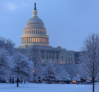
DCA just clinched the biggest snow in 2 years!.. With 1.4"

-
 2
2
-
-
1 minute ago, JMcCaughey42 said:
Wow would love to see the snow map for that lol
Just for you. Can't capture the whole thing on Kuchera without contamination, so the old 10:1 is gunna have to do. Kuchera is more

-
 1
1
-
 1
1
-
 2
2
-
-
HELLO! Perfectly respectable MECS Miller A in exactly 7 days...
Looks like 12"+ forum-wide as long as you're NW of the R/S line.
-
1
-
-
Pixie dust continues for me. Just hit the 2" mark... up from 1.75" at 11

-
1.75" and lovely outside. Took the typical loop for this morning's jebwalk, but doggo decided it was too cold half way through and we had to return to shelter - Was unable to convince him that continuing would be just as fast.

-
3
-
-
Just now, NovaTarHeel said:
To any cliff jumpers up there, it's not over yet. I'm rooting for y'all to get deformed (not really, I hate you all and want to move back to NoVa but houses are too damn expensive and I can make the same money in Richmond for a lot cheaper, but I'm contemplating taking a pay cut to have better snow chances.).
You, sir, get my vote for realest post of the evening, narrowly edging out Bob with the "blown load" comment a few minutes ago.
-
1
-
-
11 minutes ago, NorthArlington101 said:
FWIW. Probably not a lot. Looks a lot like the NAM/HRRR, though.

Epic DC screw job. Probably verifies

-
1 hour ago, Weather Will said:
Latest SREF has increased since last run which can’t be bad...


It had been going down for the last several in DC, so this is nice to see
-
5 minutes ago, Jmister said:
As the storm begins to approach the area, here's a shameless plug for my tool to help ease your radar hallucinations. Specifically for the HRRR simulated radar.
The green regions in KY, NC, WV show that it's under-doing the precipitation extent there right now.
Good luck to you all down here!
I notice that showing a lot of extra precip around the fringes. Do you find that your product shows HRRR underestimating the outer-edges of precip. often, or is this unusual?
-
Just now, BTRWx's Thanks Giving said:
It's trending the low north too.
For sure
-
With respect to deform band - EPS has been pretty consistently trending stronger

-
6
-
-
1 minute ago, H2O said:
Just one slight shift south. Please. Want people to say that things look great from H2Os house north
Yes plz. We can have our little kumbaya circle together for the 00Z suite
-
3
-
-
QPF vs 12Z big bump for immediate DC and NOVA, tick N


-
4
-
-
Gunna be higher QPF for most than 12Z, esp DC. will post comparison when it's done
-
WAA thump-7p Sun

-
5
-
2
-
1
-
-
18 minutes ago, diatae said:
Jumble Sale cab. Cheers!
Cheers! I'm going with some crown royal and coke tonight.
-
1
-
-
7 minutes ago, WinterWxLuvr said:
No worries. I just wanted to the geps LOL.
Sorry, I didn’t quote the map because I was trying to reduce clutter for “storm mode”
-
Just now, wxtrix said:
then what are you talking about?
It's not uncommon for their forecasts to give >50% chance to combined boom and bust scenarios. I've seen it many times on their site. Again, no hate for CWG. I love love them and I think they do a fantastic job. The percentages they put out for those booms and busts read wonky to me, that's all.
-
Just now, wxtrix said:
no one has an actual forecast right now. good grief.
I'm not referring to their current forecast. I have no idea what their current forecast is.
-
Just now, leesburg 04 said:
I mean this calls for a CWG type forecast 3-6" with a boom scenario of 3-12" and a bust scenario of 0-3"
I love CWG, and they were a big inspiration to me. That being said, when they give a forecast saying 30% bust and 30% boom chances... my takeaway is that they think their main forecast is more likely wrong than right.
-
2
-
-
LOL the Euro is now the worst model for MBY... That happened so fast.
-
That GEPS mean looks like every textbook I-95 MECS
eta: map on previous page - trying to reduce clutter
-
5
-
1
-
-
2 minutes ago, BigCountry said:
I'm definitely not any level close to the rest of you, but that seems fairly low at this point. My initial thoughts right now are more in the 6-10" range.
You'll find that many reputable meteorologists (read: not DT) forecast notably below the snow total maps we post here. And FWIW, they have a good reason to do so.
CWG is also more conservative than many
-
1
-


Feb Long Range Discussion (Day 3 and beyond) - MERGED
in Mid Atlantic
Posted
There's a little somethin' somethin', but you know D7 means. It's there