Albedoman
-
Posts
1,321 -
Joined
-
Last visited
Content Type
Profiles
Blogs
Forums
American Weather
Media Demo
Store
Gallery
Everything posted by Albedoman
-

E PA/NJ/DE Spring 2023 OBS Thread
Albedoman replied to Hurricane Agnes's topic in Philadelphia Region
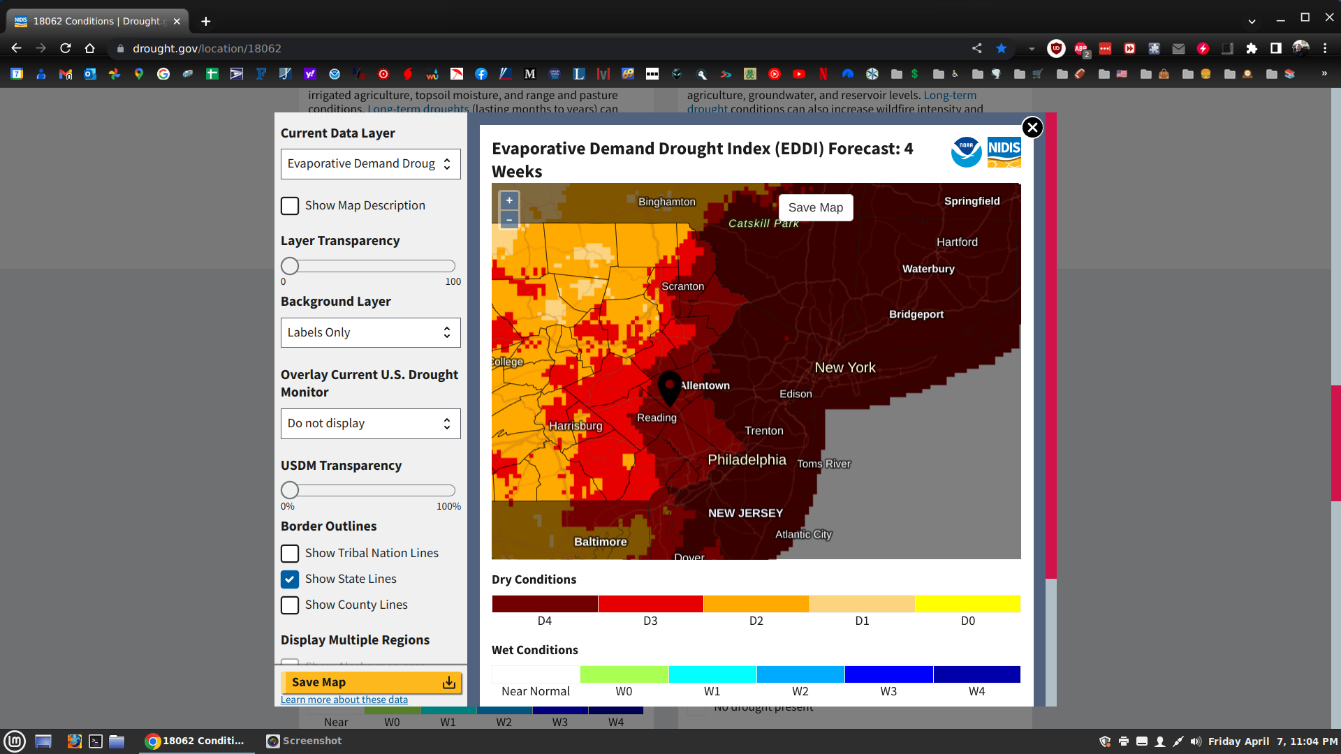
can you say sucking the living hell out of the soil moisture and lowering the groundwater tables in the next 4 weeks.
-
E PA/NJ/DE Spring 2023 OBS Thread
Albedoman replied to Hurricane Agnes's topic in Philadelphia Region
the infamous winter donut hole LMAO -
E PA/NJ/DE Spring 2023 OBS Thread
Albedoman replied to Hurricane Agnes's topic in Philadelphia Region
too late, we are all getting stung. I see no appreciable rainfall in the next week or so. I believe drought watches will be hoisted by the end of next week as stream flow levels are in drought conditions already exist in our area. The wells levels will drop significantly as people begin to water their plants and gardens as the releafing process is ongoing this next week. Less than .25 inch of rain tonight is not cutting it- just dusting down the parched soils. I expect that we are in the beginning of a nasty drought coming at the end of the this La Nina year which is very typical and I have been stating this all winter in this thread. -
E PA/NJ/DE Spring 2023 OBS Thread
Albedoman replied to Hurricane Agnes's topic in Philadelphia Region
Nice cloud to ground lightning, gusty winds but what the hell, hardly any rain. All day long, only received less than . 50 in the bucket. I have seen a much worse storm in the Lehigh Valley thats for sure. C'mon I need at least 1-2 inches of rain on Wednesday. The stiff NW winds today will parch everything pretty quickly. We really need a rain producer before the trees releaf. -
E PA/NJ/DE Spring 2023 OBS Thread
Albedoman replied to Hurricane Agnes's topic in Philadelphia Region
way long time ago under the old forum. Do not remember the exact time before 2017. I believe somebody else had that name too. Thats why I changed it. -
E PA/NJ/DE Spring 2023 OBS Thread
Albedoman replied to Hurricane Agnes's topic in Philadelphia Region
You guys better start thinking about drought instead of cold and warm. Not having more than .50 inch of rain in weeks here at my house is worrisome. Usually the ground is so wet, I cannot even drive the mower on it. Once the tree releaf begins and the temps hit near 70, its game on as the moisture will really get sucked out of the ground. Fortunately the soil temps are below normal now but that can quickly change with a few sunny 70 degree days. I am hoping Saturday we can get an inch of rain with some t- storms but I am not holding my breath as this stagnant light shower weather pattern refuses to budge. I am so tired of either the constant cloudy cold days or sunny blowing your ass around days. It has been this way for the entire month. 50 degree sunny days with 30 mph + northerly winds is not productive. -
Time to start tracking t- storm events
Albedoman replied to Albedoman's topic in Philadelphia Region

-
Time to start tracking t- storm events
Albedoman replied to Albedoman's topic in Philadelphia Region
wow- t storms in the forecast the next few days. Well beats the hell out of this past winter. Bring it on and we really need the convective gully washers -
The Ides of March end of Winter 2023
Albedoman replied to paweather's topic in Upstate New York/Pennsylvania
ah don't worry, our drought is just starting. No significant rain events in the immediate future. 1-2 in of rain since January is not going to cut it it with no snow base. The fire watches/red flags are only the start of the drought problems in these past few weeks. If we get no significant rain events by leaf out, we will be in a drought folks. Well yields and stream flows will be down big time. This happens after every La Nina winter pattern like clockwork. What breaks the drought-- early season tropical storms -
The Ides of March end of Winter 2023
Albedoman replied to paweather's topic in Upstate New York/Pennsylvania
That model is on a snow high for sure. NO way. -
E PA/NJ/DE Spring 2023 OBS Thread
Albedoman replied to Hurricane Agnes's topic in Philadelphia Region
NO way in hell does this work out for us. There is not enough cold air in the profile. Just toss this crap back into the hopper. -
E PA/NJ/DE Spring 2023 OBS Thread
Albedoman replied to Hurricane Agnes's topic in Philadelphia Region
I finally found out what pattern we are now in -
E PA/NJ/DE Spring 2023 OBS Thread
Albedoman replied to Hurricane Agnes's topic in Philadelphia Region
March snow squalls only the light version nothing more. Agree will be gone quickly. Batter up for next week though. -
E PA/NJ/DE Spring 2023 OBS Thread
Albedoman replied to Hurricane Agnes's topic in Philadelphia Region
Game on. The models keep spitting out a deepening LP late next week. The precursor for a MAJOR pattern change IN THE MAKING signified by todays BS system becoming the eventual blocking mechanism for next weeks storm for us. Now you can say buckle up. -
E PA/NJ/DE Spring 2023 OBS Thread
Albedoman replied to Hurricane Agnes's topic in Philadelphia Region
Thanks for checking Mike. Typo? -
E PA/NJ/DE Spring 2023 OBS Thread
Albedoman replied to Hurricane Agnes's topic in Philadelphia Region
I have a clip for the MT Holly guys writing this discussion for the LV this morning--- Whats even more unbelievable is that 6-10 warrants a winter storm watch and they did not even issue one. Yes I agree it is warranted as a minimum If the cold air buildup upon in a deepening coastal LP, the rain will likely turn to heavy wet snow in an extreme dendritic growth situation and MT Holly will be forced to issue a winter storm warning after we had 3+ in of snow on the road in the LV. With all the truck traffic in the LV, thats a disaster in the making. Why even mention if you are not sure. -
E PA/NJ/DE Spring 2023 OBS Thread
Albedoman replied to Hurricane Agnes's topic in Philadelphia Region
My forecast - From northwest NJ to Long Island from Northern Surekill county to the Poconos 6 -12 inches of snow. From LV west into Harrisburg 1-2 in of wet slop on the grass. Anyone south of LV might as well go pound sand. Winter is dead folks and this next storm will slap the hell out of the Philly metro area and even the LV for snow accumaltions. NIMBY syndrome for sure when it comes to snowfall events for se and south central PA -
Time to start tracking t- storm events
Albedoman replied to Albedoman's topic in Philadelphia Region
Looks Promising as temps jump into the 60's. God I would love to see some training t storms. That would make up for this crappy March worth it. The Hail I could live without but a continuous lighting storm would be like getting a nor'easter KU storm right now without the shoveling. Bring it on bay and for you Ralph Buckle up. -
This thread is for tracking t- storm events only. Its time we all stop wishful thinking of a KU event happening this spring and start tracking our next squall line event.
-
E PA/NJ/DE Spring 2023 OBS Thread
Albedoman replied to Hurricane Agnes's topic in Philadelphia Region
we have been good to toss in winter since the first week in January. Time to think t- storms. We should be tracking them as much as we have been chasing these BS snowstorms on the models. This is the first year in my memory (35 years) that I have not had to even bring out the shovel as the snow is gone in less than 24 hours. The snow that has been recorded at LVI has been all from either white rain snow events that have melted away in less than 12 hours or a dusting from a weird snow squall. The dusting we had in the arctic outbreak in December blew away and evaporated. I have more dust on my snow shovel and snow thrower. The real issue to ponder- what the hell happened to all of the alberta clippers in January and was this disappearance a true pretext to our crappy winter? This year will be known as the year without snow and the year of the lake cutters. I heard more thunder than I saw snow this winter. Disgusting. Also this winter season is known as the season without sunshine. So many cloudy days with crappy below normal temps thus far in March. What stands out the most however in this pattern is the fact that we had so so so many cloudy nights with record warm overnight lows from fall and lasting into the winter season. Whatever happened to the fall crisp and clear nights or the cold clear bitter nights in winter? I am ready to go back to normalcy that is for sure. I hope April brings on a new weather pattern with warm spells and t- storm frontal passages -
E PA/NJ/DE Spring 2023 OBS Thread
Albedoman replied to Hurricane Agnes's topic in Philadelphia Region
.5 inch of snow does not cut it with me for precip totals. At this points 1-3 in snows are worthless. I would rather see 1" rainfall totals right now to recharge the parched groundwater tables. This week alone we had two wildfire hazardous messages. If this crappy weather pattern does not break soon, we will be heading into a drought in late April and streamflows will be down big time as the water gets sucked out of the ground during the releafing process. -
E PA/NJ/DE Spring 2023 OBS Thread
Albedoman replied to Hurricane Agnes's topic in Philadelphia Region
Four degree daily anomaly and this indicates spring? Had to really dig this one up? Notice the blue in the Chesapeake Bay area. All this model tells me is that there is a decent chance of a Nor'easter forming as the cloudy and really cold rainy days continue until the second week of April Thanks anyway. -
E PA/NJ/DE Spring 2023 OBS Thread
Albedoman replied to Hurricane Agnes's topic in Philadelphia Region
Sorry, but what guidance is showing Spring? I have yet to see a 70+ degree in the next 15 days. In fact the temps for the rest of March may not even hit the 60's. Spring to many of us is 70+ degree days with t-showers. Hell the soil temps are still so cold , the grass will not turn dark green yet. The leaves on my pussy willow tree have not even budded yet. 5 out 7 days a week of Cloudy 40 degree days just do not indicate Spring to me yet. We just do not have the white crap on the ground this year thats all. Give me Feb again as that was a spring month to me. -
E PA/NJ/DE Spring 2023 OBS Thread
Albedoman replied to Hurricane Agnes's topic in Philadelphia Region
what a joke 1" in Reading and nearly 8 in at ABE Give me a break. That run is on drugs. Overdose on heroin model run and Narcan cannot even save it. -
this better explains it as I posted in the Philly forum the models trying to hot a bouncing ball and we get whiffed everytime