

Albedoman
-
Posts
1,321 -
Joined
-
Last visited
Content Type
Profiles
Blogs
Forums
American Weather
Media Demo
Store
Gallery
Everything posted by Albedoman
-

January 25-26 Winter Storm Potential
Albedoman replied to Ralph Wiggum's topic in Philadelphia Region
thundersleet -
January 25-26 Winter Storm Potential
Albedoman replied to Ralph Wiggum's topic in Philadelphia Region
Note this. I am NOT chuckling: As long as the column saturates quickly enough, any snow thatfalls late Saturday night and into early Sunday morning could bevery high ratio, fluffy, rapidly accumulating snow thatconsists of many pristine dendrites (SLRs 15-20:1, could beeven higher if the column saturates faster but there is dry airat low levels to overcome at onset). So after a few hours ofvirga, accumulations have the potential to begin with avengeance in the predawn hours Sunday, especially from I-80south.” -
January 25-26 Winter Storm Potential
Albedoman replied to Ralph Wiggum's topic in Philadelphia Region
I am not chuckling any more about the snow ratios and the location of the benchmark LP in the delmarva, The experts agree with me. Area Forecast Discussion National Weather Service Mount Holly NJ 316 PM EST Thu Jan 22 2026 .WHAT HAS CHANGED... Cold Weather Advisories have been issued for the entire area for Friday night due to dangerously cold wind chills below zero. While models are trending north with the weekend storm system, resulting in more of a wintry mix, significant snow impacts are still expected. A Winter Storm Watch remains in effect for Saturday night through late Monday morning. && . KEY MESSAGES... 1. Several cold fronts will be tracking through the area through Friday night. This will be the transition from the warmth to an arctic airmass bringing dangerously cold wind chills to all of the region by Friday night and into the start of the weekend. 2. Low pressure will impact the area Saturday night through late Monday morning with significant snow accumulations, however, a wintry mix of freezing rain, sleet, and even plain rain may result in lower snow accumulations than would otherwise be expected. 3. Arctic air will remain over the area next week with temperatures not rising above freezing until possibly next weekend. && .DISCUSSION... KEY MESSAGE 1...Several cold fronts will be tracking through the area through Friday night. This will be the transition from the warmth to an arctic airmass bringing dangerously cold wind chills to all of the region by Friday night and into the start of the weekend. Seasonably warm temperatures in the mid 40s to mid 50s are occuring across the area this afternoon. The warmth will be short-lived however, as we`ll be transitioning to an arctic airmass over the next 24-36 hours. The initial cold front is currently located over east-central Pennsylvania and will track east across the Mid- Atlantic and off the coast by this evening. Wind gusts up to 30-40 mph have occurred across much of the area, but will diminish into tonight as the front departs. Temperatures tonight will fall back to more seasonable levels with lows mainly in the upper teens to upper 20s under partly to mostly cloudy skies. Temperatures on Friday will remain seasonable for one more day; topping out in the low to mid 30s north and west to low to mid 40s south and east. This will be the last of `normal` temperatures for quite a while as a potent secondary arctic front sweeps across the area by mid to late afternoon. Strong cold air advection pours into the region for Friday night where 850 mb temps are expected to range from -15C to -25C. This equates to surface temps falling into the single digits (or below zero on the Pocono Plateau). Not only will the temperatures be falling rapidly, but winds will pick up in wake of the secondary front; driven by a tightening pressure gradient between a very strong 1044 mb arctic high and departing low. This combination of single digit temperatures and wind gusts upwards of 25-35 mph will result in wind chills below zero areawide. For this reason, have issued a Cold Weather Advisory for the entire forecast area for Friday night through Saturday morning. Where winds may be slightly higher and temps will be colder, wind chills may get as low as -20F on the Pocono Plateau. Possible upgrades to an Extreme Cold Warning cannot be ruled out for Carbon and Monroe Counties in PA. While the peak of the cold air aloft occurs Friday night, the arctic airmass remains overhead through the day on Saturday with strong surface high pressure building over the Great Lakes. High temps will only be in the teens to low 20s but fortunately winds will be diminishing. Dry conditions are expected through Saturday. This will be the last day to prepare for any storm preparations, so take any necessary precautions as needed to stay warm if outdoors. KEY MESSAGE 2...Low pressure will impact the area Saturday night through late Monday morning with significant snow accumulations, however, a wintry mix of freezing rain, sleet, and even plain rain may result in lower snow accumulations than would otherwise be expected. Arctic high pressure will be north of New York State Saturday night and will gradually lift to the northeast throughout the day Sunday, finally departing Sunday night. Meanwhile, a deep upper trough will continue to exit out of the Rocky Mountains and surface low pressure continues to organize and develop over the Gulf Coast states Saturday night through Sunday morning. Surface low then takes a run towards the Mid-Atlantic Sunday afternoon and evening before moving offshore and out to sea Sunday night through Monday. Overrunning precipitation develops on a developing warm front out ahead of the surface low Saturday night. With temperatures mainly in the teens, any precipitation that develops will be snow and snow accumulations will occur quickly. With snow ratios from 15-20:1, can expect a quick 1 to 3 inches over northern zones, 3 to 6 inches from around Philadelphia, through southern New Jersey, and into northern Delmarva, and 5 to 7 inches across southern Delmarva. What will need to be watched is if snow ratios lower late at night across southern Delmarva as warmer air lifts to the north. From there, snow continues to ramp up throughout the day Sunday. 12Z models have continued to trend to the north, and as a result, more in the way of warmer air will spread into the region aloft. The 12Z/22 ECMWF looks to be centered over the Delmarva Peninsula by Sunday evening, while the 12Z/22 GFS has the center of the low some 50-100 miles southeast of the ECMWF. The 12Z NAM now goes out until 00Z Monday and splits the difference between the ECMWF and GFS. The 12Z/22 CMC is even a bit more to the northeast than the ECMWF. Ultimately, this results in a warmer solution, and can expect a wintry mix of sleet and freezing rain well into southeast Pennsylvania, mainly along the I-95 corridor, and northern New Jersey, while rain and snow will develop along the New Jersey coast and southern Delaware. For the southern Poconos and far northwest New Jersey, precipitation remains all snow. Cannot rule out a period of plain rain for portions of the southeast New Jersey coast and southern Delaware coast. This wintry mix continues through Sunday evening before changing back to all snow late Sunday night. Snow then continues into Monday morning before ending. Overall, snow accumulations look to be on the order of 12 to 15 inches for the majority of the area, with slightly less in southern Delmarva. While liquid QPF will be lower in the northern zones, the higher snow ratios will result in higher snow amounts in those areas. The main issue continues to be how much mixing will occur and how that will affect snow accumulations. While the overall average looks to be 12 to 15 inches, it is also quite possible for accumulations to be less, generally on the order of 8 to 12 inches from around Philadelphia south, with even less in southern Delmarva and along the extreme southeast New Jersey coast. The Winter Storm Watch remains in effect through late Monday morning/early Monday afternoon. KEY MESSAGE 3...Arctic air will remain over the area next week with temperatures not rising above freezing until possibly next weekend. High pressure builds in from the north on Monday, and temperatures will be fairly cold with highs generally in the 20s to maybe low 30s in the far southern portions of the forecast area. A strong cold front then passes through Monday night and bitterly cold Arctic air spreads into the region with lows in the single digits Monday night and highs in the teens on Tuesday. Cold Weather Advisories and even Cold Air Warnings may be needed due to low wind chills as strong northwest winds develop behind the front. Highs will then be only slightly warmer Wednesday and Thursday. Due to this prolonged period of sub-freezing temperatures, do not expect any help from Mother Nature with melting the new snowpack. In fact, temperatures may not get above freezing until next weekend. -
January 25-26 Winter Storm Potential
Albedoman replied to Ralph Wiggum's topic in Philadelphia Region
I agree 25:1 ratios are impossible for here but I have seen almost 20:1 here in storms before, epecially when the LP wraps up at the benchmark and upsloping along the Blue and S Moutains exist. Not quite as impressive as out west with the higher elevations like in the Sierras and Bitterroots etc but it is nothing to sneeze here if the quebec high is strong enough. That is why I say 1035mb is the minimum for any good storm to come about here with higher snow ratios. -
January 25-26 Winter Storm Potential
Albedoman replied to Ralph Wiggum's topic in Philadelphia Region
In northern Lehigh county, drifting is a huge deal. Urbanized areas, basically no issue. Many of the posters don ot even know where Lowhill Township is in Lehigh County. South mountain topgraphically is the cutoff for sleet in this storm -
January 25-26 Winter Storm Potential
Albedoman replied to Ralph Wiggum's topic in Philadelphia Region
ITs on the mark. LV has been an overpeformer all winter thus far. Srating with the 16+ in of snow this year to -10 yesterday. Mt Holly and the NBM models are spot on. My criteria is also being met for a MECS scenario. The LP moving closer to the BM should close the deal in the the mesos runs OZ tonight. CCB and where it sets up with bandingwill be the tell all for final snow accumalations. Still, biggest concerns, drifting in the rural areas and extreme cold Mon- Wed -
January 25-26 Winter Storm Potential
Albedoman replied to Ralph Wiggum's topic in Philadelphia Region
go ahead and laugh but i been in both situations. How old are you? -
January 25-26 Winter Storm Potential
Albedoman replied to Ralph Wiggum's topic in Philadelphia Region
1994 all over again folks if that happens -
January 25-26 Winter Storm Potential
Albedoman replied to Ralph Wiggum's topic in Philadelphia Region
The 1035 HP is still in play saying it for days -
January 25-26 Winter Storm Potential
Albedoman replied to Ralph Wiggum's topic in Philadelphia Region
The HP in Quebec over 1035 is great sign that it will win out if it is maintained. Sleet may mix at times during the heavier snow bands, especially in the potential instability. I cannot wait to see the soundings for the potential of thundersnow with 3-4+ in hr snowfall rates in the mesos. That makes this a classic great snow storm and is the icing on the cake IMHO. -
January 25-26 Winter Storm Potential
Albedoman replied to Ralph Wiggum's topic in Philadelphia Region
this 12z map is for every snow weenie DREAM out in the forum, especially for LV the bullseye. To get almost 1.5 times your annual snowfall by Ground Hogs day is actually playing into the movie of Ground Hogs Day, rerun after rerun The nice thing, it has POTENTIAL ----- LMAO -
January 25-26 Winter Storm Potential
Albedoman replied to Ralph Wiggum's topic in Philadelphia Region
https://www.lehighvalleylive.com/weather/2024/02/lehigh-valley-weather-heavy-band-of-snow-dumps-foot-or-more-from-macungie-to-hellertown.html#:~:text=Lehigh Valley weather%3A Heavy band,more from Macungie to Hellertown&text=Snow falls in the Lehigh,Valley on Feb. 17%2C 2024. -
January 25-26 Winter Storm Potential
Albedoman replied to Ralph Wiggum's topic in Philadelphia Region
at 17:1 ratios as a minimum with greater than 25:1 as a max with this storm, 2 ft is achievable --AI euro has same issues. Blowing and drifting will be a huge issue too -
January 25-26 Winter Storm Potential
Albedoman replied to Ralph Wiggum's topic in Philadelphia Region
-5 at abe. -9 at my house so deep in the LV. Coldest since 94. I already posted that storm in 94 as refenced it got to -15 at ABE all time cold record. . OMG just wait until this storm passes. Temps will be below -10 easily and may not even get out of the single digits for highs. You guys got your feicking cold thats for sure- now watch the utility bills climb. -
hey Ralph, its meetimg my criteria of a 1035 High at 1037 with the LP off the carolina coast heading for the benchmark. Winner winner chicken dinner.
-
January 25-26 Winter Storm Potential
Albedoman replied to Ralph Wiggum's topic in Philadelphia Region
-3 at the house. now. This storm is going to cripple the TN valley. After the ice and snow leave this area, the temps will be -10 dgrees even in Nashville. Pipes bursting, no power . Declared federal disaster areas. These idiot protestors in MN better worry about their friends in the south because many are going to be without power and heat for weeks. This IMHO could rival TS Helene in damage. This storm is going to send those global warming radicals back to the basement too. This is getting serious -
January 25-26 Winter Storm Potential
Albedoman replied to Ralph Wiggum's topic in Philadelphia Region
MY reasoning why: as more w pac data finally gets ingested into the GFS since it is hamstrung on obtaining reliable data for baja Ca/4 corner lows and when the LP will be ejected out to arklatex area -
January 25-26 Winter Storm Potential
Albedoman replied to Ralph Wiggum's topic in Philadelphia Region
the media pressure will be too much or model agreement will have to be stupendous and overwheelming once the GFS comes on board. I am concerned with the severe cold afterwards not the amounts of precip. You have an entire generation of drivers that have never driven on powdery snow that is compacted into 4 inches of solid ice with no salt to melt as temps in the single digits. The region better keep the truck drivers off the interstates or we all see 100 car pileups. As an old timer, this situation with the cold though not as severe as 1994 reminds of one thing friends Just look at where everything is lined up in this weather channel video see below The 1994 ice storm (specifically the January 7–8 event) effectively paralyzed the Lehigh Valley, turning routine travel and daily activities into significant hazards. Transportation Impacts Road Closures and Accidents: Freezing rain transformed roads into "ice skating rinks," leading to hundreds of accidents across southeastern Pennsylvania. A notable 16-vehicle pileup occurred on westbound Interstate 78 in Lower Saucon Township due to the sudden icing. Stranded Vehicles: Many motorists were forced to abandon cars on snow- and ice-covered highways. Public transit, including some Greyhound bus services, was suspended, leaving travelers stranded at terminals. Public Transit Standstill: Regional transit systems like SEPTA and Amtrak faced major delays or complete shutdowns, with some services taking nearly a week to return to normal. Airport Disruptions: Lehigh Valley International Airport (then ABE) and other regional hubs like Philadelphia International faced multi-day closures due to icy runways. Impacts on Daily Life Widespread Power Outages: Heavy ice accumulation—up to 1 inch—downed thousands of trees and utility lines. Approximately 400,000 to 590,000 customers in the broader region lost power, with many remaining in the dark for over a week. School and Business Closures: Schools across the Lehigh Valley were closed for multiple days. In some instances, schools that attempted to open had to send students home early as conditions worsened, leading to buses becoming stranded on rural roads. Supply Shortages: Panic buying led to severe shortages of staple items; locals reported that "not a loaf of bread" could be found in some city stores. Hardware stores quickly sold out of generators, kerosene, and salt. Hazardous Conditions: Falling tree limbs and "snapping" sounds like gunshots were common as the weight of the ice became too great for trees to bear. Walking outdoors became extremely dangerous due to the thick coating of ice on sidewalks. Infrastructure Failures: The extreme cold and heavy precipitation during this period contributed to the eventual collapse of the Corporate Plaza building in Allentown due to a massive sinkhole -
January 25-26 Winter Storm Potential
Albedoman replied to Ralph Wiggum's topic in Philadelphia Region
I am not too worried yet. Its dry like this on average years during this time frame. Concerns: 1. Being a neutral year, we are in for a real cold and snowy winter which will definitely help the groundwater tables. See lots of northeaster's and the potential freezing rain/sleet events early in December. Expecting some nice rains by mid October as the warm pattern breaks down. A good tropical storm up the east coast can really help get us out this stubborn pattern. Said this Nov 23 The models have shown only one positive thing in the last two weeks for a major pattern change and a possible major snow event for us but when it will ever occur will just be plain luck. If you old timers recognize the current major pattern shift on the last weeks runs which we have not seen in nearly 6-10 years is identified as the four corner lows which are developing and pushing into the Gulf of America. Then these lows are quickly re-energized with a ton of moisture and are setting up for a good Miller A type of storm event- rain or snow along the east coast. The lows south of New Orleans into Tampa are impressive on the model runs. This is the best look in model runs in a long time as it appears the GOA is opening back up for business, however these low pressure systems are also quickly becoming southern sliders too. The cold dry air that does come through with a cold front is NOT retreating back up into Canada so quickly before the moisture reaches us. Would not be surprised if the Carolina's up to Washington DC sees more accumulating snow then us this year. -
January 25-26 Winter Storm Potential
Albedoman replied to Ralph Wiggum's topic in Philadelphia Region
NAM at 48-56 hours HRRR at 36 to tighten it up. Thursday evening will tell us all what is going to happen, The watches should be out by then -
E PA/NJ/DE Winter 2025-26 Obs/Discussion
Albedoman replied to LVblizzard's topic in Philadelphia Region
This looks promising for the LV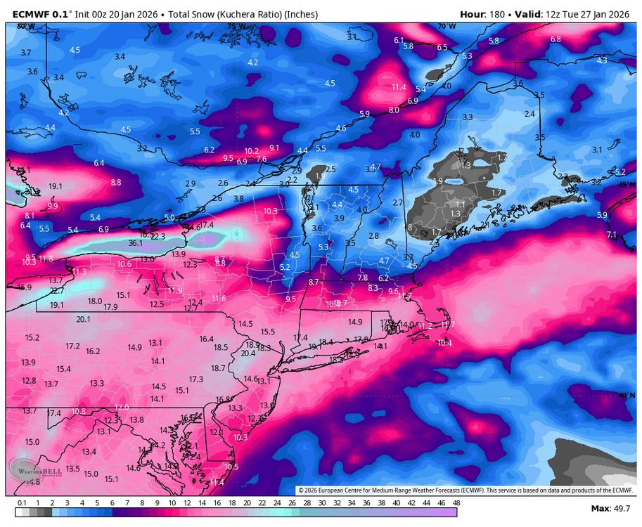
-
E PA/NJ/DE Winter 2025-26 Obs/Discussion
Albedoman replied to LVblizzard's topic in Philadelphia Region
the kicker energy to the north in Canada will pull likley the storm north and the HP over southern Quebec will alsoweaken. This will come to fruition after the missing/scant W PAC data is finally ingested into the Meso models by Thursday 12Z runs Magical points to look for for a MECS/HECS 1. a 1035mb high over southern quebec - we have that, 2. the LP over SW VA with a secondary LP forming directly over the NC Hatteras area- starting to take shape in the last model runs, 3. The secondary LP taking it sweet ass time getting to the Delmarva pennisula-- the sweet spot/Bench mark as the primary LP in W dies on the grapevine do not know yet and 4. An inverted trough setting ip with the LP going negative tilt setting up just off the NJ coast at at least 980 mb --do not know yet Until than trust nothing from social media BS meteorologists. If the 12Z runs on Thursday show something, then Friday winter storm watches should be flowing out. Possible warnings with this storm by the OZ meso runs on Sat if indeed this scenerio unfolds including just about everything in the NWS winter kitchen weather warnings cabinet including freezing spray, blizzard warnings as that criteria will easily be met with the extreme cold but no high winds may prevent them from being issued, Wind chill warnings, cold advisories, ice storm warnings, beach erosion etc, PA NJ and NY would issue state of emergencies Sat morning, major interstates will be shutdown Sat night- the entire winter kitchen cabinet will be emptied folks. Still to early, but I bet your ass that PEMA is looking at this situation right now as the PJM grid system will take a hell of hit too with below zero temps for highs after storm departs. FWIW from the drought guy who has seen every nasty storm in the last 45 years here. -
E PA/NJ/DE Winter 2025-26 Obs/Discussion
Albedoman replied to LVblizzard's topic in Philadelphia Region
Let it hone in Ralph. I said many weeks ago what was going to happen around MLK and dam if it did. Nearly a foot of snow on the ground at my house. Now comes the blistering cold that you will will remember I stated back last Novmeber which I go lambasted for. The storm for this weekend is going to flip flop until the PAC data comes into play by Thursday afternoon. Anything on the mid range models is horse shit IMHO, the models are all are missing vital data. Fun storm to track but if th cold is as deep as shown for thweekend, supression will likley win out. Snow in the teens will be nasty as even salt will not work should be the big headline. Travell could be SOB. Be prepared to huncker down this weekend would be motto if the storm comes north. Personally another 4-6 inches is good enough for me but blowing that shit at 12 degrees is not fun. -
January 18th Back Door NW Trend Snow OBS Thread
Albedoman replied to Mikeymac5306's topic in Philadelphia Region
I agree- way too conservative and Bobby has not the experience of storms like this. This sscenario happens only a few times in a decade. In his next breath, he will now call this an overperformer- in whose eyes though?- not mine. I called it for my township on the nose. -
January 18th Back Door NW Trend Snow OBS Thread
Albedoman replied to Mikeymac5306's topic in Philadelphia Region
yep I have just about 3 inches today. 9 inches in 24 hours- I will take. I am not cleaning this stuff until I see what happens this evening- it maybe all for naught. Could have 12 inches by this evening from this two day storm event on the ground the way these storms are going. Somone in the NE is going to get whacked with a norlun trough still.


