Albedoman
-
Posts
1,321 -
Joined
-
Last visited
Content Type
Profiles
Blogs
Forums
American Weather
Media Demo
Store
Gallery
Everything posted by Albedoman
-
well PADEP finally got off its ass this afternoon and placed most areas under a drought watch. The drought warning counties should have been extended to Lehigh and Montgomery counties as well as several areas in those couties are already have montoring wells at emergency levels.
-
same here in Macungie. All this shower did is form dust concrete on the car again. Car washes will be busy for the next few days, as everyone keeps using water. Another near 80 degree day when the sun pops out this afternoon will get irrigation methods going today as many thought this shower would be more. This social cycle of having clean cars green lawns etc will drain our water supplies so dam fast as PADEP is oblivious to the public demands when it comes to using water.
-
The adrenaline rush I cannot feel right now. Have a upper respitory bug from all the pollen and dust and I have been coughing my ass off. First time I have been sick in 5 years. I actually turned on the AC this evening as some idiot is burning in the neighborhood and the overnight lows will not get even out of the mid 60's with cloudy skies holding in the heat. If I was betting man, we will hit near 80 again tomorrow even with cool frontal passage. What really concerns me is that a drought emergency will be issued for many local water authorties in the next few weeks as those idiots in PADEP will not get off their ass to issue a drought warning. I have dozens of people tell me in my municipal line of work, including well drillers that they never have seen the creeks as dry as they are right now in the LV, and these people are in their 70's.
-
drizzle is better than nothing I guess. Like I said on Sunday, the rain events will start showing up on the models by mid November and sure enough the 6Z GFS is showing some moderate rainafall events near the 11/15 time frame. However, many additional streams in eastern PA will go dry before drought warnings are actually issued in PA in the upcoming weeks. Spoke to LCA officials last night at the public meeting in Lower Mac. They are really concerned about the drought situation now and are about to make a major announcement in the next week or so to conserve water in the metro area of Lehigh County as the monitoring wells are dropping like a rock and the Little Lehigh is going dry like in 2017. PADEP needs to wake up as the local municipal water authorities are bypassing the PADEP idiotic criteria for issuing drought watches/warnings and the water authorities are doing it themselves by informing the public. PADEP needs to stick to just enforcing the environmental regulations and not forecasting weather/streambase flow conditions. The experts like USGS should be issuing these drought watches/warnings, not a PADEP flunkies sitting behind a desk twiddling their thumbs
-
more links to drought history https://www.lehighcountyauthority.org/wp-content/uploads/LCA-Drought-LittleLehighMonitoring-031317.pdf https://www.mcall.com/2017/03/13/expert-more-monitoring-devices-needed-to-solve-little-lehigh-creek-mystery/
-
https://www.lehighcountyauthority.org/wp-content/uploads/2024/10/LCA-WeeklyReport-DroughtMonitoring-Dashboard-101624.pdf
-
I too want to be fair as well. I am not just some guy who likes to post crap. see below link We have had many historic droughts since the early 1960's in the Lehigh Valley. In fact, these droughts were so severe in the late 60's that the USGS did a water supply study called the "wood study" that was infamous in PA. I have that study and moderate droughts are a usually on a 5-10 year event for us. Droughts have been more noticable the last decade because the LV population and water consumption demand is up big time since the 1990's. Furthermore, more water/soda/ even beer bottling companies are now located in the LV than anywhere else in the country. The quality of the water speaks for itself as many of you drink Deer Park, Niagra, Pierre, Dasani etc which is bottled from the same groundwater/ Little Lehigh Creek source as my house in the Breinigsville/Fogelsville area. Bottled water is a huge business in the LV and many of the spring water sources are along the Blue Mt range and from limestone rivers/wells located in the LCA area of the LV . I am a certified and professional hydrologist from the Natural Resource Conservation Service. This current drought is not a 1000 year event. Actually this drought thus far is more like a 50-100 year event. However, I have cried drought the past six months because in 2017, the Little Lehigh went dry in the drought and I have now seen the similar weather patterns in 2002, 2017 and now in 2024. Even though many think snow will non existent this year, I fully disagree. All it takes is one good low pressure setup. This stubborn high pressure will eventually break down and when it does, off to the races with lows coming from the GOM. If I have to say anything, we have had complete unreliability with weather patterns from the ENSO which has been in a disaray ever since 2018. Back to back La Nina patterns, no true netral year and piss poor El Nino setup have sent LR forecasting in chaos. We simply need to have the low pressures forming in the 4 corners area and along the gulf of Mexico again. Throw in a bunch a bunch of polar arctic fronts and Alberta clipppers and boom- a normal winter again. https://www.lehighcountyauthority.org/wp-content/uploads/2024/10/LCA-WeeklyReport-DroughtMonitoring-Dashboard-101624.pdf
-
I ahve a perfect video clip for this map
- 1,105 replies
-
- 1
-

-
- tropics
- heavy rainfall
- (and 5 more)
-
I have been in this forum since the 1990s under various names. The busting on me for the drought has only been in the last few years as we have unusual patterns with weather extremes from 2019 to right now. Yea keep the busting going guys as this old fart is loving the challenges and comments. Drowning one month dry as hell the next two months. Little snow last year (except at my house 35 inches highest in the state) to tons of snow like in 2020 with 30+ inches in a single snow event. This drought however I could see a mile a way with the same la nina dying pattern as the early 2000's. At this point all my thoughts are not with the current drought situation even though it is really severe but what will happen in Dec -Feb of 2025. The last drought like this was destroyed by real nice Noreaster events as in the video below
- 1,105 replies
-
- 1
-

-
- tropics
- heavy rainfall
- (and 5 more)
-
I have been calling for this severe drought since June. No longer a laughing matter right guys? Once the limestone streams go dry, all hell will break loose with PADEP. I awaiting PA Fish Commission to be discussing the fish loss in uppper reaches of the main trout streams real soon in the media. Just about every municipality in the LV has declared a burn ban and the LV is even in listed in the fire watch areas for the entire nation. I promise you that tons of landscapers and residents will be watering later this week when the temps are in the 80's agin, sucking down those groundwater levels big time and drying up base flows in the smaller streams. Tons of landscaping trees, bushes and new lawns are being established right now only by irrigation. Golf courses are being watered big time too since the sunny warm weather is giving them tons of customers. Car wash businesses are booming after a brief sprinkle in the past week as the cars are so dirty from the pollen and dust that has turned to concrete on the cars surface from the sprinkles. I still believe the extreme drought pattern will break by mid November and we should get some moderate rainfall events. I do expect a nice winter storm around Thanksgiving of a few inches of snow as this is typical of this weather pattern. By the way, the first rainfall event of over .25 in with even a moderate breeze will bring down the leaves all at one time. The leaf piles will be huge this year. By the way, at 3 pm today, the dewpoint was 20 degrees- just unreal how dry the air is and how the forest floors are literally at tinderbox right now.
- 1,105 replies
-
- 2
-

-
- tropics
- heavy rainfall
- (and 5 more)
-
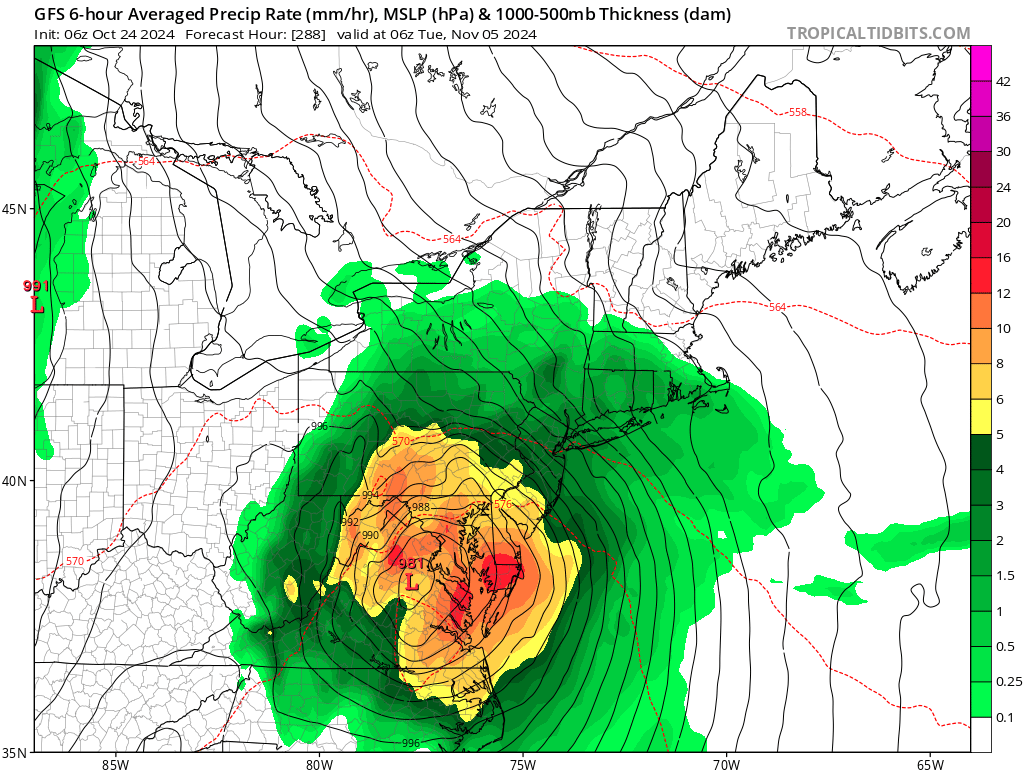
MY election day storm is back LOL

- 1,105 replies
-
- 2
-
-
- tropics
- heavy rainfall
- (and 5 more)
-
That soil moisture map sucks. Soil moisture does not follow the Delaware River. That is a fact. Everyone is in the zero percentile right now except the higher elevations as was evident in my post weeks ago about a backhoe near my yard digging 4-6 feet down and the soil was powder
- 1,105 replies
-
- 1
-
-
- tropics
- heavy rainfall
- (and 5 more)
-
woo hoo sprinkles showing up on the radar. Might get enough to spot the car windows with concrete pollen and dust. By the way NJ is in a drought watch However PADEP has their heads buried in the sand. So those hydrologists are out of their minds. They will not be satisfied until Green Lane and Blue Marsh lake reservoirs are empty and the Delaware River is full of salt water. Local municipal water companies are already requesting the public to conserve
-
The NE High over southern Canada will not move period. Every cold front that comes through disspates as it approaches this stubborn HP. The GOM is shutoff from moisture being transported in reaching the fronts from SE. The hurricanes and the southern jet stream are steering th low pressures systems in a zonal pattern right off the Carolina coasts and not allowing them to come NE along the east coast. We are stuck in the middle of all of this. I see no changes until an Alberta clipper moves this current HP out of the way or a Hurricane comes our way. Either way, I see no precip until this happens.
-
this is what I thought would hit us- but eh drought continues. Yes, the first measurable precip will fall as rain changing to snow after Nov 15
-
3 feet of snow for the smokies on the 0Z run tonight for election day. What is the GFS smoking? And we mange only some drizzle of course LMAO
-
here is my proof on local conditions by LCA. By the way LCA supplies the entire water supply for just not Lehigh County and Allentown bu the entire NE part of the country. Samual Adams, Niagra, Deer Park, Peierre, Ocean Spray, Desanti, Coke , Dr . Pepper/Keurig etc all use LCA wells to provide you bottled water products and your beverages. Bet you guys did not know this. And the Little Lehigh in my backyard supplies the entire city of Allentown and it suburbs and is the cleanest trout fed limestone stream for a major metro area in the entire country. https://www.lehighcountyauthority.org/wp-content/uploads/2024/10/LCA-WeeklyReport-DroughtMonitoring-Dashboard-101624.pdf https://www.lehighvalley.org/news/data/lehigh-valley-a-state-leader-in-beverage-manufacturing-companies/
- 1,105 replies
-
- 1
-
-
- tropics
- heavy rainfall
- (and 5 more)
-
after looking at the last two GFS runs, these ignoramuses at PADEP better issue a drought warning and soon. There is no precip for at least two more weeks as the election day rains as well as the pre-halloween fantasy snow storm have all but dissapperered from the LR GFS models. I am telling you all that drought is becoming real serious situation now. Any dry cold front that comes through will also trigger wildfires bigtime in the poconos as well as the Pine Barrens too. Wells are drying up quickly. The well drillers in our area have got to be balls to the wall busy right now. I expect limestone springfed streams to start going dry in our area. The Litttle Lehigh in my backyard will be going dry real soon and that is a huge problem for the 300,000 people in the LV. People are still watering their vegetation as well lawns. The plants and shrubs have not gone into winter dormacy. Landscapers are attemting to reseed and plant new vegetation and trees but without irrigation it is fruitless. By the time the rains come, the soil temps will be too cold for the seed to germinate and the new plantings root balls will shrivel to nothing, thus with no firm root system established. We basically have until Nov 15 to plant grass seed, yet we have no rain all the way to Nov 6. One week of precip is not going to do it folks. Here at my house , I have two nights already below 30 degrees and with at freezing temps for 4 days now, its not looking good. The soil temps are dropping quickly with no available moisture in the soil profile. Its a real desert right now as the dinural temps are swinging from 70 degrees to around freezing with humidities at 35% or less. Little frost and no dew because of the little low humidities are making the germination process even a worse situation.
- 1,105 replies
-
- 2
-

-
- tropics
- heavy rainfall
- (and 5 more)
-
At this point, I will take anything that brings precip LMAO. White rain as temps will be in the 70's days before
- 1,105 replies
-
- 1
-
-
- tropics
- heavy rainfall
- (and 5 more)
-
This getting real serious yet no drought warning issued- what is wrong with PADEP? https://www.wfmz.com/news/area/berks/reading-area/mandatory-water-conservation-notice-issued-for-reading-area-customers/article_29a0c5e2-8cc9-11ef-aec9-3752714160ee.html#tncms-source=More-from-newsroom-(right-column)
-
down to 29 here in Macungie last night. Heavy frost and a killer freeze. Still no rain in sight. The drought moniort says we are in a moderate drought today. BS I say. The stream levels are down bigtime and wells are going dry. Severe IMHO. Biggest take away, zero chance of the burned up lawn now recovering from this wicked dry spell until next spring. Landscapers will be busy next spring reseeding lawns from the damage done by this years high and dry fall weather.
-
this guy below in the link does a fairly decent job of agreeing with me for a better explanation of how I think this winter will pan out
-
miller b's forming at the tail end of the clippers as they stall out coming toward us and form a transfer low off the MId Atlantic coast. Lots of ice and wet snow events.
-
When the township replaced the 24 inch stormwater pipe about two weeks, the soil profile was literally dust as it was so dry. In all my years, I have never seen the soil profile that dry 4 to 6 foot down. I am reiterating PADEP has their head up their a** for not declaring a drought warning. Keep on watering people, as more wells go dry and the base flows disappear in the limestone geology streams. The shale stream beds are already dry.
-
the tide will change- mark my words. I have it seen happen several times in the last 30-40 years. La Nina is fading quickly. Evidence is with the GOM moisture becoming an issue in the last few weeks and the jet stream that fed and steered the living hell out of the last two hurricanes over the SE USA that was way too far south for this time of the year. Once the neutrality pattern sets in, the Arctic clippers will return with a vengeance and so will the cold temps.