HeadInTheClouds
-
Posts
1,691 -
Joined
-
Last visited
Content Type
Profiles
Blogs
Forums
American Weather
Media Demo
Store
Gallery
Everything posted by HeadInTheClouds
-
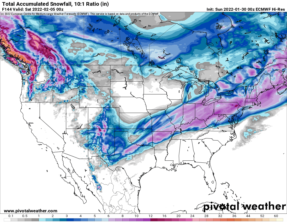
 For NYC metro and Long island yes, but for well N and W Ukie has us changing to frozen after midnight Thursday night. Hoping for sleet/snow rather than ice.
 -
No doubt, Any ice is a problem. I'm worried that some areas are going to get .50 or more of ZR. We just don't know where yet. I think GFS is too cold and CMC is too warm, using a blend of GFS/Euro/CMC is prudent at this time.
-
When I said somebody is going to get a serious ice storm I didn't mean NYC in particular and the 1 inch is likely way overdone. You are right though, right now N and W most likely and I'm 80 miles north so I'm concerned.
-
The only thing that was noticeably different was it backed off on icing over southern Jersey. It was still very aggressive north of there. I still don't believe the 1 inch of ZR in NYC metro although somebody is going to get a pretty bad ice storm.
-
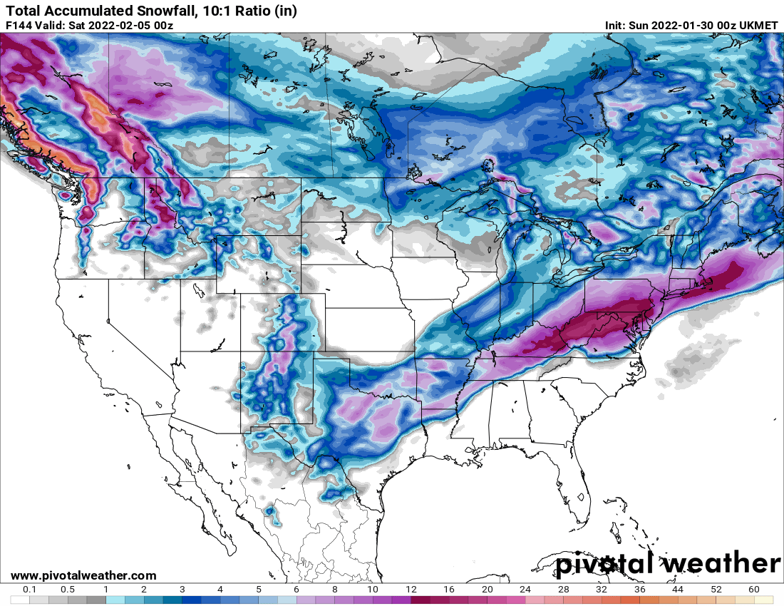
GFS and Ukie still cold and CMC trended slightly colder.
-
You got that right. Im not sure if it's right but I hope so. The GFS tends to be stubborn when it locks onto something but then eventually caves to other guidance. It did that with the last storm.
-
The farther north and west you are the better chance you have with this one. I'm 20 miles north of 84 so hoping for some snow after initial rain, then sleet/ZR. We will see.
-
Maybe even Wednesday night. The Nam was atrocious in it's long range with the last storm.
-
The front and wave or waves have plenty of moisture associated with this setup. The big question with this is how quickly the cold air pushes south and what precip type is the result and where. That is complicated and has not been resolved yet.
-
That depends on where you live. Im north of 84 and it gives me plenty of ZR and sleet. Like I said its a battle and a long way to go on this one but I wouldn't be surprised if models continue to trend colder.
-
GFS was a dumpster fire also. It had hardly any snow for the area, including Long Island, 48 hours before snow began.
-
That artic high means business and models starting to pick up on it. Ukie was the colder outlier but ICON FWIW has trended significantly south and GFS also. GFS verbatim gives me a little rain to sleet to heavy snow. It's a battle and we are in the battle zone.
-
That icing could be serious up here along 84 and north.
-
12Z Cmc has also trended colder. Give area frozen precip after initial rain.
-
The 00z Euro and Ukie are significantly different and colder from the GFS and both bring good snows to the area. 12z GFS has trended more south and wave is weaker which is good if you want snow.
-
And this was less than 48 hours before snow began. Just brutal.
-
Definitely bears watching. GFS and CMC are mostly rain but Euro and Ukie are both colder and have significant snow.

-
He is enjoying his foot but it's usually in his mouth after his weather forecasts.
-
This was the GFS performance for this storm.
-
One thing that is always trending is you being wrong in the end.
-
January 28/29 Blizzard Observations/Discussion/Nowcasting
HeadInTheClouds replied to Northof78's topic in New York City Metro
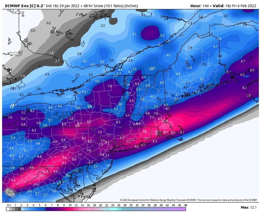
CP, somebody said that was for today and the total for the storm was closer to 9. That might even be low. Im not sure. -
Exactly. And then try to tell us how the next potential storm is not going to work out. Rinse. Lather. Repeat.
-
He must be talking about another GFS model in an alternate universe because the one that I was tracking with this storm put on an embarrassing display and as usual caved to the other models late in the game.
-
What eastward extreme? Parts of NYC metro got a foot of snow when that POS model was only giving a snowstorm to the Canadian Maritimes 48 hours before game time. It was absolutely God awful with this storm. One of the worst performances ever.