OrdIowPitMsp
-
Posts
2,810 -
Joined
-
Last visited
Content Type
Profiles
Blogs
Forums
American Weather
Media Demo
Store
Gallery
Everything posted by OrdIowPitMsp
-
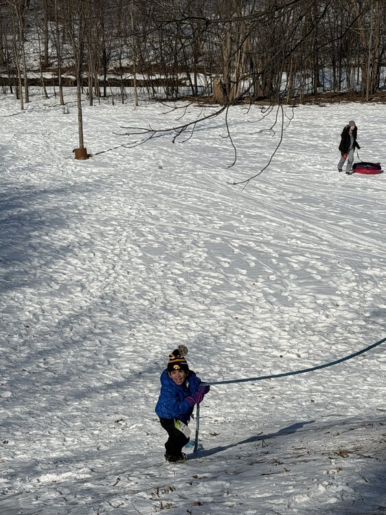
Perfect day for sledding. Kid was acting like the rope used to climb up the hill was mountain climbing. Loads of fun.
-
I was thinking about this the other day. It’s been bad across the plains. Omaha - 6.5”, Rapid City - 7.7”,
-
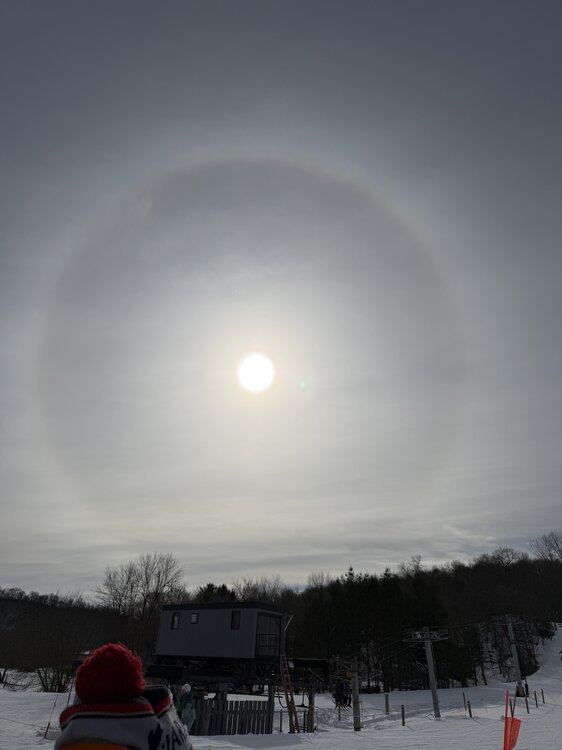
Legit Sundog at the ski hill today
-
Made it to 37 here. Was able to take the sweatshirt off for a short 10min stint today.
-

Winter 2025-26 Medium/Long Range Discussion
OrdIowPitMsp replied to michsnowfreak's topic in Lakes/Ohio Valley
Just checked. March averages the most 6” and 8” storms at MSP, and is our second snowiest month. -
Winter 2025-26 Medium/Long Range Discussion
OrdIowPitMsp replied to michsnowfreak's topic in Lakes/Ohio Valley
We sure do. I still think we are paying for winter 22/23’ but we tend to get juicy storms in Spring. -
Winter 2025-26 Medium/Long Range Discussion
OrdIowPitMsp replied to michsnowfreak's topic in Lakes/Ohio Valley
MSP is 1.6” below average and nothing on the horizon. March will be ours. -
The next week is going to feel fantastic, and likely obliterate our meager snowpack.
-
1.4” of snow at MSP today. 29.3” season to date.
-
January 2026 at MSP: Average temp 13.7F (2.5F below average) 12 lows below zero (2 at zero) 2 daily highs below zero. 4.1” of snow - 28 days of at least 1” snowcover at the airport. (Mby had continuous snowcover)
-
Little bit less then an inch here this morning to cover up the frozen dog turds and freshen up the pack. Best action here in weeks
-
Down to 0 at MSP this morning.
-
MSP eeked out a low of -1 this morning. We’ve now had a low temperature at or below zero for 14 of the past 15 days.
-
Winter 2025-26 Medium/Long Range Discussion
OrdIowPitMsp replied to michsnowfreak's topic in Lakes/Ohio Valley
I’ll bite. I enjoy it immensely. I would much rather work outside in a week of -10/+10 temps then 90+ with 70+ dews. I’m outside 80% of the time with my job so I have experience in all weather Minnesota can throw at me. I’m a diehard skier too so that’s an added reason I love deep winter. I’m ready for a pattern shakeup so we can get some fresh snow. There has only been one calendar day snowfall of 1” this month at MSP. I think it’s kinda strange how much you bitch and moan about the weather in a region you don’t frequently visit, but hey it’s a free country. -
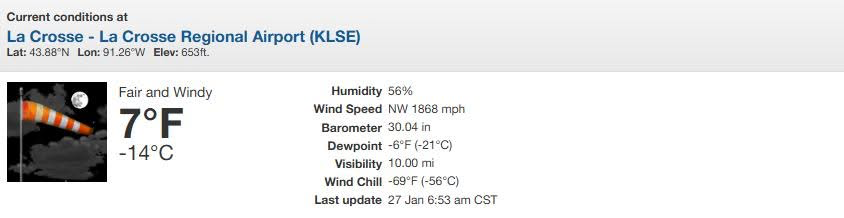
Got a little windy in La Crosse last evening.
-
MSP got to -13 last night.
-
Temp has risen to 0 at MSP. The airport was below zero for 67 hours.
-
1/24-1/25 Major Winter Storm - S. IL, IN, and OH
OrdIowPitMsp replied to A-L-E-K's topic in Lakes/Ohio Valley
MSP crew joining the fun.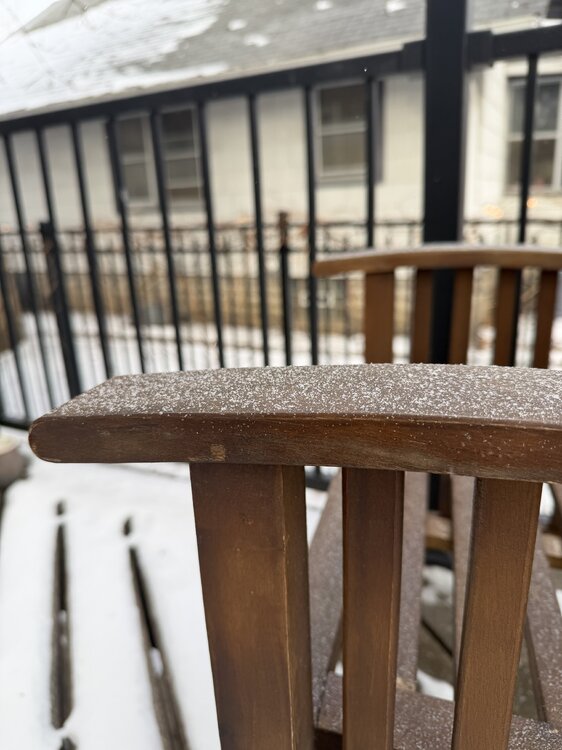
-
Getting some light pixie dust. It’s warmed up to -4 so the atmosphere is primed.
-
MSP only dropped to -9 overnight. We should pop above zero today after ~65-70 hours below zero.
-
High of -2 at MSP today.
-
-15 at MSP
-
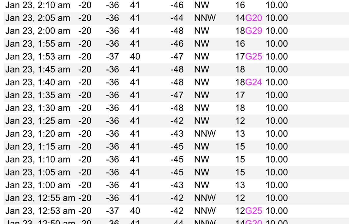
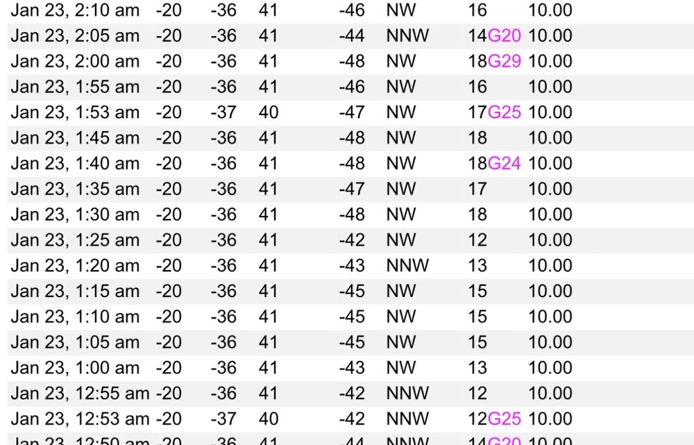
Four instances on the non-hourly 5min obs.
-
Minneapolis had a high of -9 today.
-
Coldest windchill at MSP was -48 overnight.