OrdIowPitMsp
-
Posts
2,803 -
Joined
-
Last visited
Content Type
Profiles
Blogs
Forums
American Weather
Media Demo
Store
Gallery
Everything posted by OrdIowPitMsp
-

Winter 2022/23 Medium/Long Range Discussion
OrdIowPitMsp replied to Chicago Storm's topic in Lakes/Ohio Valley
This is starting to feel like our last big dog all over again with models spitting out crazy totals. I guess that means final call imby 12.4” -
Models have come into good agreement on a general 2-4” tonight across the area. It’s gonna be water logged concrete.
-
NAM is falling in line with the globals, Could see a heavy wet 4-7” fall across the metro tomorrow night and Monday. Snow liquid ratios may only be a little higher then what impacted MI yesterday. There’s a very snowy look into the latter half of next week. Go figure I’m flying out to Colorado on Thursday. I’ll have to bribe my neighbor with beer to shovel my sidewalk if it comes into fruition.
-
It’s nice seeing it getting light out earlier in the morning, meanwhile a classic battle between globals and hi-res models regarding the precip type here tomorrow night/Monday is unfolding. 0.50” of cold rain or 6” of snow. I know which one I’m rooting for.
-
These reports are awesome. Enjoy everyone. Cirrus soaked skies up here.

-
You’d think there’s not much going on just looking at this map.
-
The NAM was the only model showing a NW solution for the current storm impacting IN/MI and that failed badly. Let’s hope it has a repeat performance for us.
-
Looks like we’ll be riding the edge of rain/snow on this one. GFS puts 6-9” down here but it’s close. Either way nice to have some active weather to track.
-
I think it’ll be a slop storm for the metro similar to this last one, with healthy snows just to the north. Hopefully I’m wrong but seems like we are on the wrong side of the cold air line.
-
How many times has Detroit gotten 6”+ of snow on the same day Minneapolis has a high of 40 or above. There is no cold air to be found.
-
If recent trends this winter hold true we should be entering the “substantial drying phase” of the model watching.
-
My body thinks I’m 85, I can’t sleep past 5:30am.
-
Still have 6-7 weeks of realistic time left on the clock this winter.
-
C’mon man this is a joke right? We haven’t had wall to wall cold, but you aren’t gonna have 70”+ of snowfall around these parts with polar air suppression all winter long. 100% snow cover in DJF, much of it double digit depth. Multiple 12”+ storms, and had some days that stayed below zero. It’s been a weird ice fishing season with deep snowpack that insulated the lakes early and kept ice from getting as thick as years past, but there’s still plenty of ice houses out there. This is an A+ winter, I work outside so I can do without the punishing cold we usually get.
-
Solid moderate snow in Cambridge MN. 2” down, less then an inch of slop in Minneapolis.
-
Oh the southern edge of the snow band this morning. Picking up a wet sloppy inch. My job site up in Cambridge MN will pick up 3-4” today. March comes in like a lion.
-
https://en.m.wikipedia.org/wiki/Hard_Winter_of_1880-81
-
Today I learned that even nerdy weather boards have weirdos. (Besides the nerd stuff) Great to have ya back @Stebo
-
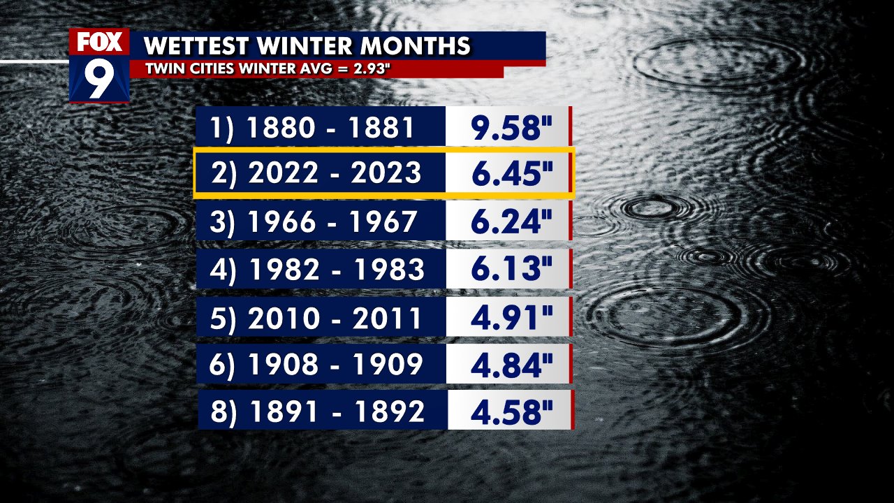
2nd wettest meteorological winter on record. Going to be interesting to see how this translates to spring flooding. It’s been a heck of a winter, however 1st place is on a whole different planet.

-
Just remember cut model output qpf by 30%. It’s been this winters trend.
-
Looks like they’ve been posted, kinda surprised Hennepin and Ramsey counties were included, I’d have gone a county north but they probably want to hammer the message to the core of the metro.
-
-
Winter 2022/23 Short/Medium Range Discussion
OrdIowPitMsp replied to Chicago Storm's topic in Lakes/Ohio Valley
At this point in the year we need to start stat padding to keep our snowpack from decaying. -
Minneapolis received 0.47” of precipitation today. Glad this one trending down.
-
Everyone smoke a bowl and calm down.