

OrdIowPitMsp
-
Posts
2,803 -
Joined
-
Last visited
Content Type
Profiles
Blogs
Forums
American Weather
Media Demo
Store
Gallery
Everything posted by OrdIowPitMsp
-
3” in Minneapolis, and puking snow in Aspen CO.
-
Taxiing for takeoff and the snow just started.
-
Looks like 3-5” across the twin cities today. Haven’t been tracking this one as closely as usual, heading to the airport for a week in Colorado and the remnants of an AR event hitting this weekend have my attention.
-
Mood flakes+ all day added up to 0.4” by 6pm bumping Minneapolis up to 75.1” on the season. We had a decent band work through between 630-8 that should add some more to the total. As a harbinger to the date on the calendar very little accumulated on paved surfaces until the sun set.
-
My dad calls Minnesota “diet Canada”
-
Working in @mnchaserguy neck of the woods at hwy-65 and 99th St today. It’s been solid white rain for a few hours. Maybe a couple tenths of new accumulation.
-
I’m with @A-L-E-KDallas climate sounds terrible to me. Flip the number of days above 100 with days below 32 and maybe we can talk.
-
We’ll take all we can get. The lakes need to recover from 2 summers of extreme drought.
-
2008 was relentless. I was working in the Minocqua WI area that summer. RIP Lake Delton.
-
Probably can cut these totals in half, unless this is counting the weekend snow potential. (Which it doesn’t)
-
Can’t always be right. I’ll take my WWA and be happy.
-
I’ve got an 8am flight Thursday so a weaker storm is fine by me. I just want us to break the seasonal snow record.
-
Looks like MPX isn’t messing around with a WSW already posted for 4-7” meanwhile the graphic shows 6-12”
-
North, South, East, West. There really isn’t a direction this thing can trend away from MSP. Ready 2b buried
-
Big fluffy parachutes have been falling all morning. Adding a few tenths to the total.
-
The drive from Des Moines to Minneapolis is only 3.5 hours but it’s a whole different world up here. I talk to my brother in DSM often and they’ve had plenty of days in the 40s/50s lately. We’ve still got 12”+ of glacier that isn’t going anywhere.
-
-
Classic spring paste job. Looks like 3-3.5” at my house. The southwest suburbs hit the jackpot with 6”+ totals.
-
Its just massive clumpy dendrites coating everything. Guessing 1.25-1.5” so far, looks like the convection is staying down in Iowa.
-
Yeah pretty solid snow imby right now. Fat clumpy flakes sticking to everything. The forecast for days was calling for rain changing to snow, the HRRR was even showing that all day but it’s all been frozen since onset.
-

Winter 2022/23 Medium/Long Range Discussion
OrdIowPitMsp replied to Chicago Storm's topic in Lakes/Ohio Valley
My memory was hazy and my data was a little off. Here’s a graphic from the great winter of 13/14’ showing the top 10 longest snow cover streaks for Minneapolis.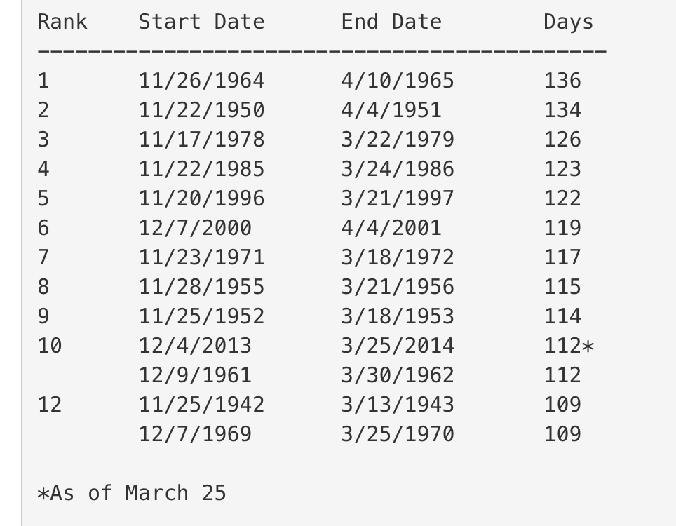
-
Hoping it makes it way up here. NWS seems pretty bullish on thunder chances this evening. Hopefully I can get some good flashes on the security camera during the SN+ that rolls through.
-
It’s a trick due to how the radar sends out its waves and the curvature of the earth. https://www.fox9.com/weather/the-mystery-behind-the-snow-hole.amp
-
Winter 2022/23 Medium/Long Range Discussion
OrdIowPitMsp replied to Chicago Storm's topic in Lakes/Ohio Valley
The all time record for consecutive days of snow cover is 137 days for Minneapolis. 107 gets us into the top 10. We are going to keep needing these refresher events as the sun gets stronger. The big difference I’ve noticed here versus growing up in Lake County IL is even on the days that get into the upper 30s/low 40s we melt off much less snow due to the sun angle at this latitude.

