OrdIowPitMsp
-
Posts
2,790 -
Joined
-
Last visited
Content Type
Profiles
Blogs
Forums
American Weather
Media Demo
Store
Gallery
Everything posted by OrdIowPitMsp
-

April 2023 General Discussion
OrdIowPitMsp replied to PositiveEPOEnjoyer's topic in Lakes/Ohio Valley
HRRR keeps shifting the heaviest band of snow west. Now the main accumulation is almost completely west of the metro. Last minute Chaos! -
April 2023 General Discussion
OrdIowPitMsp replied to PositiveEPOEnjoyer's topic in Lakes/Ohio Valley
Wow. Not happening, but seeing it from the euro in this range is eye opening to say the least. The metro is under a WWA for 2-4” my P&C is 4-7” however. -
April 2023 General Discussion
OrdIowPitMsp replied to PositiveEPOEnjoyer's topic in Lakes/Ohio Valley
Area Forecast Discussion National Weather Service Twin Cities/Chanhassen MN 1108 AM CDT Sat Apr 15 2023 . UPDATE... Issued at 1108 AM CDT Sat Apr 15 2023 12z guidance is coming in much more aggressive than previous runs regarding accumulating snow potential. We are continuing to monitor the situation as more guidance comes in. But as of now, counties 30- 40 miles in either direction from the I-35 corridor is the main area of concern with significantly increasing confidence of winter weather headlines being issued this afternoon. -
April 2023 General Discussion
OrdIowPitMsp replied to PositiveEPOEnjoyer's topic in Lakes/Ohio Valley
45/42 here with light rain. -
April 2023 General Discussion
OrdIowPitMsp replied to PositiveEPOEnjoyer's topic in Lakes/Ohio Valley
It’s going to catch a lot of people off guard tomorrow if the NAM verifies. We just need the low to meander a bit further west and the metro will cash in big time. -
April 2023 General Discussion
OrdIowPitMsp replied to PositiveEPOEnjoyer's topic in Lakes/Ohio Valley
Clearly the NWS has no idea whether or not to trust modeled snow accumulation for tomorrow. -
April 2023 General Discussion
OrdIowPitMsp replied to PositiveEPOEnjoyer's topic in Lakes/Ohio Valley
Cold front came through, it’s down to 63. Already colder then it’s been since Tuesday morning. -
Hello fellow lightning strike survivor. The tent I was sleeping in got hit while camping in the Porcupine Mountains in June 2001. I have a scar where my watch was sitting on my wrist.
-
April 2023 General Discussion
OrdIowPitMsp replied to PositiveEPOEnjoyer's topic in Lakes/Ohio Valley
Minneapolis needs 9” to break the record and 5.3” for second place. Duluth needs 3.8” to break the record and 0.1” for second place. -
April 2023 General Discussion
OrdIowPitMsp replied to PositiveEPOEnjoyer's topic in Lakes/Ohio Valley
It is the NAM so take it with a grain of salt….but 4-6” of snow after multiple 80 degree days would be something. It’s definitely going to snow Sunday, the question is how much. -
April 2023 General Discussion
OrdIowPitMsp replied to PositiveEPOEnjoyer's topic in Lakes/Ohio Valley
Bingo, we are taking soil samples for a proposed residential development. -
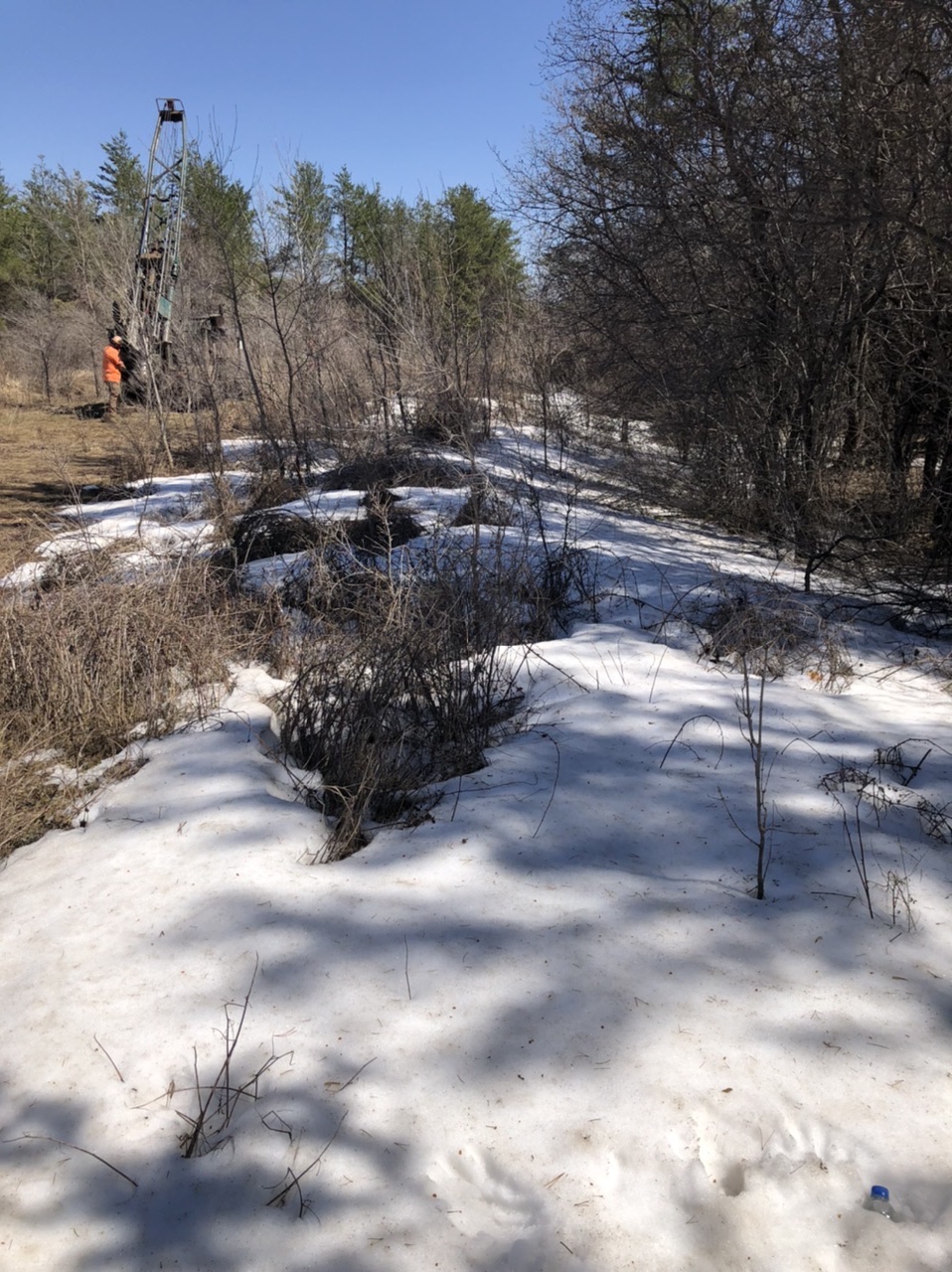
April 2023 General Discussion
OrdIowPitMsp replied to PositiveEPOEnjoyer's topic in Lakes/Ohio Valley
My farmers tan is almost in midsummer form after a few days working in this heat. This photo was taken today in a soon to be suburbanized part of Rosemount MN when it was 82 outside. Still some pockets of deeper snow in spots. Bonus points to anyone who knows what kind of drill rig that is in the background.
-
April 2023 General Discussion
OrdIowPitMsp replied to PositiveEPOEnjoyer's topic in Lakes/Ohio Valley
Minneapolis got up to 88 again this afternoon, breaking the record high of 85. The last remaining ice on Lake Nokomis a few blocks from my house melted out today. 9 days later then the long term average. -
April 2023 General Discussion
OrdIowPitMsp replied to PositiveEPOEnjoyer's topic in Lakes/Ohio Valley
One more day of record heat and then models are trying to give us either a cold rain or accumulating snow Sunday. Turned on the AC this morning, trying to get ahead of the heat. Our house got up to 82 with windows open yesterday and only cooled off to 74 overnight. -
April 2023 General Discussion
OrdIowPitMsp replied to PositiveEPOEnjoyer's topic in Lakes/Ohio Valley
It’s 88 degrees in Minneapolis right now. Previous record was 83. first tick of the season on my leg today. -
April 2023 General Discussion
OrdIowPitMsp replied to PositiveEPOEnjoyer's topic in Lakes/Ohio Valley
It’s ridiculous outside this morning, still 64 at 6am. I’m going to have to turn my AC on today. Todays record high is toast. -
April 2023 General Discussion
OrdIowPitMsp replied to PositiveEPOEnjoyer's topic in Lakes/Ohio Valley
Minneapolis Spring 2023 First 50: April 2nd First 60: April 9th First 70: April 10th First 80: April 11th -
April 2023 General Discussion
OrdIowPitMsp replied to PositiveEPOEnjoyer's topic in Lakes/Ohio Valley
81 degrees in Minneapolis. Heat Island flexing its muscles. I can see thermals (or the cold equivalent) rising off the still frozen lake. -
April 2023 General Discussion
OrdIowPitMsp replied to PositiveEPOEnjoyer's topic in Lakes/Ohio Valley
Grass is starting to green up in areas that had 4+ months of snowcover just days ago. Already 75 here, 80 is within reach. -
Spring 2023 Medium/Long Range Discussion
OrdIowPitMsp replied to Chicago Storm's topic in Lakes/Ohio Valley
Yes please. We are so close to the all time record. Might as well break it and the century mark. -
April 2023 General Discussion
OrdIowPitMsp replied to PositiveEPOEnjoyer's topic in Lakes/Ohio Valley
First 70 of the year in Minneapolis with a high of 72. Looks like we’ll tag 80 by Wednesday with record highs possible. What a turnaround! -
April 2023 General Discussion
OrdIowPitMsp replied to PositiveEPOEnjoyer's topic in Lakes/Ohio Valley
Overachieving here too. We are up to 66 after a forecast high of 61. First temperature above 60 in Minneapolis since November 10 It felt really good to shovel all the remaining snow off the deck. -
April 2023 General Discussion
OrdIowPitMsp replied to PositiveEPOEnjoyer's topic in Lakes/Ohio Valley
One last chilly morning in the low 20s. Warmup starts in earnest today. Kinda looking forward to it tbh. -
April 2023 General Discussion
OrdIowPitMsp replied to PositiveEPOEnjoyer's topic in Lakes/Ohio Valley
I think my yards snowpack will be gone after this weekend.
-
April 2023 General Discussion
OrdIowPitMsp replied to PositiveEPOEnjoyer's topic in Lakes/Ohio Valley
I found some areas were still knee deep. I was impressed to say the least.