OrdIowPitMsp
-
Posts
2,791 -
Joined
-
Last visited
Content Type
Profiles
Blogs
Forums
American Weather
Media Demo
Store
Gallery
Everything posted by OrdIowPitMsp
-
I’ve seen more thunderstorms at 40 then 100.
-
Nary a drop of rain in Minneapolis, meanwhile over an inch down here in Okoboji.
-
Working in the Lake Okoboji area of NW Iowa today and tomorrow. Might actually have a storm roll through here tonight.
-
As the theme of the summer continues, convection fired off east of town.
-
High of 93 today. Waiting for the convection to fire just to my east today.
-
Going to have to close windows and fire up the AC today. Calling for a high of 87 here, probably break 90 tomorrow before the cold front and associated clouds approach. 1.50” of precipitation since June 1st. Dust Bowl’n. Really hoping we score on some convection tomorrow.
-
We are now in the warmest part of the year based on average highs in Minneapolis.
-
Oh man I gotta go find this thing now. July snow in Minneapolis!
-
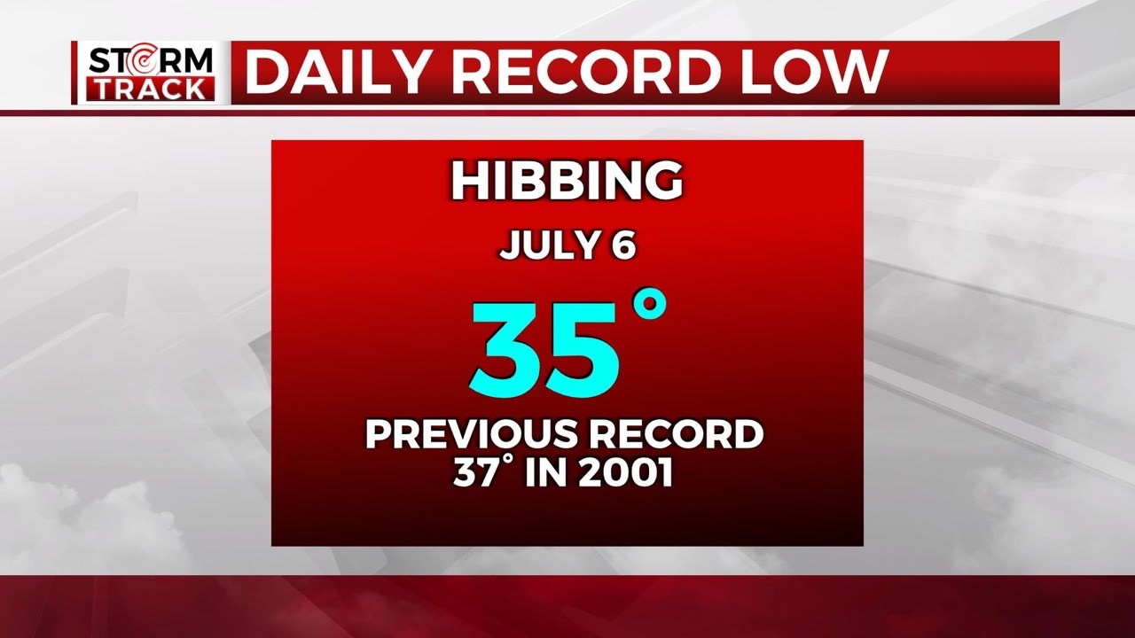
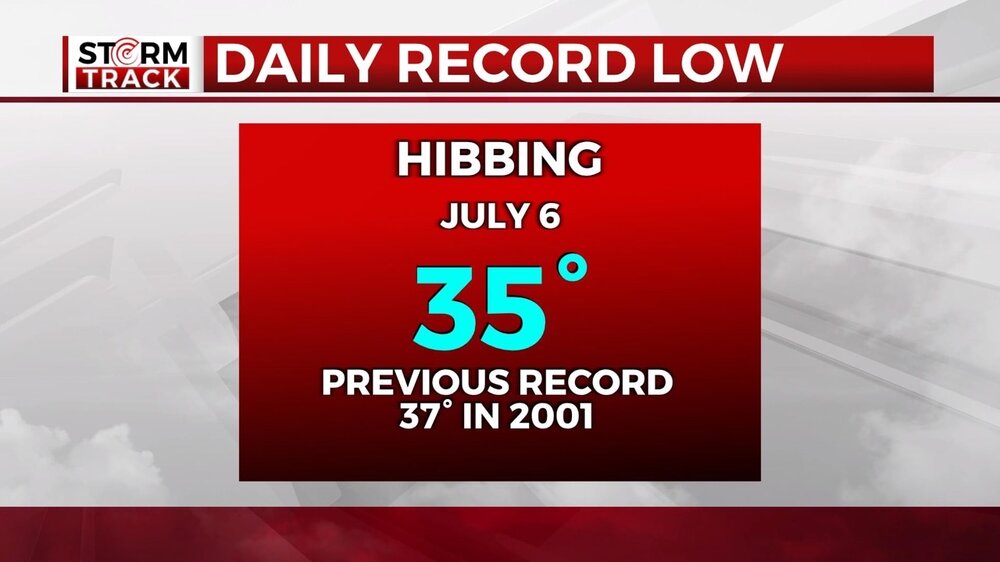
Cold start to the day on the Iron Range.
-
FTFY If I could press Control-C today for all of summer I would do it in an instant.
-
Overnight low of 55, perfect night to give the AC a break and open windows.
-
75/48 right now. Summertime perfection. It’s going to drop into the upper 40s away from the urban core tonight.
-
0.57” of much needed rain this morning. Hopefully more with a good Fourth of July light show this evening. Got caught in a pretty intense downpour near Osseo WI on Interstate 94 a bit ago. Tons of cars pulled over with flashers on.
-
95/66 in Minneapolis currently. Hottest day of the year. 75/64 at the Chicago Botanic Gardens where I spent the last several hours.
-
Lots of my friends who own homes across the southern/western Chicago metro are dealing with flooded homes today.
-
It’s rained more here where I’m staying in Bannockburn Illinois since Saturday morning then Minneapolis has seen since May 1.
-
June 2023 finished with 0.93” of precipitation which is 2nd driest all time behind only 1988. The average temperature of 75 degrees is 5.3 degrees above normal. Hot and smoky is the how I’ll remember June 2023
-
More by you yesterday then all month in Minneapolis. The airport is at 0.93” for June and it looks like we won’t see anymore which would edge out 1912 for 2nd driest on record behind 1988. We’ve also achieved 90 today with the smoke clearing out allowing for full sunshine and blue skies.
-
High of 86 here today. The thick smoke worked to stabilize the atmosphere and prevent any storm development in the metro. Is it supposed to be smoky in N. Illinois this weekend? I’ll be in Chicagoland Friday-Tuesday.
-
For fear of sounding like a broken record, strong smoke smell and haze here today. Welcome to the new normal I guess.
-
Getting a faint smoke smell in the air here today. AQI isn’t horrible but the presence of some smoke is noticeable.
-
0.78” of precipitation over the weekend in Minneapolis. Takes the drought pressure off for about 5 days.
-
Wrap around showers this morning. Cooler temps and moisture in the air. Oh what a feeling
-
Finally merciful rain. It’s not much. Less then half a weeks worth, but it’s something. 2nd driest June still in the cards.
-

2023 Short/Medium Range Severe Weather Discussion
OrdIowPitMsp replied to Chicago Storm's topic in Lakes/Ohio Valley
Strong storms building south of town. Hoping it can build my up way before moving east.