

OrdIowPitMsp
-
Posts
2,791 -
Joined
-
Last visited
Content Type
Profiles
Blogs
Forums
American Weather
Media Demo
Store
Gallery
Everything posted by OrdIowPitMsp
-
Up the shore from @Brian DDefinitely a couple weeks early this year.
-
Overnight low of 45, coldest temperature in Minneapolis since May 20. Patchy frost outside the UHI
-
Frost advisories for northern Minnesota. There will be patchy frost outside the metro area tonight as well. Warms up quick late week though.
-
Counting my lucky stars. A small storm dropped 0.22” imby overnight.
-
Only mustered 0.06” here over the weekend. That’s also our rainfall total since August 14. Bone dry is an understatement
-
Typical early autumn weather today. Scattered showers and mild temps. Won’t amount to much at all, maybe 0.25” but a nice change of pace to see something falling from the sky.
-
The lake by our house was steaming this morning. Car thermometer read 48 when I pulled into work.
-
We managed a high of 64 today in Minneapolis. Quite the change from Monday.
-
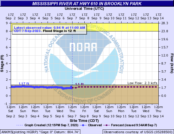
Mississippi River north of the twin cities is near record lows. Currently below the low water threshold.
-
Just a couple sprinkles here. Basically will be 30+ days without any precipitation. Beginning to see more trees starting to accelerate the leaf drop. Quite the airmass change. Went from peak summer to mid fall overnight.
-
Minneapolis was able to escape triple digit heat this year. Topping out at 99 today. Brainerd clocking a 102 well north of the twin cities and the start of cabin country was eye catching. Very steamy morning today on Michigan Ave, dews were running about 10 degrees higher then Minneapolis when we left the hotel. Great views from floor 39.
-
I think we break 100 on Sunday. The relatively dry airmass should help temperatures overachieve compared to the last heatwave. Lucky me, I’ll be in Chicago this weekend for a wedding and miss the misery.
-
Neighbors mature white oak tree has succumbed to a suspected case of “Twolined Chestnut Borer” No doubt that 3 summers of drought caused the mortality. I’ll post detailed stats this weekend but J/J/A will finish with 5.79” of precipitation, against an average of 12.86” which is only 45% of normal.
-
GFS showed 105-115 for Minneapolis during the last heatwave. We never made it above 98. I do think we have a better chance of breaking 100 this time around with much lower dews.
-
Why do you post the GFS, it’s proven over and over again to have a 5-10 degree warm bias. Heat does look to stick around for the first half of September.
-
A winter like that would probably translate to 40s/50s through Memorial Day.
-
This sounds lovely right now tbh. There hasn’t been any precipitation here since August 14 with nothing on the horizon.
-
Theme of the summer, smoke is back.
-
Dang Bo, I thought it was autumnal here with our breezy high of 72 today, but you are six weeks ahead of us. Great to be able to open windows again.
-
Except here in Minneapolis where we unexpectedly hit 90 again today.
-
82/68 here. The difference in how I feel working outside between yesterday and today is remarkable.
-
73/66 and some fog. Still elevated dews but it feels a lot better out here today.
-
The official high today in Minneapolis is 98, same as yesterday. Impressive late season heat wave. Tomorrow will feel refreshing with a forecasted 89.
-
Congratulations palm guy!
-
Nice dry air up in Minneapolis. 97/72/106


