

OrdIowPitMsp
-
Posts
2,791 -
Joined
-
Last visited
Content Type
Profiles
Blogs
Forums
American Weather
Media Demo
Store
Gallery
Everything posted by OrdIowPitMsp
-
Yup, decaying showers brought the LLJ to the surface. Flying Cloud Airport in Eden Prairie reported a 62mph gust. Numerous reports of power out in the western suburbs. But hey we recorded a T of rainfall.
-
Watching this line of rain dry up as it moves towards the metro is depressing. We’ll be lucky to double our June total today at this rate.
-
Minneapolis recorded its 10th 90 degree day of the season today. Hopefully the last for awhile. Brief shower just deposited 0.02” which brings the June total up to a hefty 0.12” Really hoping this weekends rains deliver the goods.
-
Minneapolis has achieved our 9th 90 of the year today.
-

Summer 2023 Medium/Long Range Discussion
OrdIowPitMsp replied to Chicago Storm's topic in Lakes/Ohio Valley
I sure hope so. Sitting at 0.26” of precipitation since May 15th. -
Nope, just an all out nerd on anything earth science/natural world based. I was living in Illinois when the EAB decimated the ash population, and did extensive research on the subject since my childhood backyard was nothing but ash trees. I’ve watched the cycle begin to repeat itself up here in MN the past several years.
-
Hopefully it’s not lots of lower trunk growth, that could be a sign of emerald ash borer infection. 91 here this afternoon. 8th 90 of the year.
-
Dust storms from the SW. The melt in Colorado was accelerated this year due to dust accretion on the snow.
-
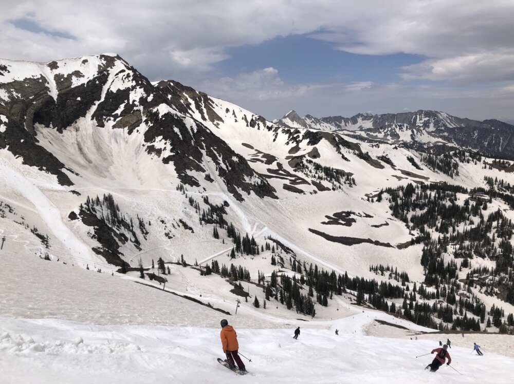
Over the weekend I was in Utah visiting family and got the chance to ski on the final day of the season at Snowbird. Pretty awesome conditions for mid June.
- 210 replies
-
- 10
-

-
Pounding ice cold ones all day. Up to 91 for the high. Low 50 dews help a lot too.
-
88 in Minneapolis at 1pm. We should make a push for our 7th 90 degree day of the year.
-
I thought we were heading for a very wet summer especially after 21’ and 22’ were so dry. 2023 said hold my beer.
-
Another weekend of 0.01” of precipitation in Minneapolis.
-
We are putting 1988 to shame.
-
Setting the wrong records this summer. Next up, driest June on record. June 1988 had a paltry 0.22” of precipitation, we are at 0.09” as of 6/15.
-
AQI up to 243 locally. I’ve never seen it above 180 until today. Scary stuff
-
Getting seriously worried about mature trees if that pans out. 3 summers in a row of this can’t be good at all.
-
It’s as bad as I’ve ever experienced today. Very strong smell of smoke and I’ve got a slight headache from working outside in this. Currently 84 with 3 miles visibility due to smoke/haze.
-
Dense smoke this morning. Pretty strong stench outside. Should keep us from achieving 90 today.
-
0.26” of precipitation in Minneapolis since May 15th. May precipitation was only 30% of average. Things are getting bad quickly here.
-
High of 88 in Minneapolis today, the only saving grace was the mid 40s dews. Roadside grass has that autumn golden hue to it.
-
Maybe for you guys further east but we are roasting west of the 90th meridian.
-
Can we just nudge these cutoffs lows a bit to the west. Sitting at 82 and bone dry again this afternoon. Less then 0.10” month to date and 85-90 is a lock for the next week.
-
Pretty close to a whiff on the rains here with todays cold front. Only 0.05” fell. Up to 0.08” month to date. A nice line of showers got its act together across the south metro….go figure.
-
It’s been unpleasant working outside. Luckily so far we haven’t had the extreme 70+ dews like last summer. I’m already over this crap, and ready for coastal ridges and central CONUS troughs.


