OrdIowPitMsp
-
Posts
2,819 -
Joined
-
Last visited
Content Type
Profiles
Blogs
Forums
American Weather
Media Demo
Store
Gallery
Everything posted by OrdIowPitMsp
-

Winter 2022/23 Medium/Long Range Discussion
OrdIowPitMsp replied to Chicago Storm's topic in Lakes/Ohio Valley
Rainer on Tuesday and a near miss SE on Thursday. Bummer -
Low of 9 this morning. Not much else going on here, just a slow melt.
-
At what point do these rants just become copypasta?
-
Anything above 78 is too warm for me in the summer. Try working outside, I’ll take 0 degrees over 90 anyday.
-
Yeah I’m really suffering here. Even if we don’t see another inch of snow this winter, my grade can’t go below a B/B+
-
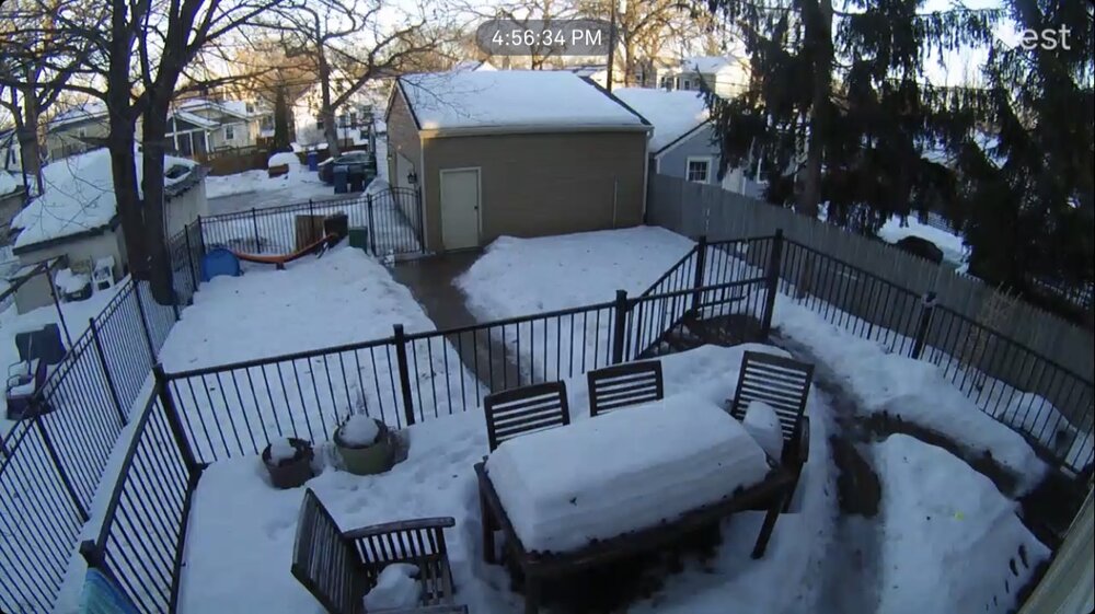
We’re fine. A midwinter thaw is totally normal. I’ll be jonesing for fresh snowfall now that the pack has a dirty look to it. Kinda cool with the melting you can clearly see the multiple layers on our table. Extended doesn’t look great but there’s still plenty of time left up here.
-
43 degrees. First time breaching 40 since November
-
It’s February 7th, 39 degrees, full sun, a foot of snow melting on the ground and I’m working outside in a t-shirt.
-
February 8-9 Should There Be a Thread For This Storm
OrdIowPitMsp replied to Hoosier's topic in Lakes/Ohio Valley
Miss south stank… -
0.1” of snow and crust yesterday. We’ll lose a couple inches to compaction and melting today and tomorrow.
-
Winter 2022/23 Medium/Long Range Discussion
OrdIowPitMsp replied to Chicago Storm's topic in Lakes/Ohio Valley
Gonna go out on a limb here and say the roof was closed during those games, and it was 68 degrees inside the stadium. -
Winter 2022/23 Medium/Long Range Discussion
OrdIowPitMsp replied to Chicago Storm's topic in Lakes/Ohio Valley
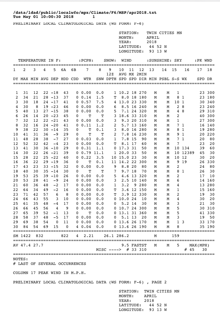
April 2018 was perfect. 26.1” of snow and palm tree weather by the end of the month.
-
Getting a solid sleet storm here. Probably mostly mixed bag in my corner of the metro but maybe a sloppy inch by morning. North of town looks to do well tonight.
-
Winter 2022/23 Medium/Long Range Discussion
OrdIowPitMsp replied to Chicago Storm's topic in Lakes/Ohio Valley
Did someone say April 2018 -
30 degrees, full sun. Beautiful day, the lake is full of ice houses.
-
We clouded over earlier then expected last night and only made it down to -13F. A few spots in the east metro touched -20F
-
Airport is reporting 10”, imby I’m measuring anywhere from 12-15” There is 3-5” of liquid equivalent locked up right now. I can almost walk on top of the snow, it’s a glacier.
-
Arctic air in full force this afternoon. Full sun and temps in the single digits. Next week the melt is on.
-
Jokes on me, it’s -15F in Benson MN this morning and we can’t get the diesel drill rig to start.
-
False, we are having a stellar ski season in central/southern MN. My hill has been 100% open for over a month and hasn’t had to make any snow. Snowmobiles are all over too. I appreciate the dedication to the bit, but you really need to move to Memphis or St. Louis, or Houston.
-
-8F is all we could muster at the airport. Looking at the suburbs and outer areas they got down to -15 to -20
-
Morning low of -8F in Minneapolis.
-
-6F for the low this morning, coldest low since -12 on December 23rd.
-
Impressive the difference across the region. I’ll go with a solid A- so far this winter. 60+ days and counting consecutive of snow cover. 15” storm right after New Years. Already surpassed our seasonal average. If we can keep the snow pack to mid March and tack on average snow from here on out this is a slam dunk A grade winter.
-
After todays snowfall Minneapolis is up to 55.5” on the season. Extended looks cold and dry, but sometimes on the backside of these arctic highs we see WAA snow. Will be a zzzzz period for sure over the next week. No extreme cold just a typical annual Minnesota cold snap.