

kvegas-wx
-
Posts
2,073 -
Joined
-
Last visited
Content Type
Profiles
Blogs
Forums
American Weather
Media Demo
Store
Gallery
Posts posted by kvegas-wx
-
-
1 hour ago, NorthHillsWx said:
It puts the NAM on its skin or else it gets the GFS/CMC/EURO/UK/RGEM again
Is that you Buffalo Bill? Fans of weather we are.
Brilliant!
-
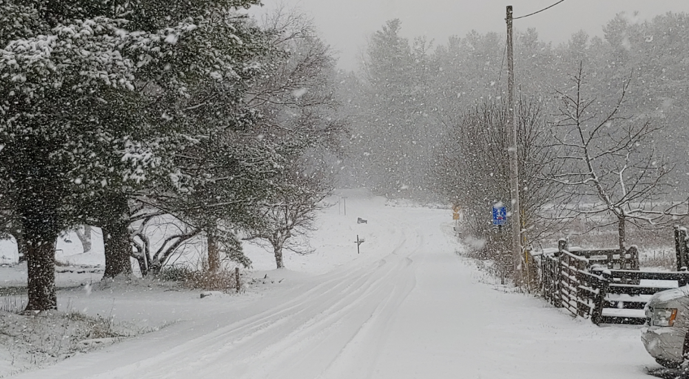
Still far out as most have noted, but the system timing at present is overnight Wednesday. Just one more check mark in favor of accumulations if this pans out. These are some great looking ducks, and they happen to be on a pond.

-
 1
1
-
-
3 hours ago, wncsnow said:
NOAA outlook for the next 3 months is pretty bad.

Meaningless unless you are a trend watcher. I can make 150% of my annual snowfall in 36 hours just like Dec 2018. I dont need, nor want it to be cold for 3 months. I just need a 36 hour window as a friendly LP system happens to stroll on by.....
-
2
-
-
34 minutes ago, BornAgain13 said:
Surprise this morning in Dry Fork

Sent from my SM-N981U using Tapatalk
I was at the farm in Stuart this morning and getting the very light flurries but noticed the radar really filled in nicely with the heavier returns just east towards Martinsville. Glad you got a surprise!
-
 1
1
-
-
Very light flurries up at the farm in Stuart Va and in Kernersville. Maybe a teaser for Magnificent March!
-
Ugh....the silence is deafening. Its either Winter Cancel, or everyone is playing out their deepest superstitions by not talking about it. Either way our winter is two days away from being half over. (I view anything in March as icing on a very rare cake) We're gonna need some serious halftime adjustments because our first half ended by dropping the ball before we crossed the goal line. The fans are restless.
-
3 hours ago, NCSNOW said:
The South of the Border Crusher: Actually just misses to the north. Pedro would have been happy in 9 days. Is that place still open??

I've been watching this board for many years now and I honestly cant recall a storm modeled like that. I'm gonna say that doesnt pan out quite that way.
-
 2
2
-
-
I was happy to see my dusting and got some cool drone footage flying in the snow. But I invested waaayyy to much sleepy time in Katherine. Lesson learned when we dont have a reliable cold source. We easily had the QPF for a 3-5" storm in the Triad. But relying on the boundary layer to win the day for us was just delirium. Wont fall for that again.
-
1
-
1
-
-
1 minute ago, Wow said:
Gigantic flakes coming down
Told ya so .. . .

-
Got the drone up! First time flying in the snow. That was cool. May try to film later once everything is fully coated. If only.......
-
2
-
-
1 minute ago, Wow said:
closer to downtown.. nada
yeah i know it's coming
")
LOL. My daughter lives in Noda and is freaking out. She's like Dad, its circling me but it wont snow here!
-
1
-
-
7 minutes ago, Wow said:
will be rain with snow mixed in.. el busto
You're about to change your tune my friend. Maybe only for 30 minutes, but it's coming.
-
you can watch the pivot happen right around Boonville and East Bend on radar. Precip moves NNW and then stops and starts filling back in moving ESE. Should be a fun afternoon for many.
-
8 minutes ago, SENC said:
Can (I) assume the ULL is making the "transfer" ATM? To the Coast?
We went from Sunny to VERY cloudy Skies, in the past hour..
Cloud deck has Lowered, & looks (Ominous) AND NWS is now calling for a "mix" here on the Coast, Later this afternoon/tonight..
Likely so. I've been watching the radar like a hawk the last hour and sure enough the northerly movement of the precip around the triad has just about stopped. Starting to see some precip heading ESE out of the mountains now. I love my chances at a full afternoon snow at the farm in Stuart now. It's just going to set up camp right over my barn!
EDIT - temp has dropped below freezing now too. Sticking like crazy!
-
1
-
-
Starting to get a little excited that the farm in Stuart might end up near the pivot. Radar looks quite robust back to the WSW and as the day progresses all of that moisture looks to swing thru. I'm quickly headed for a half inch on the security cams, but stay tuned, this could get interesting real quick. For you too @BornAgain13 and @Buddy1987
-
1
-
-
Full dusting now in Stuart Va. Still coming down at a good clip. Maybe squeeze out a half inch or so?
-
Dropping the hammer at the farm in Stuart VA. Will easily give me a dusting there over the next 30 minutes. Big ole flakage.
EDIT - coming down in buckets now, ground going white quick. Too bad I have to watch through my security cams.
-
9 minutes ago, Disc said:
3" and 28F. Dumping snow. Roanoke County.
I expected to be taking this photo here in the Triad. Thanks for giving me that visual @Disc. I needed closure.

-
2
-
-
4 minutes ago, magpiemaniac said:
RAH has reduced my afternoon snow forecast from 1”-3” to just 1”. Tonight is 0.5”.
On to February...
Good luck getting that! I knew we were sunk when I woke up at 3am and the temps were still around 37 and the radar was anemic. I'll take my rate driven dusting this afternoon and join you in February.
-
 1
1
-
-
This is so pathetic I'm not even going to bother sending the drone up. A few flakes in Kernersville but the radar trends say its going to shut down for a couple of hours, at least. The only thing that got my attention was the quick drop in temps over the last couple of hours once the solid returns moved in. Down to 34 pretty quickly.
-
Some sort of graupel like material falling in Kernersville and Walkertown.
-
Light snow in Stuart VA now. More than flurries. 35.5°
-
Spitting just a few flakes in Stuart Va at the farm. Otherwise squat there and squat here in Kvegas. Happy to see a few folks outside the mountains woke up to at least a dusting!
-
Temps being stubborn, radar looks horrible, thinking this may turn out to be a daylight event. Peace out until 6am.
Mid to Long Term Discussion 2021
in Southeastern States
Posted
As I scroll through the last 2-3 pages of posts catching up, many folks here are simply piecing together the best attributes of many disparate model runs and calling it a forecast. There is another common term used here.......wishcasting! From marginal temps to timing to track there are many things insufficient to support a meaningful snow event with this setup. I wouldn't want to be in the "I got my hopes up" camp after this one. 2.4" way down into the sandhills with no cold air source? 6" in south Wake? C'mon son, it's time to kiss da baby.