

kvegas-wx
-
Posts
2,073 -
Joined
-
Last visited
Content Type
Profiles
Blogs
Forums
American Weather
Media Demo
Store
Gallery
Posts posted by kvegas-wx
-
-
Still stars and moon here in Kvegas just east of Winston. Breeze makes it quite a chilly evening. 35 and static electricity dewpoints. I think we got this one in our sights.
-
 2
2
-
-
Many of our mountain brothers are reporting temps 2-4° colder than forecast at elevation, which is roughly between 925 and 850mb I believe. Can we use this intel as a non-model indicator that the CAD is coming in much deeper than forecast? If so, more sleet would be in order on the front end of the event, yes? No?
-
2
-
-
52 minutes ago, norcarolinian said:
38/21 now ... clear skies
Yep, I think we're going low in the Triad. Meaning 29-30° instead of 31.99999°.

Radar looks rather MOIST. GOM firehose engage!
-
1
-
-
We thinking max impacts in the 2-9am range for most of northern NC and southern VA?
-
4 minutes ago, wncsnow said:
Well the latter isn't happening this decade so you should be good too
Worst to first '21. Huge free agency year. Burrow will lead the league in passing yards. You heard it hear first!
-
42 minutes ago, BornAgain13 said:
The Weather Channel App has my area reaching 37 degrees tomorrow afternoon... nothing that I have seen in the guidance shows that...
Are you certain that isnt a midnight high temp? Would make more sense.
-
37 minutes ago, blueheels2 said:
20 years of sobriety lol. I was wanting to get hanmered by the storm but I have no problem with those would partake on a stormy day,.
Good job! I'm such a lightweight I would only partake on a snow day.....or when there is Bluegrass music playing.....or if the Bengals make the playoffs.

-
1
-
-
7 minutes ago, blueheels2 said:
Live in Rolesville. Would really love to get hammered tomorrow and take the day off but probably not going to happen. I’ll gladly take a couple of days without power.
Is there something really preventing you from getting hammered and taking the day off? In the Covid era thats called a mental health day. Do it!
-
1
-
-
The breeze here in the Triad has become steady. My dog is on the back deck looking off to the east and his long fur is just blowing behind him. Not a good sign for ice haters. The dewpoints are gonna drop quick after sunset.
-
10 minutes ago, griteater said:
Latest Model Surface Temperatures at 6AM Thursday at Hickory (HKY) / Greensboro (GSO) / Raleigh-Durham (RDU)
Model: HKY / GSO / RDU
Euro: 33 / 30 / 33
GFS: 32 / 29 / 31
GFS Para: 33 / 29 / 31
CMC: 30 / 28 / 30
ICON: 31 / 29 / 31
HRRR: 32 / 30 / 32
3km NAM: 32 / 30 32
2.5km Canadian RDPS: 30 / 27 / 32
The differences across these models in GSO are the differences between Saturday and 2002. 2° difference between an inconvenience and some lawn cleanup and an icy armageddon.
-
Man this sunshine is awesome. Badly needed for my mental health! If this is what next week looks like I can handle tomorrow.
Cracking the 40° mark here in the Triad and it feels like 50°.

-
Some bright sunshine here in the Triad for a few hours today may help the road situation tonight a bit. But we are nearing the time for OBS with only a few model runs left. Generators were flying off the shelves this morning at Lowes in GSO. They sold 8 while I was standing there.
Lets get this over with. I'm ready for 50's and sunshine next week.
-
2
-
-
8 minutes ago, mstr4j said:
All these low-key posters on the threat threads. I don’t want ice and power outages....but you know they do! SMH.
Nope, nope, nope. Too much time spent prepping before and cleaning up after. Snow is easy, ice sucks. And freezing my ass off grilling outside sucks even worse.
At least this round my genny and transfer switch is in place. Still dont have the whole house package capable of powering heat. But I can get hot water and portable heaters along with the fireplace. Its manageable.
-
1
-
-
I dont think anyone but @wxduncan will care much if the trends go warmer. That being said, these last minute adjustments continue to be a problem that seems to have no solution except finding more data sources other than airplanes.
-
4
-
-
1 minute ago, griteater said:
Look above. The combination of the 850mb low on the MS/AL border and the 850mb high off the SE coast are funneling in warm air aloft. The winds shown here in the 850mb low level jet across east Bama to NW SC (higher than 50 knots) are higher than we normally see in a winter storm. Also, the pre-storm air mass is only marginally cold aloft....so, the strong winds aloft are bringing in the warm air, but it also means that the precip moving in with this jet will likely be moderate to heavy in nature for a few hours.
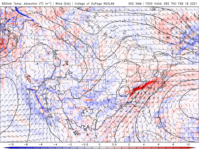
Like it.....warmer rain drops, less accretion. Heavier precip, less accretion. I can see an inch of QPF netting .25 ZR and sparing a lot of folks the severe damage.
-
1
-
-
6 minutes ago, NorthHillsWx said:
1”+ totals, if realized, would destroy the energy grid. That’s enough to down wires without any trees being involved. Generational would be an understatement. Look what <0.50” just did
Totally agree, but I think you would also agree to approach this forecast with some skepticism. Nothing has worked out this year as modeled. Both temps and QPF forecasts have proven to be quite unreliable. If our winter trends hold we will end up with an event like we had over the weekend. If the models bust in the wrong direction this time, then yes, generational will be an understatement. I'm going to be leaning heavily on the HRRR and ICON again on this one. The NAM isn't screaming warm nose as much as it was previously, so I'm crossing my fingers that 75% of what falls in the Triad will be sleet. Time will tell.
-
7
-
-
Seems like there should be some thundersleet in there somewhere? Some very heavy bands setting up.
-
7 minutes ago, Tullioz said:
It may not have been a record, but the ice storm that occurred February 10-11,1994 had some pretty impressive accumulations of ice in NC. It was by far the worst ice storm I ever experienced. In my weather journal I recorded two inches of snow/sleet and 1 1/4" of ice accrual. I was without power for nine days. There were higher amounts of ice reported across the state (Up to 2") and many went without power longer than I did.
Here's a link to a short summary of that event: https://climate.ncsu.edu/climate/winter/event_details?e=132
I lived in ATL that year and was spared the mayhem, but that just seems impossible to get 2" of ice to accrue on anything. The extreme of extremes. The amount of damage that would be done would be unimagineable.
Dont wish for ice storms folks.
-
2
-
-
2 minutes ago, tarheelwx said:
For those of us in the Triad, out of the ICON, RDPS, NAM 12k, and NAM 3k, the one with the least amount of ice is the NAM 3k and it has .45" of freezing rain by 7am Thursday morning. If other models tonight show the same/similar, it might be time to have a game plan for power outages. Saving grace could be sleet, rates so heavy that much of it doesn't accumulate, Miller B with a dry slot, or maybe the temps are modeled a couple of degrees too low.
TW
Or that the precip is too heavy for rapid ice accruals. If it isnt sleet, pray for heavier downpours for most of the event.
-
2
-
-
2 hours ago, SnoJoe said:
I'd take this in a heartbeat. But the way the models are now a days it could be sunny and 60 degrees. Hopefully we'll get some clarity by Wednesday afternoon.

What is this "sunny" thing that you speak of? Please elaborate.
-
 1
1
-
-
1 hour ago, NorthHillsWx said:
Well my buddy in Columbus Ohio doesn’t have the same gripe but is definitely unhappy. They had been forecast to have over a foot of snow but it’s been nothing but a couple inches sleet. I’m sure cliff diving would be similar on here given the buildup and expectation they had. It is falling on a base of 6” of snow and 18 degrees, sigh
Same for my folks in Cincy. The NAM warm nose was right there for all to see on the models a couple days ago. I guess its playing out that way.
-
1 hour ago, PantherJustin said:
I’m bored man, I knew it was reaching. I quit my job with Norfolk Southern (bc it’s sucks and I wouldn’t recommend railroad jobs to anyone wasted 5yrs there) Im a student a stay at home dad currently and literally was that bored
Hang in there. Just don't rely on a bunch of weather binging weenies to provide you with a moral compass and inner strength. This place has devolved into a certified sanitarium.
-
1
-
-
12 minutes ago, PantherJustin said:
Ik this may sound Dumb....
FYP
-
5 minutes ago, CaryWx said:
I don't know that I've ever seen this much overcast at one time over the continental US

Atmospheric terrorism. Gotta be the Russians. Notice how the cloud coverage stops in Central America? Dead give away. We protest.
This would be an awesome animation to see for this week.
-
1
-
February 18-19 MAJOR Ice Storm Threat
in Southeastern States
Posted
Van Denton backing off for the central and southern Triad. Later onset, earlier finish tomorrow. Still more than .25 but the .5 he says will be VA border on up.