

kvegas-wx
-
Posts
2,073 -
Joined
-
Last visited
Content Type
Profiles
Blogs
Forums
American Weather
Media Demo
Store
Gallery
Posts posted by kvegas-wx
-
-
The videos coming out of TX this morning are just sickening. On our best day this winter, or possibly the last 4 winters, we haven't seen snowfall rates like that. Why the hell can't we ever get a blizzard?? Why is my house sinking into the ground? Why do my dogs have mushrooms growing in their paw pads???
THIS SUCKS!!!!!
-
 5
5
-
 4
4
-
-
8 minutes ago, AuerHaus said:
Newbie and intermittent lurker here. NWS Wilmington’s 9 pm (8:53pm) forecast for Cincy has between 9-16 inches of snow.
Can’t post a photo so here’s the text:Detailed forecast forHamilton County
TonightSnow after midnight. Snow accumulation 1 to 2 inches. Lows 15 to 20. North winds around 10 mph. Chance of snow 100 percent.Washingtons BirthdaySnow. Additional snow accumulation of 2 to 4 inches. Cold with highs in the lower 20s. Northeast winds 10 to 15 mph with gusts up to 25 mph. Chance of snow 100 percent.Monday NightSnow. Total snow accumulation of 6 to 10 inches. Lows 10 to 15. North winds 10 to 15 mph with gusts up to 25 mph. Chance of snow 100 percent.Nope, Monday night is stating the TOTAL expected of 6-10" which aligns with the forecast.
-
1
-
-
1 hour ago, PantherJustin said:
Bring it baby!!! Let’s go
You need a solid evaluation and at least two full seasons of therapy.
-
1
-
 1
1
-
4
-
-
13 minutes ago, NCSNOW said:
when you got a tpv parked on the other side of the apps western GL causing snow down to south texas and LA. Then you have a 1040 HP in Maine,almost Banana HP. Storm rides up apps where shallow cold air boundary cant cross over. We get waa over top of stout CAD from HP in NE.
Dude, you may single handedly pull a rabbit out of a hat while nobody is looking. Keep it up.

Now, can you get Dogecoin to the moon?
-
1
-
-
6 minutes ago, NCSNOW said:
Big Ice storm being advertised for Thursday. 1040 HP sitting in Maine
Negative ghostrider. Since when do you ever see ice across that large of a region and on both sides of the apps?? Can we just shut down the models until the planes start flying again? Or maybe start using carrier pigeons with weather sensors, or drones, or kids birthday balloons that get launched from Chuck E Cheeses parking lots. Anything to get better data for pete's sake. This torture must end!!
-
Ice storm a few years back made 220 south (now 74 or 73 I think) headed towards Pinehurst look just like this. Several miles of pines laying on the road before they cleared it all out. I would be hard pressed to sit calmly in my vehicle.
-
1
-
-
13 minutes ago, BooneWX said:
What a painful sight today to see that slug of moisture moving through with temps in the low 30s. Meanwhile, historic snow on the way for Houston and Louisiana.
I’m over winter. I want torch. I want the SE ridge to deliver 80s and historic warmth every single day in March and not a single night below 45 until November of next year. If we can’t get snow, that’s totally fine but enough of it raining 10 inches a week in the 30s.
I'm almost there. I dont mind the cool temps as much as I mind the wet. This is getting ridiculous, and if the summer ends up dry thats even more painful. I was hoping to plant my first full one acre crop this year using my new gravity fed drip irrigation system. (I'm NOT a farmer). This is a fun project for me that mother nature is not making any easier. Cant get the field ready, too wet, and cant get my rain totes in place to catch the rain we have now.
And even worse, the dogs have muddy paws every freaking day!

-
2
-
-
Big difference between power and no power for many could be the fact that winds are nearly calm. The crust is already in place, on everything, here in Kernersville and a quick peek at the security cam in Stuart is a nightmare, but there is no wind. Any change there and yes, lights out everywhere.
Lets hope for a calm rise in temps later today.
-
1
-
-
Just let the dogs out. Deck is crunchy, almost like some sleety material is falling but no idea what it is.
-
1
-
-
Already looking at quarter inch icicles on the Japanese Maple branches. This may not end well in the triad if the heaviest precip is due tomorrow morning.
-
1
-
-
No matter what happens tonight and tomorrow, I can get thru it knowing that my 7 day forecast shows sunny and 50's. Of course the way the models have been verifying, we'll have our Big Dog next Saturday.
Already spitting pretty steady here in Kernersville. I really hope we dont jackpot on this one. 29°.
-
1
-
-
Made it back from Cincy today. Left about 5" of compact snow behind me with another 7-10" coming early next week for a freaking ice storm? This winter in the SE blows. I'm buying grass seed asap. Time for spring.
-
1
-
-
2 hours ago, magpiemaniac said:
The only part of that route that has a current winter storm warning is Beckley, WV. Here’s Beckley’s NWS forecast. I’ve seen worse conditions.

Thanks. This one has me quite nervous because you wont know you are in it until you are in it. Thinking I will slow down a little bit tomorrow and see if I can time my arrival into Princeton, Wytheville and Mt Airy to the late afternoon. I only need 33°. VADOT will do the rest.
I cant believe the cold temps forecasted up here next week wont make it down. Highs of 15°, lows around zero. We just cant win.
-
Help a brotha out folks, I am seriously short on time to really figure this out. As you know I'm rolling back from Cincy tomorrow with your polar vortex in tow. Now I'm worried I'll be making my own ice storm down I77. Is this legit? Should I stay put until Saturday?
-
28 minutes ago, Grayman said:
Nobody knows if summer will be dry or wet. No dogging anybody but we can’t get 24 hours right you weenies
FYP. Yes, model watching has been exhausting this year and we still have little certainty around tomorrow much less a 4 month outlook.
-
5 minutes ago, frazdaddy said:
ok mister that's it , I am officially ignoring you till I get snow or you get back.
I'm so sorry, but its like a damn snow globe up here. Just hammering white powder!!
-
2
-
-
Can I be in my home forum and be whining about too much snow with being banned?

Ripping fatties again here in Cincy. Here comes another 1-3" literally out of nothing. I'm now sitting on 10" since I got here Friday. I just cant believe how difficult it is to get a snow event like this in the southeast.....in the dead of winter.....at night.....it sucks!
-
1
-
 1
1
-
-
20 minutes ago, NorthHillsWx said:
That’s exactly where you’d expect it to be too
The heavier the precip I tend to favor a rain solution when the CAD is marginal. I get that the models often underestimate the CAD, but as shown, I'll favor the warmer forecast. Not to mention I'd rather not drive home from Cincy during an ice storm.

-
2
-
-
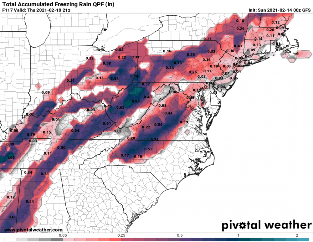
This could end up being a multi-day ice on ice event for some. Very little melting going on. Tenths upon tenths of zr. This long duration event would easily rival the tree damage I experienced back in 2002. Pray for sleet but go ahead and buy your gennie now if you ever wanted one. This is U..G..L..Y!
-
 1
1
-
-
6" of high ratio bliss here in Cincy overnight. We were literally trained by a 75 mile wide streak of snow for 7-8 hours. Simply amazing. Wish I could bring it back!
-
14 minutes ago, Iceagewhereartthou said:
Some interesting run trends today, definitely have to watch the next few days to see what happens. The trend this year has been for the cold to stay West of the apps, and many of the runs continue to show the cold having difficulty making it east of the mtns. Maybe it makes it this time but I would not be surprised to see marginal cold again for most. Looks like we should be paying attention for the next 10 to 15 days though for sure.
Not disagreeing, I'm simply pointing out (while I sit here in Cincy watching it puke snow outside) that starting tomorrow the high temps here wont go ABOVE 25° until the middle to end of next week. This isnt run of the mill transient cold. This has staying power. And we would need a monster SER to block and/or moderate this airmass. I like our chances over the next 10 days.
-
3
-
-
I will say this, I understand how our GSP friends now feel after cashing in the other night. It is ripping fatties here in Cincy, 2-4" tonight. And man is it glorious. But it still isnt the same as having it thump in your own backyard.
-
1 hour ago, tarheelwx said:
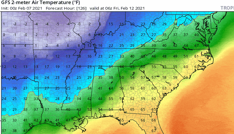
This is anomalous cold air, even for the dead of winter. The models will have a hard time handling such dense cold air. I expect to see the models trend much colder as move through this week. I think the models have trended colder in the 3-5 day range for the last 60 days. The problem until now has been that there's been little cold air to work with. The cold air coming now will be a whole different animal. Tapping regions with dew points in the teens (since back in early December) is totally different than tapping regions with dew points below zero.
I think if nothing else, the dense nature of the cold air will lead to alot of ice, and not just in CAD areas.
TW
Agreed 100%. The Cincinnati forecast has been also trending colder all week this week and the local tv met last night was even talking about the cold press into the south. I suppose it's possible the trajectory takes it into TX/LA instead of the SE, but the cold pool is definitely there. Highs in the teens here by late week, single digit lows. I'll get my fill of snow up here this week as we have it every day in the forecast at present.
-
2
-
-
1 hour ago, NorthHillsWx said:
Just going to leave this here.
That would be me and my F250 hauling the cold back from Cincy on Friday. Highs in the teens, lows below zero here on Friday. I'll do my part for the forum but somebody else needs to figure out the QPF. Still a chance for a Valentine's Day surprise!
-
3
-


Winter 2020-2021 whining thread
in Southeastern States
Posted
For your first post this was a good, yet painfully accurate one. As a fellow 53 year old, I blame millennials (for everything). Somehow they screwed up weather patterns. Welcome to the forum.