

kvegas-wx
-
Posts
2,073 -
Joined
-
Last visited
Content Type
Profiles
Blogs
Forums
American Weather
Media Demo
Store
Gallery
Posts posted by kvegas-wx
-
-
2 minutes ago, BretWx said:

Same model that still shows 7" for the Triad when we will be lucky to get 1". Mountain folks will get theirs for sure. But that warm air is a comin' Sunday afternoon. The ICON isnt accounting for that at all.
-
 1
1
-
-
1 minute ago, wake4est said:
3k NAM


Tree snapper warnings need to be issued. This has officially gone from a sleddable snow to a chainsaw tune-up.
-
2
-
-
1 hour ago, CentralNC said:
As mentioned my several members, you can cut those totals at least in half due to runoff, etc
Yes, at least in half. And if we see significant CAD erosion as ILM ROSS suggested could be possible, it won't even be close to half. You'll see rain washing away all that snow and sleet until it refreezes into Monday morning.
-
1 hour ago, eyewall said:
I just officially checked out of this event. Not sure when there will be another chance if there is at all. The wait is always the hardest part after a brutal blow like this.
LOL!! Once again I think you stole this post from 2020,2019,2018,2017......
Do you have this saved as a favorite or something? I almost feel sorry for you over there in the screw zone. (Almost)

-
Winter Storm (F)Izzy. Can't believe with the change to a colder pattern, finally, that I still need to trek down to NGA and NWSC to possibly see the real deep snow. I will officially transfer to the sanitarium now and hover amongst like minded, emotionally shattered people.
-
 1
1
-
-
7 minutes ago, sarcean said:
This hasn’t really been a RDU storm for days
It won't be a Triad or piedmont storm either! Nothing at all like what we thought would happen, however, this is exactly what we should have thought would happen. (Charlie Brown flies through the air and once again lands on his back)
-
1
-
-
25 minutes ago, olafminesaw said:
GSP is bullish

This will not age well. Are they using models from 2 days ago or what??
-
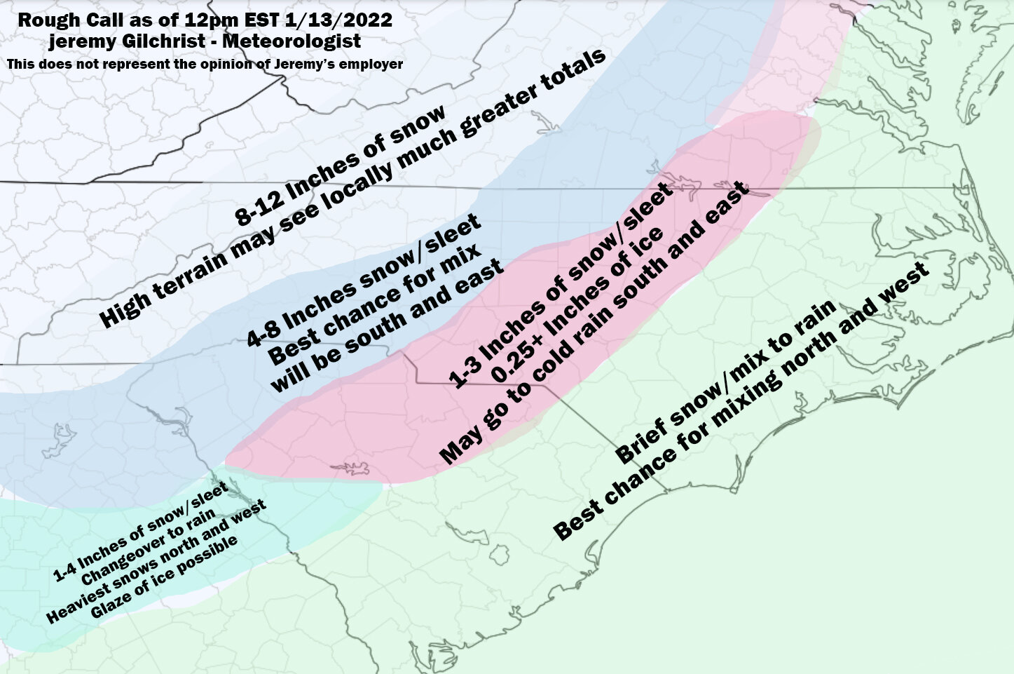
8 minutes ago, eyewall said:
A rough go at a call map for now:
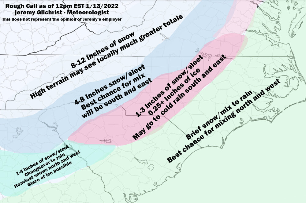
This was almost too easy. A map we have seen dozens of times. Are you sure you just didn't change the dates Jeremy?

Looks legit. I think most here would take those outcomes.
-
3
-
-
1 minute ago, Blue Ridge said:
And likely snow to a lot of ice for Central NC, given surface temps.
It does appear that this system will be a little moist drinking straight from the gulf. And that CAD signal aint no joke. Might be time for that generator after all.
-
1
-
-
3 minutes ago, jburns said:
Damn kvegas, what makes you think you can forecast weather when you can’t even handle time.

LOL, c'mon old man. We're in the same age bracket here. The night ends when we say it ends. And I dont mean when the Viagra runs out. I mean when my old eyes cant read all these dang weather maps anymore!

-
1
-
-
Brace for impact. The next 3 hours will be the most important 3 hours of our winter weather lives.

Well, until tomorrow night at 9pm I suppose.
-
@msuwx Matthew has been awfully quiet on this one but I see him lurking. Any thoughts on the more positive afternoon trends sir?
-
Anyone having that gut feeling that Lucy already pulled the football and we just haven't lined up for the kick yet? Trust your gut. We've all seen this game before and there is no reason not to assume the same outcome here until we are proven wrong. (this will also be my approach with the Bengals playoff game Saturday.....31 years of disappointment.....prove me wrong)
The writing is on the wall folks. When you see that much WAA hammering into the SE portion of the state there's a valid reason it showed up. And if history is a good indicator, that's a trend that usually ends up with 25% of the forecasted snow total across much of CNC immediately followed by an hour of sleet and the rest of the day filled with freezing drizzle. And we haven't even started talking dry slot yet. Prove me wrong.
-
 4
4
-
-
17 minutes ago, SENC said:
I (think) the Modeling (Models), haven't taken this lil tid-bit of Data into account..
(Just My 2 pennies here).. ..
As the Low transfers off the Coast, The SST's here, are in fact, WARMER than usual, than other years.. by 10F .. Temps are still reading 62~65F here on the Beach's..
Yep, depending upon the final track your lil tidbit could end up being the nail in the coffin for most everyone outside WNC and a nasty ice storm for plenty of us. Pass!
-
1
-
-
1 minute ago, WinstonSalemArlington said:
How are you still pessimistic after last week’s wonderful little snowstorm?
Easy. That was a nice little surprise event, 48 hours out, where we always seem to do well with surprise events. Everyone gets a couple inches and we move on. These Big Dogs pan out once every 20 Burger Booms (no offense to Burger of course). The amount of atmospheric alignment it takes to get everyone across the region even a 4" snow is nearly unachievable it seems. We are playing 8D chess with weather models ( are there 8 dimensions in weather?
when all we really want is a good dose of cold and a few hours of rain. So yeah, I'm a little pessimistic on the Big Dogs.
-
1
-
-
1 minute ago, eyewall said:
Current status:
Boone: We're goodCharlotte: This could be the one!
Winston-Salem: Feeling good
Greensboro: Feeling pretty good
Raleigh-Durham: Tanking Maalox and downing Tums
Fayetteville: Day drinking
Wilmington: Hitting the ABC store to re-stock
LOL - wait until tomorrow and the Winston folks will be like "I'll take my hour of snow followed by a rapid change to IP". Guess I can put the sled back now. I feel like the jinx is already underway.
-
1
-
 2
2
-
-
3 minutes ago, Blue_Ridge_Escarpment said:
Have a seat and close the blinds before you look at the ICON snow output.
That's disgusting. (slides the model run back between the mattresses)
Time to haul out the sleds and jinx the whole dang thing.
-
2
-
2
-
-
2 minutes ago, eyewall said:
The 6z GFS retrogrades the low back inland in NC. That is definitely not what we want on that run.
Here comes the slush and cutting snow totals by 80%. I'll give it until midnight before everyone south of Lexington is screaming about the warm nose.
-
1
-
3
-
-
1 hour ago, olafminesaw said:
Right where we want it

I mean it would certainly be a win to see that low a little deeper, maybe Cat 4-5 ish, to make up for that crappy (actually awesome, wink wink) December we just had. I'll take my 23" of powder for my birthday as it stands now, but 40" is better!
-
2
-
-
1 hour ago, Met1985 said:
Looks like the GFS bit the dust with this one.
No kidding. I had already downgraded my expectations in Stuart from "up to 1 inch" to just some light snow, but the radar has just fizzled completely. I expect my WWA will also go "poof" here shortly.
-
WWA out for Patrick Cty tonight for up to 4" but as always, this county is impossible to forecast. Nearly nothing will fall here south of Stuart tonight and the elevated part of the county NW of Primland and Meadows of Dan will probably see 2-4". I'm sure there are several counties up and down the apps like this, Wilkes also comes to mind, where it is nearly impossible to issue a blanket forecast due to terrain variability.
Anyway, still rocking a balmy 50 degrees here in the foothills. Not feeling this one at all.
-
2
-
-
Still dumping snow in Stuart VA. Very unexpected win with the accums. Approaching a half inch in grassy areas.
-
2
-
-
Hammering here is Stuart VA. 20 mins in and everything is covered. Simply amazing.
Aside from having the sun move a few million miles closer to earth, I will never question ground temps vs rates again, ever.
-
7
-
-
15 minutes in Stuart, everything is covered. Way, way, way overperformed anything I thought I would see today. Impressive!
-
2
-


Southern Sanitarium
in Southeastern States
Posted
Are we to nowcasting yet? Waiting on all this nothingness is soooooo boring.