KoalaBeer
-
Posts
623 -
Joined
-
Last visited
Content Type
Profiles
Blogs
Forums
American Weather
Media Demo
Store
Gallery
Everything posted by KoalaBeer
-

A little pre-season thread: Can Nov. 8 pull off an early win?
KoalaBeer replied to moneypitmike's topic in New England
Nothing like having a second meltdown over someone else telling you already had one. Just to funny. I'll be happy if I see any flakes this week and will wait to see if we can cash in early next week. Would rather see the slopes get the goods this time of year anyways even if that means rain for SNE. -
TOR warning for Philadelphia. Overall though surface obs across the mid Atlantic aren't to impressive. Lot of gusts in the 40s.
-
This thread is pretty funny. You'd think think this is the biggest wind event of this century skimming through the posts. I'm expecting 45-50 gust here and short lived. We will survive.
-
Quite the sever outbreak across OK AND TX ongoing...that Dallas cell Mesoscale Discussion 2091 NWS Storm Prediction Center Norman OK 0908 PM CDT Sun Oct 20 2019 Areas affected...North Dallas Metropolitan Area Concerning...Tornado Watch 676... Valid 210208Z - 210245Z The severe weather threat for Tornado Watch 676 continues. SUMMARY...Tornado is currently ongoing across northern Dallas County. The environment is supportive of a strong tornado, with additional tornadoes possible downstream in the next hour or so. DISCUSSION...Recent radar signatures from KFWS reveal an intense supercell characterized by a 0.5 degree rotational velocity between 60 and 65 kt. A tornadic debris signature has also been noted on recent radar scans. This signature is occurring in an environment characterized by STP between 3 and 4. Previous signatures within similar environments produced damage-estimated wind speeds from 120 to 160 mph and a confidence is high for an intense tornado. ..Squitieri/Grams.. 10/21/2019
-
Power out here in west Methuen.
-
Rocking here in North Andover. Was surprised to see a few power flashes though, I guess the wet ground and foliated trees aren’t helping. Impressive storm on sat images. Down to 988mb here.
-
https://vortex.plymouth.edu/cgi-bin/rad/gen-ltdwr.cgi?pl=dhr&cu=1&loop=no&ident=BOS
-
Probability of Watch Issuance...5 percent SUMMARY...A marginal wind damage/tornado threat may develop across parts of southern New England this evening. The threat should remain below levels needed for watch issuance. DISCUSSION...Water vapor imagery shows an upper-level low over the lower Great Lakes region. A plume of mid-level moisture is located across northern New York and New England with a dry slot moving northeastward into the Northeast. Ahead of the dry slot, a broad area of rainfall is located from eastern New York into southern New England. At the surface, a rapidly deepening low is located just south of New York City. The RAP is analyzing a corridor of instability from near New Jersey extending well offshore. Thunderstorms are developing on the northern edge of this instability to the south of Long Island. This convection is forecast to move north-northeastward across southern New England over the next few hours. The WSR-88D VWP show a strong shear profile with 0-6 km shear near 60 kt and 0-1 km shear near 40 kt. In spite of the weak instability, the shear environment suggests that the stronger cells at the back edge of the rain shield may be able to rotate. These cells may become strong enough for a marginal wind damage and isolated tornado threat as they move across far southern New England this evening.
-
To be fair a 975mb low doesn’t cut inland across the state often in winter either. Lack of mixing is inhibiting this from being a more significant event.
-
Highest I see on mesowest is 43 at Atlantic City. Looking good on the IR floater now. https://mesowest.utah.edu/cgi-bin/droman/meso_base_dyn.cgi?stn=KACY&unit=0&timetype=LOCAL edit: down to 992mb there as well. Starting to bomb.
-
John Oliver on Weather forecasting
KoalaBeer replied to Jim Marusak's topic in Weather Forecasting and Discussion
I enjoyed the segment and thought it was pretty funny. I never got why the general public relies on Accuweather so much and I've always have tried to steer my family and friends straight to the source (NWS). Joe Bastardi used to work for them right? Would have been funny if he incorporated that into the segment as well.
-
FWIW BOX is going with 35-50 kt gusts on the coastal plain right now. I don't think that's an unreasonable forecast. These never seem to work out here in NW Essex county however. I'll pretty much always take the under on these events for wind in these parts. October 29-30 2017 was an exception here though, LWM gusted to 51mph before it stopped reporting. I would guess we had a few 65/70 gusts that night. Surprisingly that event doesn't get talked abut much as it was an interesting setup. Those big pines were snapping all over that night.
-
Was hoping the same thing to play some golf later but looking at GOES-East not sure it will happen. Winds still coming form the N/NE in pushing that moisture in off the ocean. Could be worse...parts of ND just got a foot of snow. Some reporter on the weather channel was just walking around in a deep snow drift and called it a "snow dune" because it reminded him of sand dunes.
-
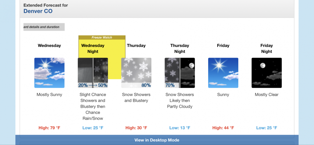
It definitely was an experience! I remember thinking New Englanders were full of crap with "If you don't like the weather, wait 5 minutes" you hear all the time haha. I'll admit though, I like the variability of our climate more overall. Nothing beats a bombed out nor'easter deformation band sitting over your head. Looks like DIA went from 82F to 19F in 18 hours for a temp change of 63 degrees. That is sick.
-
I love New Englands variable climate, but these are the days I miss living in Denver.
-
I was up by Tenney today on the way home from the Whites and it reminded me I need to check it out this year as well! If I recall correctly there is no snowmaking since they re-opened? All natural which is pretty sweet.
-
Ragged Mt is not nearly as big as places like Cannon or BW but still offers some great terrain. There trees are actually awesome and they get sneaky dumped on a lot. There season pass is only $349. I typically grab one even if I have another pass elsewhere. Not a bad drive from Lowell either, probably an hour forty-five minutes and it's pretty nice that your not on the highway the whole time IMO.
-
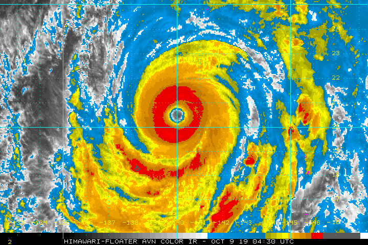
OT but anyone see the Typhoon in the WPAC? Looks like Patricia/Wilma intensity. Definitely fits the bill for one of the most intense TC observed.
-
Nice temperature inversion going on out there. 37 up on Mt. Washington but 28 where I’m staying in Jefferson NH for the weekend.
-
Let it begin! Looks like A-Basin out in CO has turned the snow guns on and Killington was testing there guns yesterday. Looks cold enough to turn them on tomorrow night but doubt they do with the way the rest of the week looks.
-
65mph...Don't see that often.
-
CF coming through here now. 66 KLWM with 73 at KBED. Might have to go squeeze in 9 hole after work when the rain clears out. I love playing some fall golf.
-
Wouldn’t be surprised if it briefly retains major status before weakening commences.
-
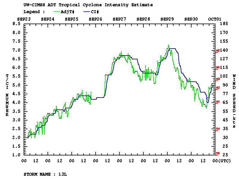
Dang Lorenzo just cleared out an eye. Wasn't expecting that.