

CheeselandSkies
-
Posts
3,250 -
Joined
-
Last visited
Content Type
Profiles
Blogs
Forums
American Weather
Media Demo
Store
Gallery
Posts posted by CheeselandSkies
-
-
34 minutes ago, Stebo said:
I wouldn't go down to 200 per day, but could we get down to 1000 by say May? I think so. Maybe even 500 or less during the summer. If the vaccine can be distributed much quicker then less.
Great, down to a 4/27/11's worth (give or take a hundred) of deaths per day and that'll be great progress.
This whole thing has really made weather seem a lot less awe-inspiring (that combined with the extended period of atmospheric suckitude in the central CONUS).-
 1
1
-
-
You know it's bad when Angry posts something that makes sense.
-
1
-
 1
1
-
-
5 hours ago, andyhb said:
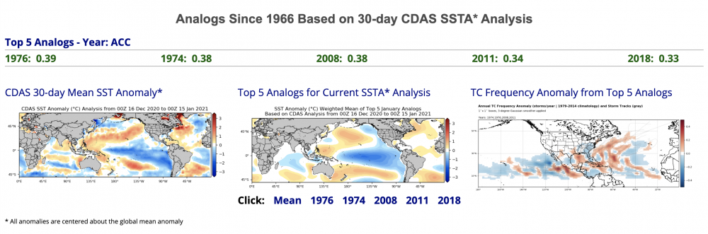
Looks like Tropical Tidbits has their SSTA analogs up and running again. That would certainly be a favorable set for an active severe weather season, especially early season.
On the other hand, rapidly decaying Ninas in 3.4 over the past 20 years have been very unfriendly to the Plains in peak season, as such years consist of 2006, 2009, 2012, 2017, and 2018.
About as stark a contrast as you can get between those two sets of analogs. I sure as hell don't know what to make of it. Granted ENSO isn't the only large-scale driver of severe weather potential but it'd be much more confidence-inspiring to see things leaning more 1974/2008/2011-ish than 2006/09/12/18, although the line seems rather fine. Also, at least anecdotally, 2012 behaved nothing like the other years in that group being extremely warm and dry throughout the central CONUS from March through about September.
Also, shouldn't this be "2021 ENSO" by now? Seeing as we skipped over 2020.
-
13 minutes ago, hlcater said:
the 2nd dose blows. That's all im gonna say.
Which one did you get?
-
2 hours ago, CheeselandSkies said:
Wasn't it supposed to be snowing by now?

Finally coming down here, pavement and parked cars lightly coated.
-
Wasn't it supposed to be snowing by now?
-
6 hours ago, Hoosier said:
Northern tier well on track for a warmer than average January. I don't think +15 is getting eradicated.

Still cold enough to make my knuckles bleed...and not a one day warm enough for this:
-
I'mma need it to not snow on Thursday, k? I've got Wed-Friday off this week and I had planned some travel, but as a rule I don't drive when snow is falling unless absolutely necessary.
-
 1
1
-
-
Very interesting article from New York magazine. I've been dead-set opposed to any suggestion that SARS-CoV-2 emerged from anything other than a natural spillover event, because the insinuation that it was lab-created in China whether intentionally as a bioweapon, or by accident has almost from the beginning been used as a blame-shifting excuse by the ***** admin and its MAGAhead sycophants.
However, this article goes into great depth about the risks of so-called "Gain-of-function" research and makes a plausible case that an accidental release at the Wuhan Institute of Virology could have been the final link in a chain that began with a bat coronavirus that infected its first humans (through massive overexposure, and couldn't transmit between humans at the time) all the way back in 2012, in southern China hundreds of miles from Wuhan. I'm not saying it's convinced me, but it's certainly opened my mind a little more to the possibility.Make sure you have ample time and some popcorn, it's a lengthy read.
https://nymag.com/intelligencer/article/coronavirus-lab-escape-theory.html
-
2
-
-
I have at times found myself driving in snow when none was in the forecast, pulled up my radar app and gone "WTF?! There's nothing here."
-
1
-
-
The equivalent (or more) of a 9/11 or about 2 Titanic's worth of deaths in this country every day from this one cause (or in weather terms, about 1 1/2 Hurricane Katrinas or 8-9 4/27/11s) but they're mostly elderly and probably would have died within 10 years anyway so sure, no big deal.

-
1
-
-
3 hours ago, Hoosier said:
Really depends on what individual preferences are. If we manage 1 huge storm, that will make it a good winter in the eyes of some.
I'm definitely in the "go big or go home" camp. I like stuff that's meteorologically impressive/unusual. Sustained cold/built-up snowpack doesn't do anything for me since I'm not into snowmobiling and the like.
-
After a brief intermission due to the sun-induced melt yesterday, the Great Midwest Rime Ice (Not Hoarfrost) Party of 2021 has resumed. Today might actually have been the most spectacular day yet.


Sent from my Pixel 4a using Tapatalk
-
6
-
-
24 minutes ago, madwx said:
Freezing fog came in overnight and deposited rime ice on everything. Looks as if it had snowed overnight
Yep, back to the same old grind. We could see about a week straight of this.
-
I'll jump on the hoarfrost train. Got more with my DSLR.


Sent from my Pixel 4a using Tapatalk-
6
-
-
Another epic fail of a chase "season." Sequences like May 4-10, 2003, May 21-30, 2004 and May 22-June 12, 2008 (2010 wasn't bad either, between 5/10, Bowdle and the June events) seem to be a thing of the past. 2019 tried but each day had issues that led to them coming in below their ceiling, with unfavorable storm modes and the like (plus the abominable wildfire haze).
I'm finding it harder and harder to go into spring with the same anticipation that I used to because my expectations keep getting crushed. Kind of like how @beavis1729 feels about winter.
-
2
-
-
On 1/4/2021 at 12:04 AM, StormfanaticInd said:
 This is a heck of a set up. Given what happened in the Bearing sea a couple days ago there could be a big system between the 16th and the 21st if my calculations are correct
Great, just in time for my birthday (not that I have any plans or am going anywhere this year)...
-
Car facing me was clean when it was parked there. Two forward-parked cars to the left have not been cleaned off since Tuesday night's snowfall.

Sent from my Pixel 4a using Tapatalk-
4
-
-
Light snow has commenced in Madison. Band of >30dbz returns is just southeast of us. @madwx @Luftfeuchtigkeit @Geoboy645
-
Dry in Madison so far. Looks like we're riding the cutoff between about 1" and zilch.
I haven't been following this event too closely since it became clear it wouldn't be too sig for us, but this thread has taught me a lot about why significant ice storms always seem to either happen without warning or when one is forecast, it busts. There's a really narrow window of ideal temperature profiles and precip rates for efficient accretion of freezing rain.
There was one morning back in I believe the winter of 2013-'14 (one of our first winter precip events of the season, before it became legendary) where I woke up to, completely unexpectedly, find my car encased in about 1/2" of solid ice. -
Back side of the snow seems to be clearing Madison now, heavier rates definitely missed us to the west/south. Doubt we made warning criteria totals here and points north.
-
9" and "still snowing heavily" at Lowden, IA per co-op observer.
-
1
-
-
Me looking at MKX radar and seeing the reflectivity drop off sharply in eastern Iowa:
"I wonder if there's anything back to the west..."(Pulls up DVN radar)
"Holy **** is that a supercell?!" (I know it's not, but you don't generally expect to see >55dbz returns with a winter wx event)
-
2
-
-
8 minutes ago, madwx said:
and it's started at my place. flurries now but should ramp up quickly
Same. Looks to be picking up already.


2019 ENSO
in Weather Forecasting and Discussion
Posted
2014 wasn't bad considering the slow start (although frustrating for me since I missed the Pilger family by an hour and targeted Iowa the following day, but at least the opportunity was there). There were a number of high risks in 2001 but they generally busted.
2017 was meh, but actually one of the better post-2015 seasons, sadly. The event of the year locally happened before I was ready for it (February 28th).