

CheeselandSkies
-
Posts
2,961 -
Joined
-
Last visited
Content Type
Profiles
Blogs
Forums
American Weather
Media Demo
Store
Gallery
Posts posted by CheeselandSkies
-
-
Over 700 wind reports over the two days. Impressive serial derecho.
-
 1
1
-
-
@madwx @DanLarsen34 When was the last WSW event for us that actually verified with totals meeting the criteria?
-
18 hours ago, mempho said:
Since 1950 the State of TN has only had 6 EF 3+ tornadoes and 2 EF4+ tornadoes.
This- while not impossible - double digit snowfalls would be a more common occurrence.
That doesn't mean that we won't see such an event but I wouldn't bet the house on it either.
Sent from my SM-G950U using Tapatalk
That can't be right. There were at least that many F4+ in the state on April 16, 1998 alone, plus several E/F3+ on days like Veteran's Day 2002, May 4, 2003, Super Tuesday 2008, and April 27, 2011.
-
2 hours ago, SchaumburgStormer said:
The backside better be rocking or everyone is going to embarrassingly bust.
(Poor WI crew, from a 20” big dog to advisory levels in a couple models runs hours before onset)
WSW downgraded to WWA for Dane. This system has confirmed for me that models are pointless. I quit.
-
1
-
 1
1
-
-
4 minutes ago, janetjanet998 said:
Yes but storm mode is still "grungy" as it has been most of the day
once it starts that way it's hard to snap out of it..many outbreaks I have followed underachieved because of it
80kt kt LLJ later may have a surprise or two
That's about what I expected for today based on some of the issues I saw in forecast soundings. Storms have been intermittently severe with a few confirmed tornadoes, none particularly long-lasting or violent-potential-appearing (in contrast, to, say the 62-mile track beast of December 16th).
Not that warnings shouldn't be taken seriously, especially at night.
-
TDS with the western AR cell. I'd post a radar image but my attachment limit is capped at 0.16 MB.
-
That is one gnarly tornado-warned LEWP. With it being so close to the radar, hard to tell if the CC is showing a TDS or just noise.
-
@DanLarsen34, what are you seeing?
-
5 minutes ago, madwx said:
Starting off as sleet here with a couple snowflakes mixed in.
Pingers, pingers, we've got pingers.
-
1
-
-
1 minute ago, Chinook said:
New tornado warning says that this is a radar confirmed tornado.
TDS is just NW of Keys, OK.

-
Crowder, OK cell has my attention at the moment, moreso than the Muskogee one. Rotation looks tighter on that one.
-
1630 out early, little change.
-
1 hour ago, weatherwiz said:
12z sounding out of DFW...yikes

Yeah, that is a lot less 850-500mb veer-back than was shown in most NAM forecast soundings 24-36 hours ago. Much more favorable wind profile in the low to mid levels.
-
Just your average 65-70 degree range of possibilities.
-
3 hours ago, Drz1111 said:
This strikes me as a warm-season plains chaser mindset, when this is a cool season Gulf Coast / Dixie Alley setup. "Widely visible tornadoes" isn't really relevant when storms are moving at warp speed and LCLs are scraping the ground.
Yeah...it kind of is. That's one of the reasons I geek out about severe weather setups (that I can't chase myself), the possibility of armchair chasing and seeing live streams of video like this.
Not to say that it won't be dangerous or capable of producing significant severe weather, just that the likelihood of tornadoes capable of leveling a frame house is not particularly high with this event (not that there couldn't still be a few).
Either way this has been and continues to be a fun system to track, both the severe aspect and the potential winter wx aspects for MBY this coming weekend. -
1 hour ago, Bob's Burgers said:
I looked it up and the Moderate was a Day 1 0600 UTC upgrade. Here is the outlook created on 1730 UTC Jan 21
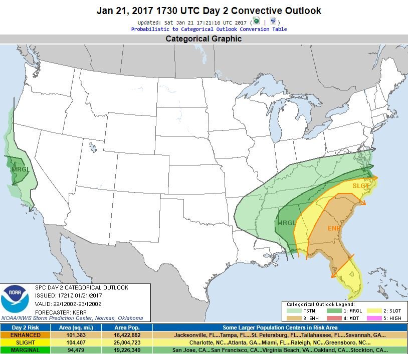
Wow. One of very few high risks (perhaps the only one in the 21st century) to not be preceded by a Day 2 Moderate.
-
1
-
-
14 minutes ago, Bob's Burgers said:
Day 2 Severe Weather Outlook is only the fourth (4) time SPC has issued a Day 2 Moderate Risk in January, & first since 2013.
From Patrick Marsh ^
Wouldn't they have done it for the January day in 2017 that became a high risk on Day 1?
-
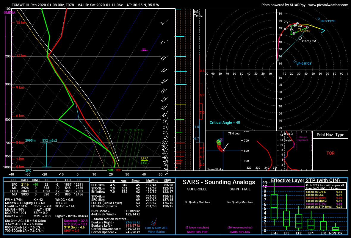
Major veer-backing above 850mb in a lot of those soundings. Wind profiles get somewhat more favorable Saturday over MS/AL compared to Friday over TX/LA, but this wind profile is probably about the best I've found and even it is fairly unidirectional. I would look for a QLCS capable of widespread damaging winds and a few embedded tornadoes, some possibly strong. However, I'm not sold on the potential for sustained free warm sector supercells capable of long-track, EF3+, widely visible tornadoes. Not to say this couldn't still overachieve in that regard a la 12/16.

-
15 minutes ago, Bob's Burgers said:
The euro is the new hype machine lol
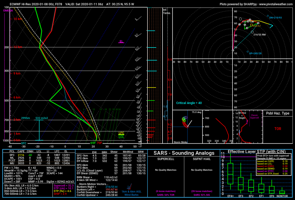
Still quite a bit of VBV in this sounding. Shear profiles are progged to improve somewhat through the day Saturday in southern parts of MS/AL and the Florida panhandle. I think that's where/when any long-track, EF3+ supercell tornadoes will be with this event if things stand as they are.
-
1
-
-
Friday afternoon over E. Texas, EHI ticked up again on the 12Z NAM but VBV is quite pronounced above 850mb in forecast soundings from the most unstable areas. That's not a look for sustained open warm sector tornadic supercells. There could be some pretty potent QLCS tornadoes though with the amount of turning below 850mb.

-
2 hours ago, LansingWeather said:
Man I'm sick of the heat, I want the freezing rain or snow!
I'd be sick of the quakes, too!
-
43 minutes ago, madwx said:
congrats MSN. Euro really deepens the main low this run

-
2
-
-
The lapse rates on the GFS for Friday afternoon/evening in the Arklatex/lower MS Valley made me sit up and take notice. Those are often the make-or-breaker in low-CAPE cool season setups.
-
19 minutes ago, A-L-E-K said:
i'll take a persistent western monster trough and open gulf and roll the dice with the rainers
In A/M/J, please. Not this crap in Dec/Jan then snow at the end of April again.
-
2
-


January 10th-12th Winter Storm Potential
in Lakes/Ohio Valley
Posted
Possibly, but it seems all the expected big dogs last winter (including the one at the end of April, lol) verified on the low end of expected totals.