

CheeselandSkies
-
Posts
2,961 -
Joined
-
Last visited
Content Type
Profiles
Blogs
Forums
American Weather
Media Demo
Store
Gallery
Posts posted by CheeselandSkies
-
-
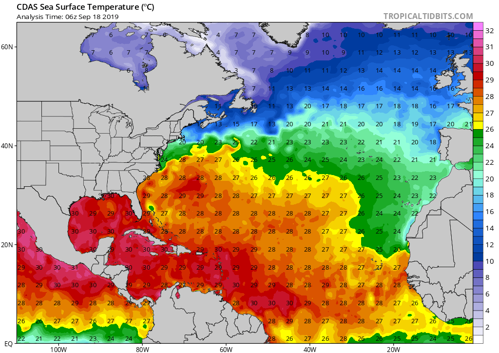
6 minutes ago, Hurricane Agnes said:
As an interesting note, the SSTs are still toasty even after the passage of both Dorian and Humberto (although I know this is slowly ramping down from the peak period for ocean temps)!

That little green hole near/north of the Abacos and Grand Bahama...
Still, presumably quite a bit smaller than it was 10 days ago.
-
Monday night/Tuesday morning I was driving in to work (3:00 AM start, lived in an apartment a block away from my work until the end of August but am staying with my gf at her current place across town until our new lease starts on the 14th) in a torrential downpour most of the way. Saw the lights of a utility truck in the distance as I turned onto the street. As I got closer I saw that it was half blocking our employee driveway. A big tree had come down taking out some power lines. We were on generator power and my old apartment building was blacked out.
More storms this morning, sun's out now with a blue box in effect for an expected later round. So far September feels stormier than May and June in this neck of the woods!
-
SPC says "meh" with just a marginal risk in place for Day 2. Keeping an eye on Wednesday locally but would like to see the front slow down a tad so it doesn't end up a LP of Michigan event.
Sent from my SM-G955U using Tapatalk -
7 hours ago, Stebo said:
100% will verify, it sidesteps Michigan perfectly.
...and Wisconsin.
-
5 hours ago, Hoosier said:
(for example, 2012 was a -NAO summer).
As they say in Ireland..."Whale oil beef hooked!"
-
 1
1
-
-
17 hours ago, wisconsinwx said:
Anyone else think 2003 is a good analog so far for this warm season? That seems to be the epitome of a slow start to summer around here among the last 20 years anyways.
That year we actually had some decent tornado events (not including Iowa troll days) in this part of the country by the end of May. Particularly the 10th and 30th.
-
Has it dying out and missing me to the west.
-
32 minutes ago, USCAPEWEATHERAF said:
Moderate Risk for severe storms today across the central Plains, from NE to IA southwestward to OK and TX, enhanced risk around that area and than in the Northeast US/OH Valley. The Dayton, OH area tornadoes last night destroyed a large area of real estate, I would not be surprised to see the NWS damage surveys conducted the next few days determine that some areas were hit by EF-5 winds.
It's early, but I have yet to see anything strongly suggesting EF4 damage, let alone EF5.
-
1 hour ago, StormChaser4Life said:
Warm front surged too fast across IL prior to storm initiation. Surface winds veered terribly and killed low level shear. Storm mode was great further south but just couldn't tighten up with lack of low level shear. Needed that warm front. Had a nice LP supercell in Peoria county with rotating wall cloud. Came close to producing
That figures, on a day when I and most others were expecting the typical problem of the WF getting hung up to the south to be the fly in the ointment (if there was one).
-
1
-
-
Some (myself included) are finding the dense clustery convection (even with strong UH streaks) apparent on the HRRR and 3KM NAM concerning for chaseable tornado potential. I'll re-post what I just posted on ST Discord:
I admit I often fail to do this enough, so let's go through some of the factors that usually lead to the convective mess/quick upscale growth the CAMs are hinting at.
Low-mid level VBV? Not really seeing it.
Shear vectors parallel to the initiating boundary? Not that I'm seeing.
Too much forcing for too little capping? Possibly.
Any others I'm missing?
Although regarding the forcing, isn't that usually a problem with a very strong synoptic system? Per mesoanalysis, this SFC low should be deepening with time (a positive if you want storms), but not getting TOO deep (~1000MB), which might actually lead to a higher significant tornado threat.
-
It's still early and this line is weakening and flying NNE. Should be plenty of time for the WF to move north with destabilization in its wake, provided nothing else blows up for a while.
-
1
-
-
Ugggggh, if it was two hours earlier I'd be out chasing these things.
-
5 hours ago, DanLarsen34 said:
Man the Oklahoma tornado looked violent yesterday.
Laverne getting a 1991 redux while the TX PH was getting an Allison/Kellerville redux. Those violent wedges tracking through the dusk and murk are scary...that's what most of us thought was gonna happen in spades last Monday. I was 2-3 miles from the eventual Mangum storm as it crossed US 62 near Gould and couldn't make out any definition of the updraft or what was going on under the base. It seemed those who got the tornado were those who got much closer and/or core punched, something I wanted no part of expecting tornadoes of the type above to get on the ground and stay on the ground, with Godzilla hail in the cores.
-
1
-
-
15 hours ago, cyclone77 said:
Strange goings on here. Getting 50-60mph easterly winds on the back side of these rain showers lol. High wind warning out.
I was driving through that on my way back from my lovely (sarcasm) Oklahoma chase on Monday. Did wonders for my fuel economy I'm sure and almost pushed me off the road several times. Couldn't stay out there for today and tomorrow due to having to be back at work starting 3 AM tomorrow morning.
-
Which it did...and largely busted as we know.
If Monday holds serve from the 00Z suite, I suspect it will break the streak.
Sent from my SM-G955U using Tapatalk
-
6 hours ago, Witness Protection Program said:
I'll give him props if he goes out like a cow in Twister.
That would be funny if it hadn't actually already happened. RIP TS/PS/CY.
The weird and especially sad thing is, for those guys that wasn't their chasing style at all. -
12 hours ago, cheese007 said:
Tomorrow marks two years since the last high-risk day. Wonder if we'll break the streak in the next couple weeks or go for a record-long streak in 20?
If Monday holds serve from the 00Z suite, I suspect it will break the streak.
-
Hot diggity.
...and yeah, I've never understood exactly what separates a "PDS" warning from a TORE. I would guess proximity to a populated area, but I have seen "PDS" warnings used instead even when the couplet looked to be approaching a town/city.
-
If a 5/3/99-like event occurred every time it popped up as an analog on a forecast sounding, every human settlement in Oklahoma and Kansas would have been leveled several times over by now.
Interesting analog for W. Kansas near Garden City tomorrow evening (5/3/99 - OKC).
Sent from my SM-G955U using Tapatalk
-
 7
7
-
-
4 hours ago, cheese007 said:
D3 enhanced risk with sig hatching including portions of DFW for Saturday
EDIT: Enhanced countour for the 20th including OKC as well
It's almost all for MCS junk.
-
I give up. We don't get significant tornado outbreaks anymore. Mother Nature is just trying to drown us.
-
1
-
-
DDC/Chapman in 2016, maybe? And even those days were kind of subtle in the medium to long range. My eyes were on that Thursday when the main trough was progged to finally eject into the warm sector. However (surprise surprise) it turned into a VBV-plagued convective crapfest.
-
 2
2
-
-
8 hours ago, Hoosier said:
This is brutal if it verifies

I didn't used to mind but this decade particularly the latter half has gotten me to that point. I officially hate living in Wisconsin.
-
2
-
-
39 minutes ago, Hoosier said:
I believe that is playing a big role. Negative NAO was hard to come by during winter but it has been negative more often than not for the past month or so.
Naturally.


Post Tropical Storm Jerry... exiting stage right and about to dissipate
in Tropical Headquarters
Posted
The general consensus I've read seems to be the 500mb pattern will favor recurves east of the CONUS the remainder of this season, but of course never say never when it comes to the weather and October is when things often spin out of the Caribbean and get nasty in the Gulf as we saw with Michael last year and to a lesser extent Nate the year before.
I don't know how much difference it would have made rain-wise for Beaumont, but with the way it spun up, imagine what Imelda could have done with another 24 hours over water.