

CheeselandSkies
-
Posts
3,369 -
Joined
-
Last visited
Content Type
Profiles
Blogs
Forums
American Weather
Media Demo
Store
Gallery
Posts posted by CheeselandSkies
-
-
8 minutes ago, luckyweather said:
Smoke induced convection, new one for me.

Hell I'll gladly take some footage of a smoke
 if it forms within view of my porch. Otherwise I'm getting hammered after work and staying tf inside.
-
 3
3
-
-
Tuesday was 5 years since a fairly prolific tornado outbreak in north central-northeast Iowa. I managed to put myself in great position for the Waverly multivortex EF2 and then blow it, only getting 30 seconds or so of footage AFTER it produced its last visibly condensed vortex. Thus I don't count it as my "official" first tornado although I did glimpse an elephant's trunk vortex in my rear view mirror before pulling over, snapping a photo (during which it was still partially condensed) and then rolling video after which it stubbornly refused to condense again and I was apparently more interested in filming the more visually ominous inflow band.
-
 2
2
-
-
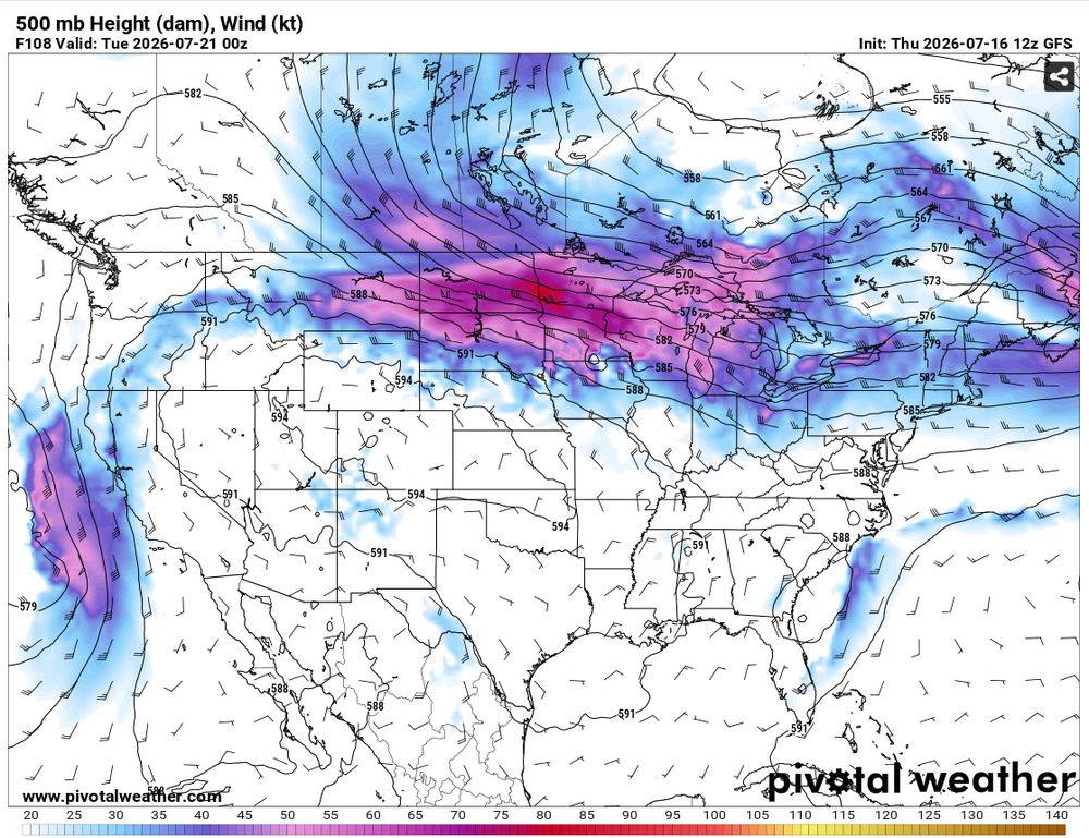
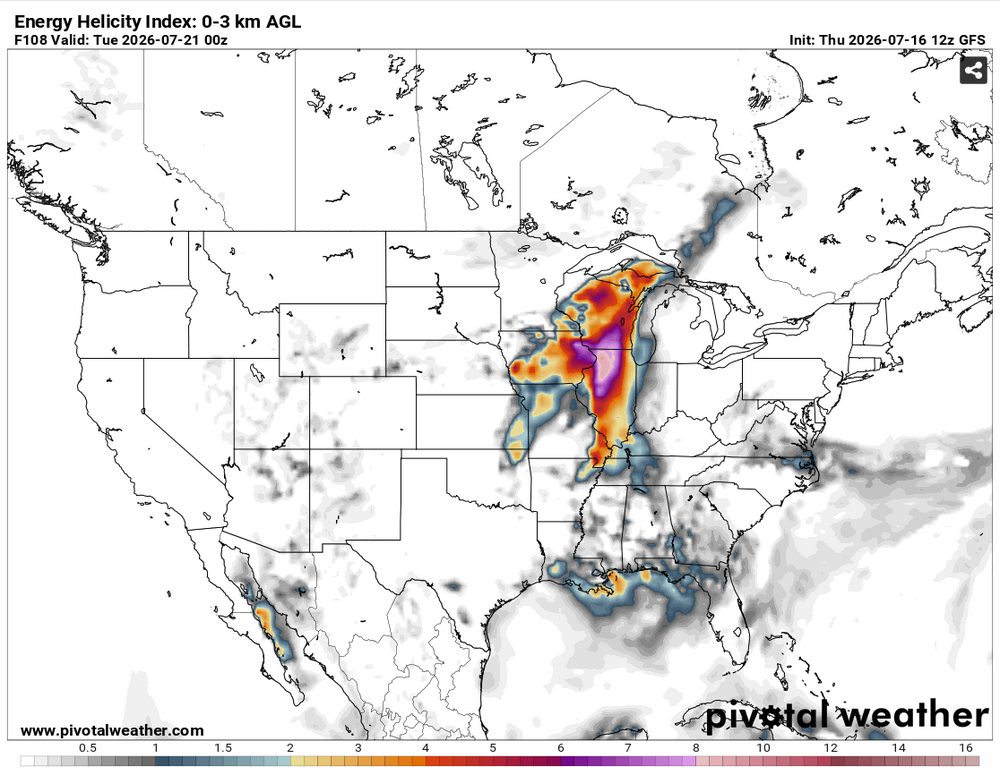
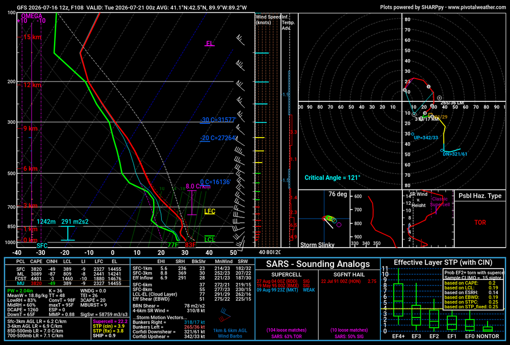
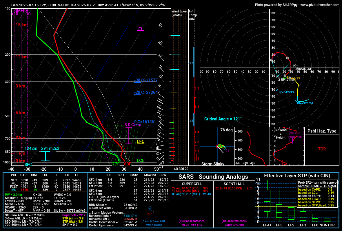
12Z GFS (among other models/ensembles as per SPC's latest 4-8) is spicy for Monday 7/20. However I think a lot is going to depend on if these fires can be tamped down somewhat in the meantime, as this would be another northwest flow setup.
-
1
-
-
Mets at my work said we hit upper 400s for AQI around midday, shattering the old record for Madison (set during Smokeageddon '23). However my phone hasn't budged from the 156 it displayed early this morning, even after I rebooted it.
-
6 hours ago, OrdIowPitMsp said:
AQI is 483 right now in Minneapolis.
Yuck. I think the highest I saw on my phone during Smokeageddon '23 was in the high 300s. 156 right now. Definitely has that hazy look and campfire smell.
-
21 hours ago, A-L-E-K said:
one of the only miss north heatwaves i can remember
As annoying as a miss south major winter storm.
-
 2
2
-
-
23 hours ago, roardog said:
You wanted heat for your garden. Your vegetables will be coming pre-cooked.
Bonus, kill off the Cyclospora parasites.
-
On 6/22/2026 at 10:51 AM, Torchageddon said:
Stupid X posts won't allow me to see the og images so I can't find out what Z is
 .
.
I feel there is a parallel to IL's insane tor numbers, what state had numbers to the moon one year? AL in 2011?
On 6/22/2026 at 12:11 PM, luckyweather said:AL in 2011 with 146. “Padded” with 62 on April 27.
KS in 2008 had 187.
TX in 2015 had 244. Still a few outbreaks away from touching that in IL.Yeah, being the epicenter of a super outbreak will do that.
-
Been shut out of even attempting to chase all the recent IL
action by the setups occurring when I'm on a family vacation (6/11), on Father's Day (yesterday), or simply too far south for a workday/night chase (the one in between). However, this is what I was doing 10 years ago OTD:
-
4
-
-
41 minutes ago, Chicago Storm said:
the 2026 illinois tornado total was at 134 prior to yesterday. combine yesterday with last thursday’s info still incomplete, and we’re probably right at the record currently....and nearly all of them have been south of I-80/definitely 88. The exception on 4/17 I didn't chase...assumed everything would be HP and it was...except when Harrison-Rockton briefly popped out of the rain and was gorgeous.
My only tornado this year is in Minnesota of all places, on April 13. Sandwiched between driving back from my tour which ended in OKC on the evening of 4/12 and nearly wrecking my car chasing 20 miles from home on 4/14.
-
All that, and I slept right through the storm.
-
4
-
-
1 minute ago, Eskimo Joe said:
Wasn't there someone in this thread earlier that was lamenting Wisconsin getting shafted again?
That would be me.
-
2
-
-
5 minutes ago, Malacka11 said:
The low-level clouds turboing by is just absolutely crazy
Sign of very strong LL shear. I've seen it when arriving to the target area on nearly every chase day I've had when I've either seen tornadoes, or there were tornadoes in the vicinity but I missed them due to being dumb. Shame it will likely go to waste for anyone north of I-72 today.
-
1
-
-
Chase plans cancelled due to clear southward shifts in supercell tornado risk coupled with a brutal week at work.
Tornadoes miss southern Wisconsin/IL north of 88 to the north in April and to the south in June? Go figure.-
 1
1
-
-
4 hours ago, SchaumburgStormer said:
Fucking Broyles
I got a DM from someone purporting to be Chris Broyles over on Talkweather; addressing the opinions I've expressed about him in the posts I've made on there (I was a LITTLE more tactful than that!). Not sure if I believe it. That's all I'll say about that.
-
2
-
-
Another potentially epic Midwest
outbreak hosed by a morning wind bag. Tale as old as time.
-
1
-
3
-
-
13 hours ago, Baum said:
Seems awhile since we’ve had a cool wet June around here.
Long as we don't repeat the endless smoky skies and hazardous air quality of June, 2023.
-
1
-
1
-
-
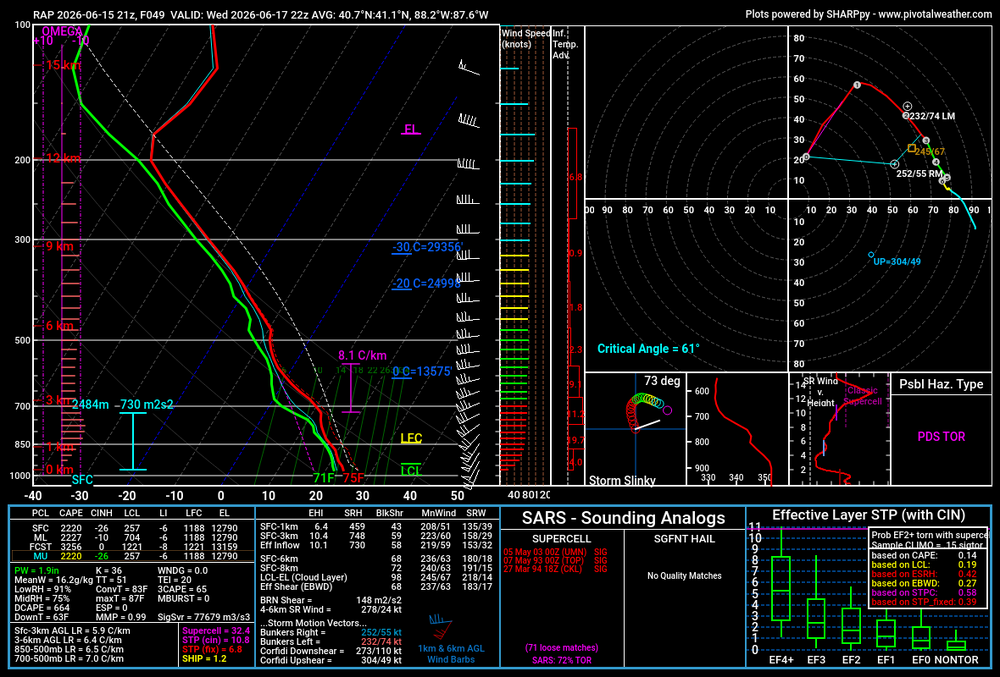
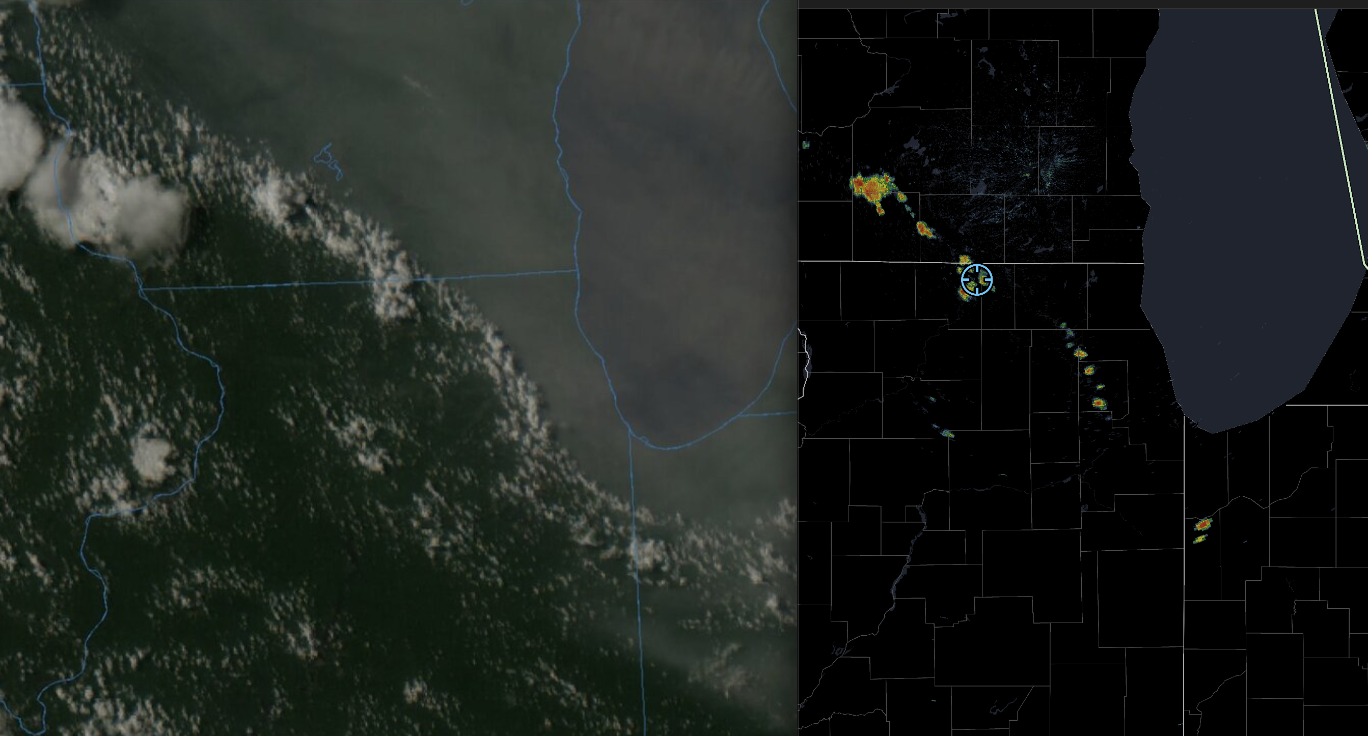
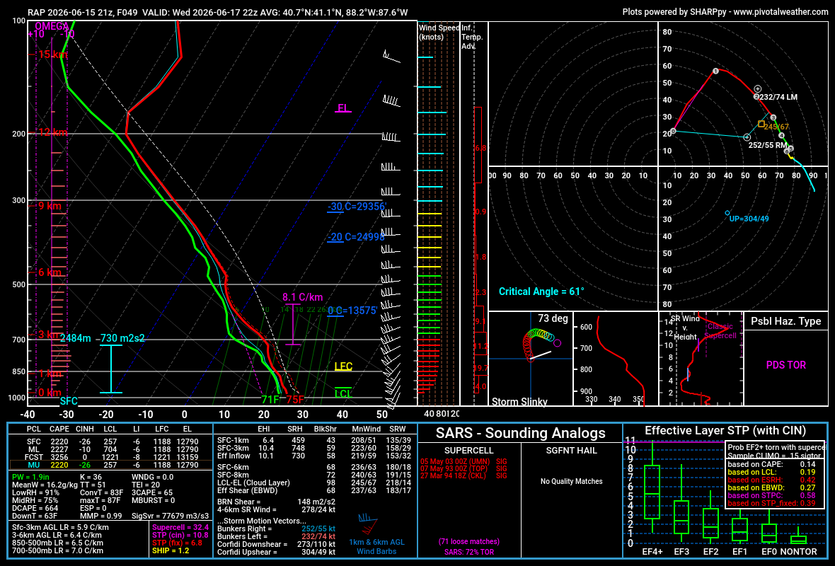
21Z RAP box soundings are nuts. 730 m2/s2 inflow layer SRH.
-
18Z NAM and RRFS-A (I know, I know, but they're the only mesoscale models that go out that far) edged a little bit north with the warm sector for Wednesday evening.
-
I couldn't chase last Thursday due to being in Cleveland on a family trip (probably would have ended up on the still-tornadic relative junk in western IL anyway), but it'd be nice to have the target not be south of I-80 for once since I rarely can take PTO on short notice from my job.
-
1
-
-
Annoyed I will be missing the severe threats in MBY due to a planned trip to Cleveland to visit family tomorrow through Friday.
-
Models give some hope for a return to activity on or about June 14-15, at least for northwestern portions of the sub. Will have been a very long four weeks by that time.
-
1
-
 1
1
-
-
It really seems like a mixed bag with ENSO. Feels like in my adult life we've had wet Ninos, dry Ninos, wet Ninas, dry Ninas, warm Ninos, cold Ninos, warm Ninas (most dramatically 2012), and cold Ninas. The strength and timing/speed of transition (TNI) makes the biggest difference.
-
1
-
-
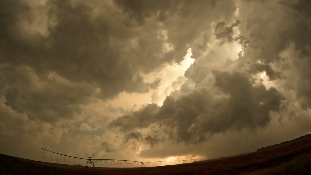
Reupping this thread as several months later I found a frame in my GoPro footage that shows the left edge of the Cullison-Iuka tornado. This is looking north from NW 10th Street northeast of Cullison. It literally was just this one frame, though. Too bad there wasn't more lightning back-lighting under the base. Nearly all of it was at anvil level.


July 2026 General Discussion
in Lakes/Ohio Valley
Posted
Smoke rain now. Will be interesting to see how my Corolla which is parked outside looks after this.