

CheeselandSkies
-
Posts
2,959 -
Joined
-
Last visited
Content Type
Profiles
Blogs
Forums
American Weather
Media Demo
Store
Gallery
Posts posted by CheeselandSkies
-
-
2 hours ago, Chicago Storm said:
Any severe threat up around here for Thursday vanished as quickly as it appeared.
Yup...NAM tease. The lack of prior support from the globals was always a red flag, although one can hope.
-
7 minutes ago, SchaumburgStormer said:
Yeah, seems for the good ones at this time of year we are tracking the front northwards waiting for it to get hung up along I-80, lol
Although, this year we've already had multiple
 events along/north of the IL-WI line starting in frickin' early February. It would be ironic if we started having issues with that now as we finally get into mid-March, on Daylight Time and close to the equinox.
-
12Z 3K doesn't have the WF getting much north of the IA/MO line, and rakes MO with supercells. Unfortunately that'd be out of range for me for a work-night chase.
-
1 minute ago, cyclone77 said:
Never been a big fan of these kind of setups where the east/west front starts to crash southward during the warmest part of the day, as some models show. Seems like with the good setups the warm front will at least slowly advance northward during the daytime at least.
Yup. Definitely would rather see the low intensifying with the mass response pulling the warm front northward or at least stationary.
-
Of course, right as they do that, the 06Z NAM (by far the strongest model supporting this solution) comes in with a less focused, strung out surface low.

-
 1
1
-
-
Day 3 introduces slight risk for IA/IL/MO with hatched area. Supercells with "all hazards" possible per disco.
-
NWS Quad Cities not really sold, don't even mention the NAM solutions in their afternoon AFD. Just hail potential Wednesday night and mainly a rainfall event for Thursday.
-
1 hour ago, andyhb said:18z NAM is absolutely nasty in the Midwest (IA/IL) on Thursday. Other models generally are not as favorable although they appear to be shifting towards a solution where a coherent shortwave ejects ENE/NE after Wednesday, which would increase the threat.
Very, very cold air aloft with temperatures approaching -20 at 500 mb and -45 to -50 and 300 mb means that you won't need a lot of moisture to get strong updrafts.Besides, on that plot posted above, moisture isn't even really a concern here.
500mb actually looked a little better on the 12Z, with what appears to be a negatively tilted shortwave swinging across the region at 00Z.
Sent from my Pixel 4a using Tapatalk
-
2 hours ago, andyhb said:
Blocking pattern looks to setup beyond mid month given the ongoing significant SSW and prolonged disruption/decay of the stratospheric PV (perhaps the final warming). Would think moderation of some of the warmth should occur during that period along with a decrease in severe weather chances.
Of course.

-
Scarcely a drop today, everything managed to miss just to the southeast. Looks like this next little batch coming up between Belleville and Fitchburg will, too.

-
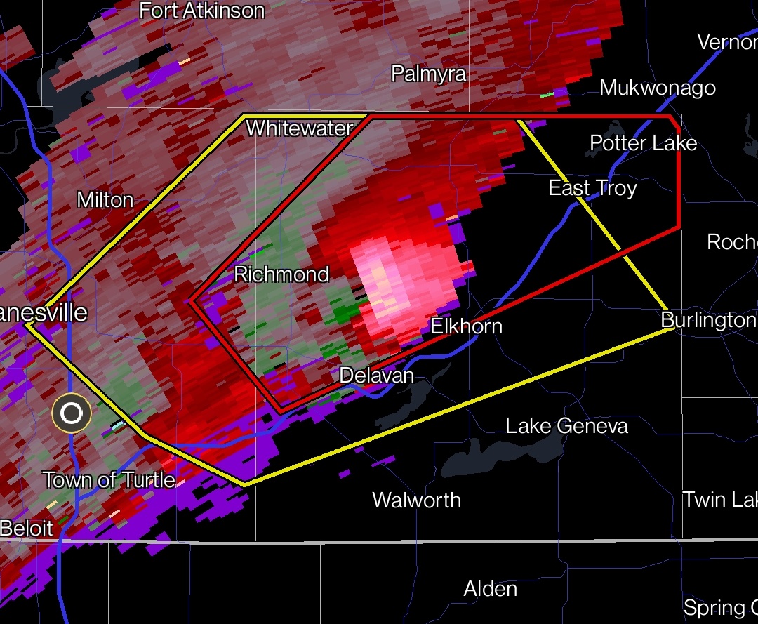
39 minutes ago, Malacka11 said:
Whoops, looks like that was LOT. Completely failed to notice that somehow
Reds are outbounds, so in that case, winds blowing to the north. Could represent a surge of inflow. Generally when one color dominates like that it's either that or RFD depending on where the radar is.
-
 1
1
-
-
52 minutes ago, Malacka11 said:
I hope this isn't a silly question to ask, but what does it mean if there's a lot of red or whatever but not green? Like a one-sided velocity signature, I guess you could say? Does that mean rotation is breaking down or something?
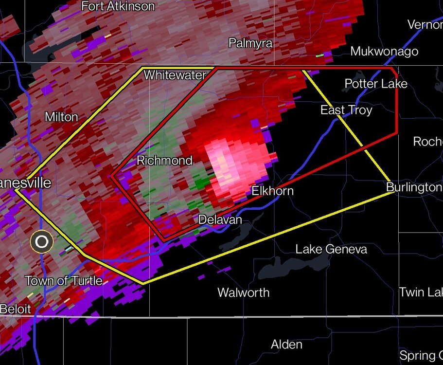
Which radar site is that? KMKX?
-
2 hours ago, Stebo said:
You shouldn't be posting a 348 hour map from an operational model. There is nothing to discuss there because it could easily change. If you want to post an ensemble mean that's fine but even then it is a day 12 map.
Also not sure why a 348 hour temperature anomaly map belongs in the severe weather thread, unless he's trying to troll?
-
Wrong thread, guys.
-
 1
1
-
-
56 minutes ago, hawkeye_wx said:
The temp is up to 78º here, with low 80s across southeast Iowa. While still low, the 47º dewpoint is 15º higher than it was last week when we reached the 70s, so it feels more springy.
We REALLY need to start getting some rain. It is very dry here.
Yeah, hope tomorrow produces.
-
Surprise Day 2 marginal risk upgrade for southern WI with 2%
delineation. Haven't looked too deeply into it but the way this "winter" is going around here, anything is possible.
-
Yeah, as I said hope those CPC precip outlooks posted in the spring LR thread verify, although would like to see green extending into even more of IA/WI/MN.
-
5 hours ago, A-L-E-K said:
hard to complain too much about all that^
*assuming we've all punted on flake
Would like to see more of the AA precip chances extend into WI/northern IA/MN/SD, but I'll take EC. +temp/-precip is no bueno.
-
2 hours ago, Chambana said:
hardyfruitguy
Don't give him any ideas.
-
 1
1
-
-
Still blew the daily record out of the water, but I don't think we'll get as warm as earlier thought (pretty sure I saw some 71s or 72s in the forecast) because we were expected to get more sunshine this afternoon.
-
2 minutes ago, KeenerWx said:
Wonder if locally this is the earliest 10% hatched tor outlook.
Would beat 2/28/17 by a day, lol.
https://www.spc.noaa.gov/products/outlook/archive/2017/day1otlk_20170228_1630.html
-
1
-
-
1 minute ago, Stx_Thunder said:
Normally the risk of all severe hazards is virtually non-existent in very elevated or high-based storms.
It's true that it's difficult for tornadoes and damaging winds to occur when storms are not surface-based, but the elevated significant hailer is very much a thing.
-
1
-
-
15Z HRRR started to downtrend the impressive supercells the earlier runs had across northern Illinois, and 17Z effectively loses them entirely.
-
1
-
-
42 minutes ago, Stevo6899 said:
Thanks for the reply/info. I always thought sunshine early is good to help with instability and help with moisture and severe development but as always there's so much going on and things to look at and it only takes one component to mess it all up.
That's true in a broad sense, but too much of a good thing is possible when you are dealing with shallow moisture.
Spring/Summer '24 Banter and Complaint Thread
in Lakes/Ohio Valley
Posted
Eight years ago today, a localized tornado outbreak occurred across central Illinois. Synoptically the setup was pretty classic with the left exit region of the midlevel jet squarely over the area and a deep surface low. However marginal/"just-in-time" moisture was an expected issue with dewpoints only reaching the mid-50's by go time. However with cold air aloft and the excellent kinematics, it was enough. Although, my chase partner and I thought our tornado chances were done for the day when we pulled into the Casey's gas station on IL-116 at the west edge of Hanna City, ahead of the "tail-end Charlie" cell on the next cluster of storms north of the one that would produce the tornado just west of Springfield around the same time. The storm wasn't looking that impressive on radar and our plan was to gas up, get snacks and drinks, and let the storm roll over us, sheltering his car under the gas station canopy if there was hail and then shoot lightning on the back side on the way home (I never uploaded any of the video from before the tornado encounter until now, I'd forgotten how electrified the storm already was at that point).
It was at this point that several things happened in rapid succession. We felt a gust of warm inflow toward the storm still off to our immediate west (when, based on the prior radar presentation, we were expecting cool outflow), which should have been an "Oh s***!" moment but we just kind of shrugged it off "huh, that's interesting." What we didn't know was that the storm had just undergone a constructive cell merger. The radar updated to reveal, while not quite a classic hook on reflectivity, a definite RFD gust front curling back into an inflow notch, with an intense velocity couplet colocated with it, just off to our northwest! Both our cell phones alerted simultaneously with a WEA for a tornado warning, and the town's sirens blared to life! I'll let the video and its accompanying description tell the rest of the story...
I'm conflicted about counting this as my first tornado, since we weren't 100% sure of it in real time, and it cannot be confirmed from my imagery alone due to the intervening tree line at the ground. NWS ILX surveyed a 7.1 mile path of up to EF2 damage from northwest of Trivoli to north of Hanna City that matches up with the time and direction of our view. This was one of three EF2 tornadoes to occur with the event; the best-known is probably the earlier one that occurred near Good Hope.