

CheeselandSkies
-
Posts
2,959 -
Joined
-
Last visited
Content Type
Profiles
Blogs
Forums
American Weather
Media Demo
Store
Gallery
Posts posted by CheeselandSkies
-
-
Yeah, even on another weather forum I suggested that some people throttle back the hype train a couple days ago, mainly due to the consistently progged steep positive tilt of the main trough and had them jump down my throat because "p0siTivELy tilteD TROughS can STIlL pr0duCe MajoR TOrNaDO events."
Well, yeah...BUT it is a lot less likely than with neutral to negatively tilted troughs. I can't confidently say that the mitigating factors we saw with today (and yesterday's) events were direct results of the positively tilted trough, but some (such as boundary-parallel flow promoting junk convection, and the best forcing and cold air aloft lagging behind the warm sector), seem to be common to them.
-
 1
1
-
-
1 hour ago, madwx said:
Still rain here for now. Hoping it stays rain as long as possible to cut down on accumulation
At least there should be an explosion of green when the weekend/early next week warmup finally hits.
-
2
-
-
12 hours ago, OHweather said:
Broyles has gotten better over the years and usually the SPC is pretty good about not whipping around the outlooks too much, but I don’t think anyone was very happy with the initial Day 2 outlook this morning to say the least
Broyles on today's 4-8:
QuoteThere is still considerable uncertainty on Saturday, mainly due to the lack of low-level moisture and instability.
SO WHY DID YOU INTRODUCE AN AREA????!
-
 1
1
-
-
48 minutes ago, andyhb said:
Outbreak potential with intense/long-tracked tornadoes mentioned in that outlook.
Well that was a change-up.
-
5 hours ago, madwx said:
Straight up not having a good time
I'm just gonna enjoy the nice rain we're having right now.
-
Video is now live:
-
3
-
-
5 minutes ago, hawkeye_wx said:
We had some decent lightning/thunder this evening, but no rain.
Here's hoping Monday is as much of a washout for IA/NW IL as it looks to be on the GFS.
-
16 hours ago, Floydbuster said:
I mean "springtime" figuratively speaking. Most people consider "springtime" pretty much Valentine's Day to Memorial Day. March has flown by.
Fair enough.
-
I have a premiere set up for my 1-year anniversary re-edit/upload of my Keota chase video. Sunday 3/31 at 8:30 AM CDT.
-
1
-
-
4 minutes ago, nvck said:
30% added to the D4 outlook for Monday, with most of the Southern area of the sub under a 15%. Does this mean that tomorrow's D3 outlook will more likely be slight/enhanced, or marginal/slight?

The probabilities on the Day 4 and beyond outlooks don't have a direct correlation to the Day 3 and closer. The 30% zone is for all hazards. For an Enhanced risk, the wind OR hail probability has to be 30% OR the tornado probability of 10%. So it all depends on how things trend and how confident they are.
They treat the longer range outlooks a little differently than they used to. Nowadays, they'll introduce a 15% at Day 6 if they're reasonably confident in an at least 15% probability of wind or hail (slight risk) maintaining itself by Day 1. Twenty years ago, if you saw a 25% (then used for a "high-end" slight risk, what would be an Enhanced risk today, the minimum threshold for a slight risk was 15% just like now) contour on the Day 3 outlook, it implied above-average confidence in a widespread/high-ceiling threat and a good chance of a high risk popping up at some point on Day 1.
-
 1
1
-
-
Ahead of the 1-year anniversary of the 3/31/23 outbreak, NWS Quad Cities has put out a video breaking down the setup for the outbreak in their CWA, including the Keota etc tornado family. One of the frame grabs I sent them is in the graphic at 4 minutes (and on the thumbnail).
I was diving a little bit into the archived SPC data earlier this week, and DVN's summary here jives with my impression that this event was surprisingly thermodynamically driven for an early-season Midwest setup. While certainly more than adequate for significant tornadoes given the other conditions in place, the low-level shear (at least in terms of raw SRH values) in this area wasn't jaw-dropping by high-risk, violent tornado outbreak standards. What really put this over the top IMO was the 3CAPE and lapse rates, as well as nearly optimal streamwise vorticity ingestion per the hodograph allowed for maximal use of what spin there was in the atmosphere.
-
5
-
-
8 hours ago, Floydbuster said:
Spring is flying by and they're going bonkers.
The equinox was only a week ago, lol.
-
Primary severe threat with early next week system looks to remain southwest of the sub on Monday, with steep positive tilt mitigating things going into Tuesday, but it should bring a considerable amount of rain to a large area.
-
4 hours ago, KokomoWX said:
The GFS has been brutal with cloud cover.

Oof.

-
 1
1
-
-
2 minutes ago, Floydbuster said:
I'm a hurricane guy so I'm not seasoned in severe weather and I don't storm chase but these people are drooling and begging for a severe event. Spring is flying by and they're going bonkers.
It's actually quite annoying.
Well, I am a chaser and I do love severe weather, but I advocate for restraint on social media hype unless/until there is actually good model agreement/consistency for a high-ceiling threat.
-
1
-
-
2 hours ago, largetornado said:
Every time Weed sees a trough on the models, he drives the social media hype train out of the station at full throttle, derails, crashes, and burns.
I remain skeptical of this timeframe due to inconsistency between models/runs. Could it turn into something big? Sure, but IMO it's just as likely at this point to be a relatively modest event with a lot of rain/general thunderstorms and some isolated severe weather.
-
So when I got to work this morning the thermometer in my car said 27 degrees, and we had a stiff west-northwesterly breeze. 7-day forecasts from my employer and the NWS are rather depressing, with nothing outside of 40s and 50s. When's the flip back to much AA?
-
1
-
-
DMX with a great AFD write-up on all the potential impacts of the Sunday-Monday system including severe and synoptic winds. DVN/ARX seem purely concerned with snow despite the potential for the narrow instability sweet spot to set up at least partially in one of their CWAs.
QuoteRight on the heels of this lighter precipitation will be strong warm air/theta e advection ahead of a synoptic scale system bringing much needed precipitation to the area. This system checks a lot of the boxes, with good kinematic and thermodynamic support throughout the layer. Moisture also won’t be an issue, as the pacific moisture stream mentioned earlier will phase with a developing lower level moisture stream from the Gulf of Mexico. As the broad scale lift helps to induce widespread precipitation, there will also be localized FGEN support on the leading edge of the warm air advection stream. So what’s this all mean for sensible weather? Well, as the theta e advection pushes into the state on Sunday morning, cooler temperatures will initially cause moderate to heavy snowfall in roughly the northern half of the state with rain further south. However, as the warmer air and higher dewpoints stream north, this snowfall will quickly flip over to rain for much of central Iowa by mid-day Sunday. As this transition occurs, it’s possible some will see a brief wintry mix before rain takes over completely Sunday afternoon, although no impacts are expected due to an icy precipitation. The warmer temperatures will arrive in northern Iowa the latest, and therefore the highest snow totals are expected near the Iowa/Minnesota border and north. For those further south, snow may initially accumulate on cooler surfaces, but rain falling on top of snow, as well as higher temperatures and dewpoints should quickly melt any snow on the ground. This snowfall distribution is pretty unanimous across the current deterministic and ensemble output, as the trend in guidance leans towards a deeper, more amplified system pulling more warm air into Iowa sooner on Sunday, and therefore a northern trend in the higher snowfall totals. The fun doesn’t end after Sunday, as the surface low pivots over eastern Kansas and Nebraska late Sunday night, then tracking through western Iowa on Monday morning. As mentioned previously, the trend in guidance has been towards a deepening and more amplified system, which has slowed the low and pushed it further west, placing the warm sector over much of central Iowa. This trend not only leads to continued precipitation into Monday, but also poses the risk for some stronger thunderstorms mid-day. While it is still too far out to get too bogged down in the details, this setup looks to be your typical early season low CAPE, high shear scenario. Models are starting to hint at a pocket of 500 to 700+ J/kg of surface based CAPE within the warm sector as well as more than enough shear to produce an organized storm or two. Again, not going to dive too far into the possibilities at this time, especially as the threat looks somewhat conditional on how much instability is present. However, keep the potential for severe weather in the back of your mind as we get closer to Monday. Finally, not to be overshadowed by the rain, snow and thunderstorm chances this weekend, this system will also be quite wound up, meaning tight pressure gradients and gusty winds. EPS ensemble wind gust statistics are quite impressive, with a mean wind gust magnitude of 35+ mph on Sunday and up to 45 mph on Monday. This is corroborated by GFS and NAM soundings mixing up to 800 mb with 50 kts at the top of the mixed layer on Monday. NBM seems to be handling this well for now, putting gusts over 30 kts both days and over 40 kts on Monday. Should this trend continue through future forecast cycles, wind headlines will likely be needed for one or both of these days, but will hold off on that for now.&&
-
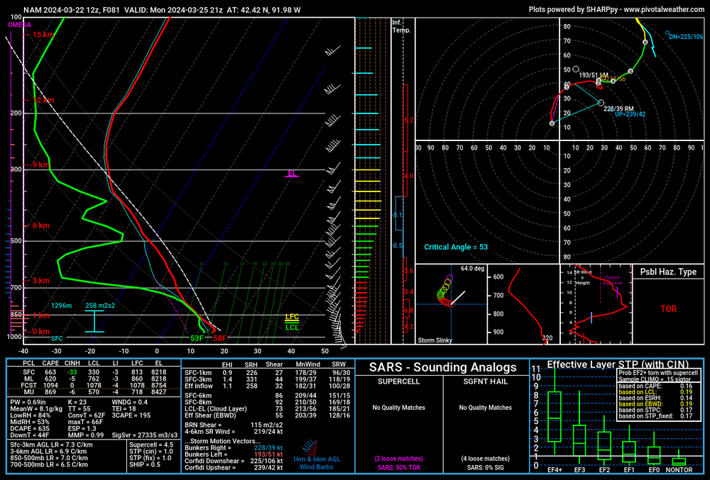
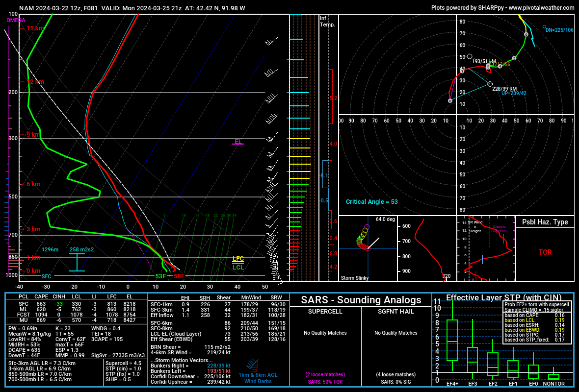
SPC's highlight is much further south, but the 12Z NAM (and most antecedent GFS runs up to this point) would certainly support a severe/
 threat in a narrow arc across eastern Iowa Monday afternoon. Those hodographs and 3CAPE are something else, if not for the antecedent Gulf drying, I really think we'd be staring down the barrel of another significant late March outbreak. The one thing I will say is that the surface low appears to be weakening with time on Monday; whereas last year March 31 it was deepening or at least holding steady. That might have mitigated the overall threat some in any case, but even so that's a pretty impressive profile despite the paltry on their face T/Td values. You only have to go back one more year (and in the very same state no less) to see what can happen when a setup like that overperforms.
-
51 minutes ago, madwx said:
I'm going to be straight up not having a good time tomorrow
Same.
-
55 minutes ago, Chinook said:
METARs? What METARs?
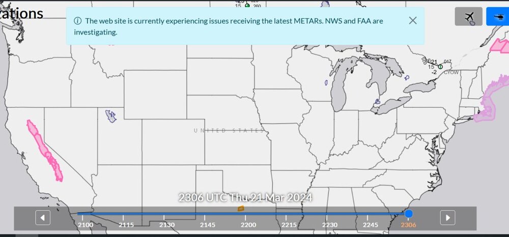
We don't need no stinking METARs!
-
5 hours ago, madwx said:
things look to turn mild once we get into April. Maybe a few cool days at the beginning of the month but should turn nice after that
Based on what guidance, out of curiosity?
-
1
-
-
5 hours ago, largetornado said:
Based on the GFS over the past 4-5 days, looks like our next chance of severe is going to be 3/28-4/3.
Some moisture issues to sort out, but quite a bit of potential there *if* things trend favorably.
-
7 hours ago, hawkeye_wx said:
I'm really liking the medium to long range. Ensembles are spitting out widespread 2-3" of precip across the region through 15 days as big troughs eject out of the west and the gulf is wide open.
Sounds like that would mean more
chances, as well although of course the crucial specifics of any one setup are hard to pin down at this range.
GFS has been less enthusiastic about the "open Gulf" idea, as it has been pretty consistently spinning up some sort of southern stream low in the Gulf that runs up the East coast, with its associated cold front plunging south and scouring out the moisture. However it could be completely out to lunch with this. Seen it lock onto a particular idea (such as formation of a TC in the western Caribbean) for something like 120-150 hours worth of runs only for it to not happen.
Edit: The feature I talked about is still there in the incoming 00Z run. FH111, 1007mb coming into the Florida Big Bend and then runs up the coast, dewpoints get dropped to the 50s across most of the Gulf (even upper 40s along the Florida Panhandle coast).

4/1-4/2 severe threat (southern portion of subforum)
in Lakes/Ohio Valley
Posted
Probably a little of both. The comparisons to 1974 and other ultra high-end outbreaks were ridiculous. This had nothing in common with those other than the general area at risk. Vastly different mid-upper level setup than that which has historically produced the top-tier outbreaks.