

CheeselandSkies
-
Posts
2,959 -
Joined
-
Last visited
Content Type
Profiles
Blogs
Forums
American Weather
Media Demo
Store
Gallery
Posts posted by CheeselandSkies
-
-
We ready to kick off the 2024 severe weather discussion thread on February 6th?
 Although, there have been tornadoes in northern IL in early January (2008), and in mid-December in northern Wisconsin (2021), so anything is possible.
-
 1
1
-
-
16 minutes ago, andyhb said:
Lol the RRFS is doing some... things in E IA/W IL tomorrow.
Just saw that on TalkWeather. Although it's actually for the timeframe valid for Thursday evening (and unfortunately, after dark this time of year).
-
9 hours ago, Lightning said:
Amazing season. Yes that sucked but IMO I think KS would destroy our secondary in the SB (not the same KS team of week 1). I think 49er are better built to stop them. For me, this will only hurt if Detroit collapses going forward and doesn't grow from it which I don't see that happening. Players actually want to come to Detroit (don't think I could ever say that in all my years)!! Our OC is staying (could have been a HC). I know there are no guarantees in the NFL but I believe there are actual good signs going forward. That my 10 cents about the whole thing

See you twice next season. Should be good games. Otherwise, 4 wins apiece against the Bears/Vikings sounds like a plan.

-
 1
1
-
-
You'd think with all these AA temps we could at least get a winter
 outbreak, but nope. Trough coming through Saturday on the GFS is negatively tilted to the point of absurdity, with southeasterly flow at 500mb, and despite low 50s dewpoints all the way up to southeastern Nebraska, 60s remain offshore the Gulf coast!
-
1
-
-
15 minutes ago, Stebo said:
Yeah that area and places to your north and west are really in trouble with how dry it has been.
Alberta has really been suffering through a prolonged drought.
Don't like that. Don't want to see more fires/smoke.
-
13 hours ago, torchcity said:
Well looks like winter is over. Hope everyone enjoyed the last two weeks. Palm tree weather is back and this is the new normal. So get used to it. Soon those two weeks won’t even happen.

-
 1
1
-
-
On 1/19/2024 at 9:53 AM, madwx said:
this system is really conflicting with my mental model of what a snow or ice storm would look like for this region. Not to say it won't happen but it just seems strange to have a 1018 mb low with nothing impressive upstairs dump so much precip
From yesterday's afternoon AFD, MKX didn't seem to concerned about ZR in our neck of the woods. Just wet snow turning to rain.
-
3 hours ago, madwx said:
Just took my first drive outside the neighborhood after the storm and besides highways the roads are 90-100% covered in snow and ice. With the cold air it should be staying like that for the next week
Yeah, not looking forward to the drive to and from work Tuesday (my weekend is currently Sunday-Monday); even though coming home Friday and going in Saturday morning weren't as bad as I'd feared.
-
19 minutes ago, RyanDe680 said:
LOL.
Top post of the thread
No, that was this one by @SchaumburgStormer
-
1
-
-
May have been posted already, but blizzard MD out for Iowa.
https://www.spc.noaa.gov/products/md/md0056.html
SPC spending more time on winter wx today than anything within what was that Day 3 Enhanced they put out on Wednesday. @andyhb
-
1
-
-
9" as of 20Z at McFarland, WI (near Madison) per a Cocorahs report on GR Level 3.
* Between forecasting and nowcasting; people getting hit posting updates and people complaining they are getting missed/rain, I think this is by far the hottest winter event thread for this sub since I've been on this board (winter of '17-'18 would have been my first here).
-
Had to take my Corolla to work today since my wife with her 4WD SUV also had work this morning. Almost got stuck trying to make a right turn due to all the compacted slop piled in the intersection, fortunately I was able to reverse out and take an alternate route. Also, don't be the guy in front of me in the thumbnail.
-
1
-
1
-
-
Getting dry slotted here in south-central WI. First round turned the Interstate near the state line into a s***show.
-
1
-
-
-
14 minutes ago, Malacka11 said:
The old Tornado Intercept Shitbox and I had quite the time in the slush the other day. Tomorrow will give me a run for my money...
Safe travels!
-
1
-
-
4 hours ago, madwx said:
full sunshine right now. happy to sneak this in before the next system starts spreading high clouds in
Helped clean the secondary roads up a good bit ahead of the next round. Me and my FWD sedan will appreciate that as my commute is short but follows a quite hilly, curvy road.
-
MKX now has a warning out for all of their counties.
-
Timelapse from my porch window yesterday afternoon:
Shameless plug, please subscribe to my new YouTube channel (deleted my old ones in September). I'll eventually be re-uploading my Keota
and other weather-related footage there.
-
1
-
-
7 minutes ago, madwx said:
We've been close to or in the sweet spot with this one for a while...and surprisingly that hasn't really changed.
Should be interesting when I'm trying to leave work around midday Friday.
@madwx I just realized how similar our avatars are ever since I changed mine to a frame from my Keota tornado video; horizon and debris cloud are at about the same level, only difference is my foreground is drab brown since it was taken in March.
-
1
-
-
13 minutes ago, Radtechwxman said:
If you're trusting hrrr at this range the joke will be on you. Lol. It did terrible at this range with previous system.
Not trusting it, merely commenting on it.
-
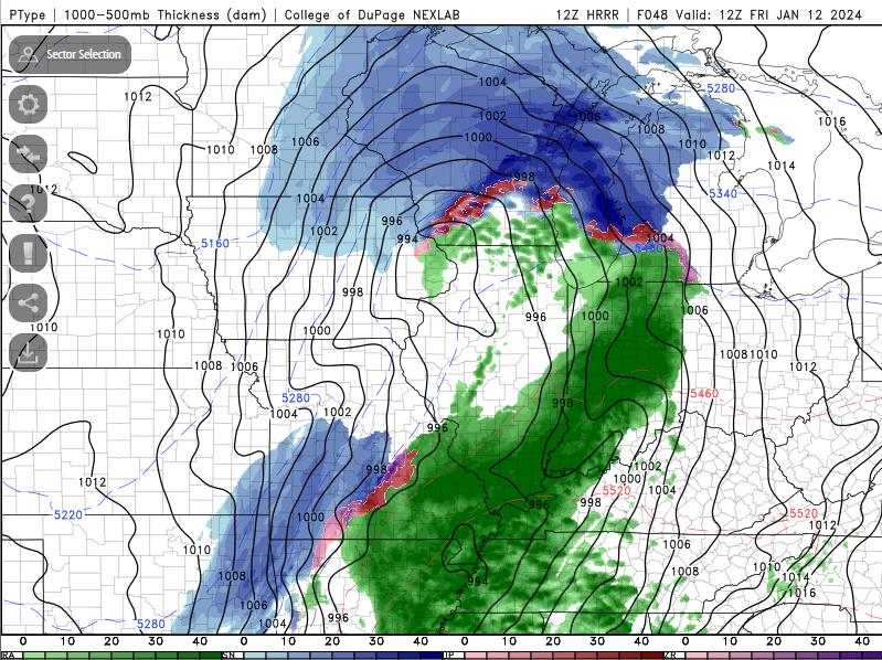
That 18Z HRRR gives some parts of southern WI and far northern IL nearly 1" in an hour toward the end of the run with the snow far from over. Sorry, south of I-80 (possibly even I-88) folks.
-
12Z Euro deepens 8 MB in 6 hours, from 981 at 18Z Friday to 973 at 00Z Saturday. Wasted QPF, bad ratios or not, a storm of this intensity is going to have significant, varied, and dangerous impacts across a large area. There could even be a storm surge in much of New England/Long Island with that strong, broad southerly fetch blowing into the low Friday night.
-
4 minutes ago, SchaumburgStormer said:
Stop me if you've seen this before, but the NAM is a north outlier.
Not as much as the HRRR, though.

-
Just now, madwx said:
Congrats La Crosse
There's always gotta be one...
February 2024 General Discussion
in Lakes/Ohio Valley
Posted
RRFS actually holding serve on subsequent runs. Marginal risk introduced.