

CheeselandSkies
-
Posts
2,969 -
Joined
-
Last visited
Content Type
Profiles
Blogs
Forums
American Weather
Media Demo
Store
Gallery
Posts posted by CheeselandSkies
-
-
59 minutes ago, Holston_River_Rambler said:
I've been waiting for one of these big red/ yellow surges to show up on these maps. Hopefully it makes it back to our hemisphere.
I REALLY hope this verifies.
-
 1
1
-
-
GFS and Euro OP don't look too encouraging if you want warmth and storms in the Midwest. Shows a return to western ridging with the lowest 500mb heights across the eastern Lakes.
-
MKX now with a WWA out for freezing rain, and it's actually started to snow here. Earlier they weren't expecting anything other than rain.
-
27 minutes ago, JMT417 said:
Also Tor Probabilities lowered
Of course.
-
Tomorrow isn't as clear-cut as it once looked, but if the midweek system has instability problems (which 12Z GFS suggests it will) it won't be for lack of moisture....
-
7 hours ago, BrandonC_TX said:
I'm now getting a bit more intrigued about the storms that should take place overnight from tonight into tomorrow morning. SPC put up a risk for significant hail (15% hatched) from the DFW Metroplex to the I-40 corridor in eastern Oklahoma, and a 5% tornado risk NE of DFW. Models are showing significant VBV for DFW/North Texas in particular, though. But it seems that the tornado risk should be highest tomorrow (3/8) over the Mississippi Valley in the Mid-South region per SPC's issuance of a Day 2 Enhanced risk there (in the "maximum risk by hazard" section of their Day 2 write-up SPC is preliminarily going with 10% hatched).
12Z 3K NAM spitting out some robust UH tracks over central OK around 09Z overnight. Not sure if they'd be surface-based but should be at least a hail threat.
For later Saturday on the 12Z GFS...woof, at 500 mb that trough really has the look of one that produces tornadoes, but according to it and other models the instability just isn't going to be there except across a small part of the Deep South well removed from the best dynamics and wind profiles.
Save these for May please (although systems like this CAN get it done in mid-March or even earlier - 3/13/90, 3/12/06, 3/15/16, 2/28/17 etc - this doesn't look like it's going to be one of those times).
-
I won't be seeing that for another month at least.
-
3 minutes ago, AfewUniversesBelowNormal said:
Big difference between the GFS and Euro right now.. especially with regards to timing.
For Saturday, or mid-next week?
-
32 minutes ago, CryHavoc said:
Thanks. Could you link/attach some of the new soundings? I haven't seen the veer back, but I haven't really had the time to take a look at them.
Here's one from the 12Z NAM valid for 21Z Saturday from the zone of greatest progged 0-1KM EHI along the MS river/AR-TN border region. Looking at the wind barbs the veer-back isn't as pronounced as earlier runs, but there's a very slight amount of backing from 850 up to 700mb, but moreover the winds look pretty unidirectional albeit very strong at all levels. Even so, there are ample amounts of SRH and EHI depicted.
The wind profile is depicted as much more classic (southerly surface winds, veering to SW at 850mb and WSW at 500mb) farther east near the MS/AL border, but instability is progged much weaker there.

-
Doubt it because it's a relatively small area with high CAPE, and there are some VBV issues apparent in soundings. Still verbatim the potential for an isolated nasty event like last Sunday's EF4 is apparent should a storm find a sweet spot.Day 3 still slight risk.
Somewhat surprised given the moisture content and returns on the hodographs. I guess Day3 MDTs are pretty rare, but this seems to be a good synoptic setup.
Am betting on a Day2 MDT. Anyone think this could go HGH day of?
Sent from my SM-G955U using Tapatalk
-
1
-
-
This looks like one of those (rather common) scenarios where, counterintuitively, a (relatively) weaker system leads to higher impact wx. There seems to be a point, usually around 990mb, where except in rare cases further deepening does more harm than good if you want to see winter and/or severe wx (at least when the SLP is still centered west of the MS river). Those "inland hurricanes" that are down in the low 980s or below typically just bring blustery cold rain to locations not on the Lakes, and the big time snow occurs in the northern Plains.
-
On 12Z NAM, hodos are looking very impressive over the AL/MS border region (moreso than further west where instability is greater). Could be another scenario to watch out for prefrontal initiation in that area (as with last Sunday) if it can destabilize.
Sounding attached is from a small pocket of higher CAPE depicted near and south of Columbus (ruh roh), MS. I see some slight backing on the wind barbs between 700 and 500 mb, but that doesn't look like game-breaker levels of VBV.
-
2
-
 1
1
-
-
Remember when this was a guaranteed all-rainer for S. WI/IA/IL?

-
Looks like 12Z NAM want to blitz us with ZR. Fun times.
-
Sooooooo I was promised a pattern flip following this miserably frigid start to March. Now I'm hearing in the SE forum that it's supposed to stay cold the rest of the month? What devilment is this?
-
Arrrrgh. What happened to the advertised flip after the frigid start to March?
Also, where is this supposed cold coming from? Was there another SSWE without anyone noticing?
Sent from my SM-G955U using Tapatalk
-
Another one of those times I'd like to bottle and save this pattern for May. Watch these systems be moisture-starved and then we're stuck in a blocky eastern trough pattern for the balance of May.
-
Yep looks like a northern MN/WI special at this point. Over the weekend the GFS raised my eyebrows a bit with a swath of 6"-12" going right over the IA/MN border, across southern WI, and central/southern lower MI.
-
Well, yesterday certainly broke the trend of a lack of violent tornadoes and few fatalities, unfortunately. We'll see if that translates into a better year for chasers or just more destruction and misery.
-
1
-
-
Holy ****. Haven't heard of debris lofting like this since the two days in 2014 (Vilonia/Louisville) and before that, 4/27.
-
2
-
1
-
 1
1
-
 1
1
-
-
2 minutes ago, MattPetrulli said:
That's a sizable TDS looking to impact areas between Montellico and I-10.
Edit: That may occlude right into Montellico.
New tornado warning issued that includes Monticello. Original polygon was oriented more to the ESE.
-
5 minutes ago, MattPetrulli said:
That's a mean debris signature approaching Talbotton.
Yikes, I would say that would have warranted a TORE.


-
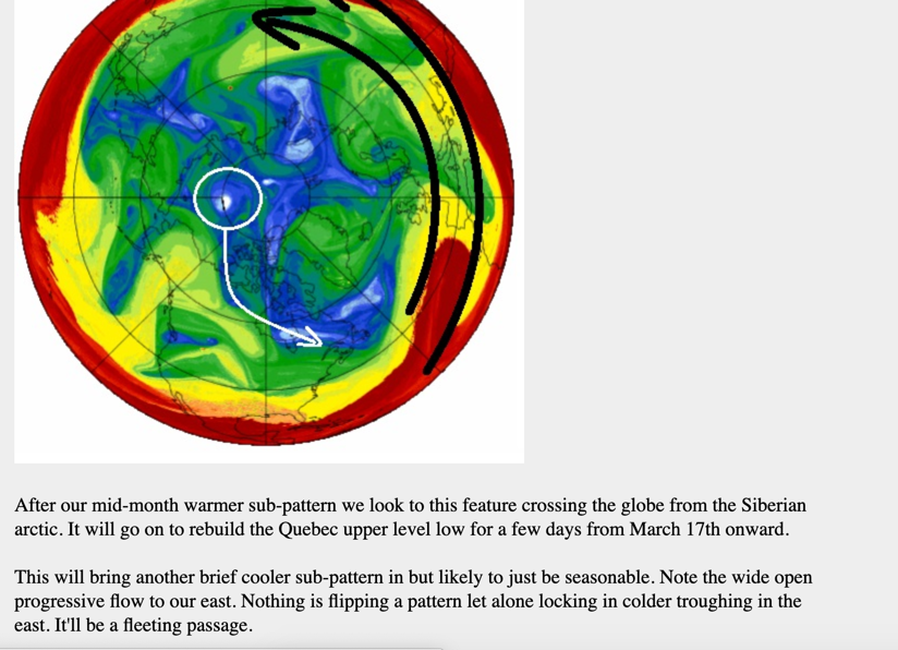
12Z GFS has a gnarly beast of a system for next weekend. Broad, quality warm sector with lapse rates exceeding 8 degrees C/km in parts of Dixie Alley, heavy snow across parts of IL/IA/WI/MI. If it and the other models can keep that general look for a few more runs, it's going to be a fun week. Something to take my mind off how **** cold it's going to be, at least.
-
Since no one else has yet, I'll point out that there's a Day 4 risk area out for much of the TN Valley/Dixie Alley region. As usual still a lot of pieces to come together as to exactly how this will play out. Could be about as significant as last Saturday, or more, or less. Worth noting though since model trends have been upward for the possibility of severe weather in the area on Sunday.
-
2
-
1
-


List your Strongest Tornadoes ever
in Lakes/Ohio Valley
Posted
The Extreme Planet blog series is a great resource on violent tornado history, I wish he'd post more stuff again.
I agree with most of Madwx's list, except I would move Andover further down (It was rated an F5 which means it was undoubtedly exceptionally violent, but nothing in particular stands out to me about the damage it did) and replace Greensburg with Parkersburg 2008, which left some extreme debris granulation and wind rowing. I don't doubt Greensburg was a legitimate EF5, but I don't think it was quite as violent as some of the likely-underrated F4s you mentioned, plus certain EF4s of recent years (Tuscaloosa 4/27/11, Chickasha 5/24/11, Vilonia, AR 4/27/14 are my top three underrated should-be-EF5s).