

CheeselandSkies
-
Posts
2,991 -
Joined
-
Last visited
Content Type
Profiles
Blogs
Forums
American Weather
Media Demo
Store
Gallery
Posts posted by CheeselandSkies
-
-
Here we go! Big flakes, blowing in almost horizontally from the north.

-
 1
1
-
-
Can't remember the last time MBY was included in an SPC winter wx MD. Currently just rain at MSN as we're still hovering just above freezing.
-
Perhaps a better SPC-related measure of yearly severe activity compared to high risks would be watch count. I was just looking through the archives and every year after 2012 has had fewer than 600 watches issued (tomorrow's slight risk is the last chance to get 2018 to a whopping 450). They issued 699 in 2012 and at least 800 every other year since (and including) 2000 other than (rather surprisingly, since I remember both as active years) 2007 and 2010.
I think part of the drop-off can be explained by better forecasting (fewer unnecessary/"busted" watches, although they do still happen!), but there seems to be a clear drop-off in overall severe activity most of this decade, with fewer extended patterns favoring multiple moderate to high-end events like May 3-10, 2003, May 21-30, 2004, much of late May and early June 2008, or much of April 2011. Instead we see extended periods of synoptic patterns generally unfavorable to central CONUS severe weather (eastern troughing) locking in during much of what should be peak season.
-
I don't even know what to think at this point. I had higher hopes for 2018 because we were supposedly in a La Nina going into the spring, but it didn't help. Was it just the ill-timed SSW event that killed the spring, or was there more to it than that? The winteristas say there is a SSW event ongoing right now which is going to save the season for them, but my only concern is that it's not happening at a point where the effects will still be felt into, you know, May?
Number of tornadoes: 1000No high risk. Going to continue the streak that goes back to after June 2014 (since none of the four in 2017 should really ever have been issued, except maybe the one in January had it not covered so much of peninsular FL where VEERED WINDS were an obvious issue, although they honestly would have been just fine sticking with the MDT risk of the initial outlook) and I don't see anything that is going to flip the table in favor of more higher end events.
-
Well in *theory* a +3 or 4 degree departure from average, in January, in Wisconsin, is still cold enough to snow...in *theory.*
-
Not the Cotton Bowl itself - that's tomorrow. The delayed/cancelled game was the Heart of Dallas/First Responder Bowl, which was being held at Cotton Bowl Stadium.
-
The safest area was bang in the middle of the "enhanced" risk. Calendar still says 2018, for 4 1/2 more days.

-
Several cells in the Waco vicinity have the "look" on reflectivity, but no warnings as of yet.
Sent from my SM-G955U using Tapatalk -
1 hour ago, Frog Town said:
Alright! Is this what we all have been waiting for so "patiently"??
From:
000
FXUS63 KIWX 261120
AFDIWX
A sudden stratospheric warming event began over the north pole
region this week and this often sends a delayed arctic intrusion
plunging into the mid latitudes. 00z models seem to be picking up on
this with a dramatic shift to a possible arctic intrusion in
the day 7-10 period. 00z long term models have all come in very cold
for day 7 and beyond with general differences in strength and timing
of this cold air intrusion. Signal is there in most guidance and
blends with highs on New Years day or just after likely only in the
lower to middle 20s, possibly colder depending on timing. Could be a
decent lake response given increased instability but low to mid
chance pops in lake favored areas for now. Will also have to watch
closely energy ejecting out of southern jet stream. At this time,
this energy moves east just ahead of northern stream arctic
front. However, faster and more northward ejection of this feature
and its associated moisture could lend to more phasing and possible
storm system with this arctic front. Will be watching closely.
Well good thing it is happening now so the effects will be wearing off by chase season. Last winter's SSW came in I believe February which was just in time to bollox up spring but good.
-
13 hours ago, Geoboy645 said:
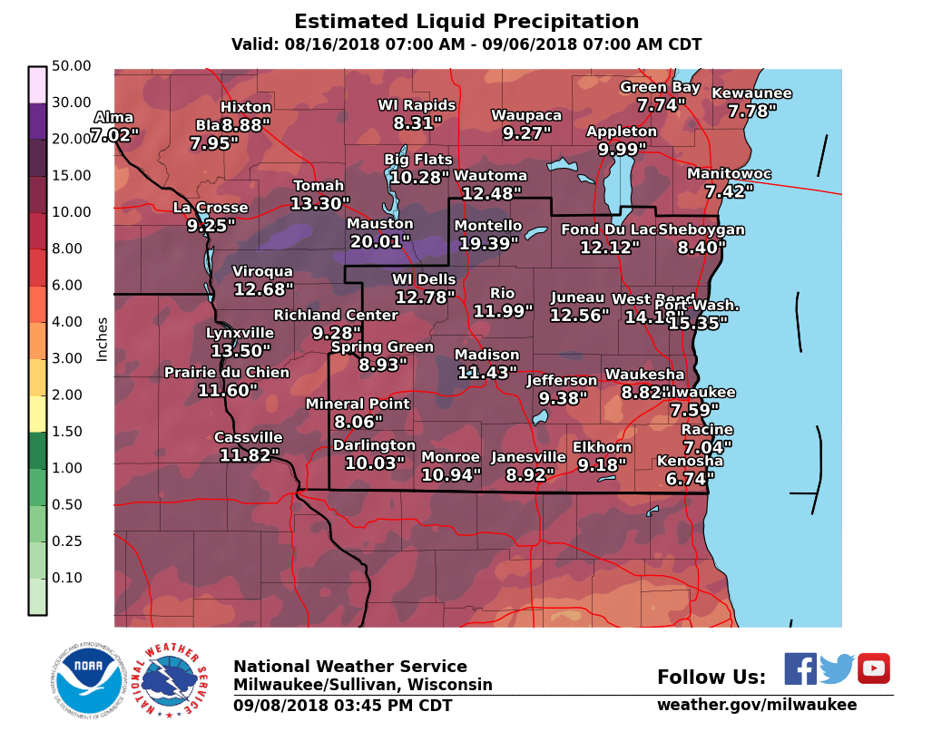
Biggest thing here was definitely the August floods and heavy rain. I got about a foot of rain in two weeks around here. Some areas like the west side of Madison got 15 and a corridor south of Mauston got over 20 inches.
During that whole stretch on the 28th there was also a pretty prolific QLCS-fest of tornadoes. There was a total of 19 tornadoes with the strongest being an EF-2 just to the north of Brownsville. https://www.weather.gov/mkx/aug2818.
The other major event of the year was probably the April 13th-15th storm. That one would've been a big storm in February but in APRIL? We got like 6 inches of snow with some downright blizzard conditions at some points. It was also ironically the first WSW of the year for me. At least we didn't get the 30 inches that Green Bay saw. Other than those 3 major events there really wasn't anything major.
Pretty accurate summary for southern WI. Seems the only impact wx we get anymore is excessive rain & associated flooding, which isn't photogenic/adrenaline-pumping like severe or photogenic like winter. It's just disruptive, destructive and dangerous.
Snow in April sucks *** especially when we can't buy it in December, and although the 8/28 severe event was moderately significant, it was not chaseable being both a wrapped up QLCS and occurred in the trees (although not the "northwoods," Adams, Juneau, Marquette and Green Lake counties have a lot of territory covered by tall, dense pine forests).
-
1
-
-
2018 in severe weather, with the exception of just a couple days, in a nutshell right here in the Day 4-8:
QuoteIt seems the evolution of the mid-level trough will favor a scenario in which the surface cyclone and strongest low-level mass response will be somewhat displaced from richer low-level moisture.
-
2
-
 1
1
-
-
55 minutes ago, Jonger said:
This is 2011-2012 reincarnated.
Strange given we are in a Nino wheras then we were going from Nina to Nina.
-
Just a very narrow/weak ribbon of CAPE depicted ahead of the front and wrapping back into the triple point (on the 12Z, too). Need systems like that in A/M/J 2019 after a couple weeks of Gulf priming. Still will monitor, if the last couple years have taught me anything it's to not sleep on out of season chase opportunities in N. IL.
Still, that system as currently depicted verbatim is representative of the S. WI weather hole of the last several years. Severe misses to the south, big snow misses to the north (or, as in the case of the late November system, snow missed to the south, too).
-
1
-
-
Anyone think there is anything to the Day 4 highlight or is it just SPC being bored and trying to give themselves something to do?
-
11 hours ago, Hoosier said:
Big bertha brings in the new year if the GFS is right.

Nice shaft job for the western Lakes there...
-
If SSW is going to happen I hope it hurries up and does so soon so its effects (including a quashed chase season) don't linger into next May like they did this past spring.
-
We finally broke into sunshine around midday today...and all of the ice from the freezing fog earlier in the week has finally fallen off the broadcast tower at work. Didn't need my heavy jacket when I took the trash out earlier, either.
-
48 minutes ago, hlcater said:
It might just be me, but there seem to be quite a few similarities from where we are now to the winter of 14-15. Especially in the Pacific.
Well, that wouldn't be SO bad...2015 had Rochelle (THIS time I'll know to be patient with the N. IL WF, lol) and a moderately busy May for the Plains, although a lot of the events featured rain-wrapped tornadoes or underperformed their ceilings (looking at you, May 16) but at least there was a decent sequence of chase-worthy days, followed by (partial) N. IL redemption for me on June 22nd as I did get on a tornadic supercell, but the tornado was wrapped in rain from my vantage point and was nowhere near as spectacular as what had occurred in that area 10 weeks prior.
I keep getting the winter of '14-'15 confused with that of '15-'16...the only thing that really stands out to me about the former is the very cold February. In '15-'16 I remember we got an early season blast of snow in November (more than what we got this year) followed by a thaw right around Thanksgiving leading into a quite mild December (what James Spann called the "El Nino Blowtorch") with the MS/TX violent tornado events around Christmas.-
1
-
-
1 minute ago, hlcater said:
You can bet its back

F...
-
11 minutes ago, hlcater said:
The blob says no.
I thought it died in 2016...
-
Last year we didn't see a flake until Christmas Eve, so we're already ahead of that although it has still been an awful lot of early cold with little precipitation. Last winter it turned brutally cold on Christmas and stayed that way for most of January with hardly any precipitation. We squeezed out a few minor snow events in early February but got most of our totals in March and April, go figure.
At this point I really don't care what winter does, as long as it finds a way to lead into a considerably more active severe/chase season than the last couple. -
Well we got a quick hit of what I would call a "generous dusting" up to about 1/2" of mood flakes this morning. Better than the bare tundra of the last couple weeks.
The annoying thing is, we got whiffed to the south by the November crusher, yet you go about 30-45 minutes north around Portage, Wis. Dells, Mauston etc. and there's solid snow cover. Made for a nice effect with the lights of the CP Holiday Train when I chased it last Saturday.
-
2
-
-
2 hours ago, fluoronium said:
This year it felt like both spring and fall were skipped here and the seasons seemed to transition directly from winter to summer to winter. I did a calculation for Peoria, IL to see how the daily temps this year compared to normal. My criteria for spring/fall like weather was highs in the 60s and 70s. The "average" number of days with highs 60F to 79.9F is 109 per year. That is, the daily average high temp is in that range from April 8 to June 6 and from September 9 to October 27. This year there were only 65 days in that range, or 59.6% of normal. I can't say I am a fan of skipping the transition seasons.
Precisely. That lack of transition seasons (and consequent lack of severe weather, until last Saturday) is my main gripe with 2018 (and actually, most of this decade). If this is what climate change looks like, maybe I need to find some new hobbies.
-
1
-
-
I haven't seen it specifically mentioned in this thread yet - the Taylorville tornado has been bumped up to EF3 with a 12.7-mile path. Nothing to sneeze at in any season!
QuoteTornado #7 - Taylorville
CHRISTIAN COUNTYDate 12/1/2018 Time (Local) 5:01 pm - 5:25 CST EF Rating EF-3 Est. Peak Winds 155 mph Path Length 12.7 miles Max Width 1/2 mile Injuries/Deaths 22/0 Summary:
Information from emergency management indicated 34 homes severely damaged/destroyed, 66 homes with major damage, and 406 homes damaged but inhabitable.
NWS EF-Scale ratings in the southside of Taylorville were EF-3 with estimated wind at 155 mph with a maximum width of 1/2 mile.


December 31-January 1, 2019 Storm
in Lakes/Ohio Valley
Posted
Ten minutes after previous pic: