

CheeselandSkies
-
Posts
3,248 -
Joined
-
Last visited
Content Type
Profiles
Blogs
Forums
American Weather
Media Demo
Store
Gallery
Posts posted by CheeselandSkies
-
-
4 hours ago, SchaumburgStormer said:
Like any panic, we have a major disconnect between the facts and the perception.
Facts are, this is a serious disease and we should start taking precautions. They may seem a bit extreme at this point, but we do not have a good handle on what we are dealing with. Err a bit on the side of caution. 99.99% of the public would be much better off by simply WASHING THEIR F'ING HANDS than hoarding toilet paper or any other commodity.
These steps are not being taken to protect healthy young people from the disease. They (myself included) will get it, probably think its a cold or allergies, and will move on. However, the precautions are in place so that I don't pass this to my grandmother, or my immuno-compromised brother, or the person who is mid-way through a chemo treatment, of the little child with an underlying congenital disease.
I keep hearing "I will be pissed if we cancelled everything and no one even gets sick." This may be the stupidest view I have seen, as THAT IS THE ENTIRE POINT.
Bottom line, people need to stop panicking. This isn't Ebola or some sort of air transferred AIDS. Instead of buying our local store out of toilet paper, maybe reschedule that birthday party. Maybe postpone that business trip. Stay home from work if you feel ill. Lets be prudent and take some precautions to protect the most vulnerable in our population. It could be your mother, grandmother, sister, or neighbor that may be helped.
Quite likely the most reasonable post I've seen on this subject on any of the weather forums I'm on. Thank you.
-
 1
1
-
-
4 hours ago, andyhb said:
Why do you keep tagging me with the weenie emoji?
Because it's a severe event to weenie out over.

-
1 hour ago, andyhb said:
Definitely a few similarities with the setup that yielded the deadly TN tornadoes on 3/3. Strong westerly flow aloft with similar hodograph structure and I'm going to bet that the NAM/NAM 3 km are too cold at the surface. Any southerly component to the surface wind will yield large 0-1 km SRH when your 850 mb jet is 50 kts out of the WSW.
18Z HRRR sim ref/UH looks ugly for MO bootheel/southern IL/KY tomorrow, but we saw that have a tendency to overhype particularly with some of the OK setups last May. Of course, tomorrow will feature a rather different set of conditions than those did.
-
Interesting, usually CPC follows SPC's Day 4-8 in that outlook. Rarely seen them introduce a severe area on their own since the Day 4-8 became a thing (or do so beyond 8 days).
-
2
-
-
Ugly in the sense of favorable for svr wx?
-
9 hours ago, frostfern said:
Yea. Tornado outbreaks in March and April are usually going to coincide with abnormal warmth and humidity for the time of year. That doesn't mean you need summer-like temperatures though. Shear is far more important, and low cloud bases / high relative humidity is very beneficial because evaporative cooling from nearby precip won't completely stabilize surface-based storm-inflow.
I think Dr. Leigh Orf's work provided some pretty strong evidence that violent tornadoes ingest a lot of surface-based parcels that are more stable than average, yet still realize some positive buoyancy once lifted into the middle levels of the storm by the upward vacuum-suction force of the rotating meso. Hot weather brings you the highest surface based CAPE, but that CAPE can be completely neutralized by just a little bit of precip if the boundary layer is characterized by low relative humidity. The result is many hot-day summer supercells have elevated inflow, and thus never produce tornadoes. Early spring supercells are very good at producing tornadoes because they often form in an environment where instability is more than adequate for strong convection despite high boundary layer relative humidity.
Good insight, I need to get better about remembering this. Being based further north (like you) I've seen many an early season (even well into May for us) potential setup get quashed by insufficient instability, so I'm a CAPE guy. I get really geeked out to chase on those 86/77 days, then wonder why the updrafts weren't going up like atom bombs. This mindset cost me on 4/9/2015, when I was bumming around IN OGLE COUNTY, IL until about 4:30 PM, then threw in the towel and started for home. Got there just in time to pull up GR Level 3 and see the debris ball about 10 miles from where I'd just been 90 minutes before.
-
33 minutes ago, nrgjeff said:
...CAMs actually had robust storms, but not necessarily a boundary rider beast. Old fashioned meteorology could have provided a more obvious heads up before the evening news. However, credit some local TV Mets for sounding the alarm on the evening news. Still, it's tough to overcome a 1am long-track cyclical damaging tornado...
Good to hear this. Any YouTube uploads of this "pregame" coverage? It seems to me far too often most local TV mets (**coughcough the ones in my local market**) just parrot what the models are spitting out/what the NWS says, are reluctant to do their own mesoscale forecasting; go out on a limb and either downplay an event that everybody else is hyping (would have served them well in most of the snow events this past winter) or sound the alarm about what had seemed like a low-key situation (like overnight Monday-Tuesday). It's high reward, get it right and you look like a genius and earn major credibility for your station over the competition, but also high risk if you get it wrong.
-
1
-
-
Came out of work at noon to a clear blue sky, a touch of warmth from the midday sun, and the sirens blowing for the first-Wednesday-of-the-month test. A little eerie after what just happened in Tennessee, but nice.
-
9 hours ago, cyclone77 said:
Looking like the first 10-12 days of March will be quiet. Euro has 70s into the west half of Iowa next Monday.
Anomalous early season warmth this far north without the threat of
 ...meh.
-
44 minutes ago, snowcaine said:
6" seems like a reasonable call for Toronto at this point, I'll take it.
Slightly OT but it always used to weird me out when Toronto posters would talk about getting rainers. I always thought of Canada as this place way far to the north that's inevitably colder and snowier than us. I have to remember Toronto is only a few degrees of latitude north of me.
-
1
-
-
2 hours ago, cyclone77 said:
Guess the GFS was a little off with this.
When Madison was riding the southern cutoff but still got over 10." What could go wrong?
-
What would be excellent is if we could still manage to get a BS SSW in mid march like I mentioned at the beginning of this thread to ensure maximum suffering.
If that happens and kills the tornado season just like in 2018, 100% chance I lose all interest in weather. Been nice knowing y'all.
Sent from my SM-G955U using Tapatalk
-
12 minutes ago, Chicago Storm said:
18z Euro...

After that suite with a near unanimous agreement on 10"+ for Madison...

-
 1
1
-
 1
1
-
-
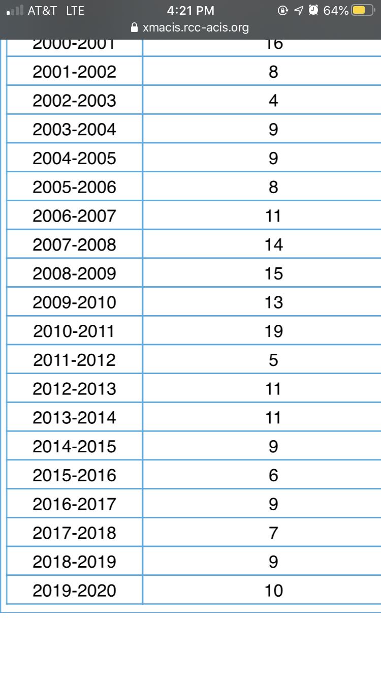
15 hours ago, madwx said:
Here’s the max depth of the past 13 or so winters. Can really see the hot streak we had from 2007-2011
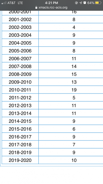
See, and here I thought that period was just us getting back to proper Wisconsin winters.
-
1
-
-
Been a long long time since there was a proper regional outbreak. I think you have to go back to Palm Sunday 1965 for one that affected IA, WI, IL, MI, IN and OH.
-
47 minutes ago, Luftfeuchtigkeit said:
I just got back from running errands - despite the mid-February sun angle and midday timing, it's coming down hard enough to accumulate pretty well out there. I measured 2.3" when I got back home.
What part of town are you in? I'm far west side near Mineral Point & the Beltline. @madwx, what are you seeing?
-
1
-
-
55 minutes ago, Luftfeuchtigkeit said:
It started with light snow around 9am, but now we're getting big wet flakes. Probably already half an inch down. I was expecting very little with this storm because of the northerly track and mixing with rain, but if it keeps this up very long we're going to get more than expected.
I was just thinking to myself looking at radar and out the windows at work that this has the look of an overachiever. Go figure, since totals with this event were not expected to be that impressive to begin with. Why can't we ever get an anticipated big dog that verifies at or above even the high end of guidance?
-
2 hours ago, Geoboy645 said:
-15 here. I am not surprised at all by Black River Falls being -33, they are always like the coldest spot in the area. Them and Lone Rock.
When I was a kid growing up in Madison (early '90s), our TWC local forecasts would always show current conditions at Madison, as you'd expect. However, when I visited my paternal grandparents in Beloit, their local forecasts always began with "Conditions at Lone Rock." This struck me as odd even then, even more so when I realized Lone Rock isn't anywhere near Beloit.
-
1 hour ago, michsnowfreak said:
My personal favorite is when there is NOT agreement a few days out and the model camps then swap ideas. For example, 4 days out the American models will be north and strong and the foreign models south and weak, then 2 days out the American models will be south and weak and the foreign models will be north and strong.
Seen that happen not just with winter but with potential severe outbreaks and TC track/intensity...craziness.
-
1
-
-
3 hours ago, Baum said:
huh?
You have to adjust for the Chris Broyles hype factor in any convective outlook he does. He has a history of being enthusiastically over-bullish on severe/tornado potential (he tends to forecast for the worst-case scenario within the model spread, instead of a blend/the most probable).
-
 1
1
-
-
After hemming and hawing for several days due to model variability...SPC went ahead and dropped a big old Day 4 30% for Dixie Alley...and it wasn't Broyles!
-
9 hours ago, Malacka11 said:
Pretty good hit for Chicagoland on the 12z Euro. Please, whoever makes the storm thread, don't jinx it.
Already a notable shift south from the previous 0Z run which had a big dog for S. WI.
I'm in the "I'll believe it when I see it" camp at this point.
-
1
-
-
47 minutes ago, madwx said:
still looking solid for 3-6" here. Only the NAM is not playing ball and even that is trending upwards. 12z Canadian shows the heaviest band heading into N Illinois. Gives Cyclone and Hawkeye a good hit
4.6" would be right up there for us this winter.
-
2 minutes ago, King James said:
A thunderstorm at this point would be heaven. Hanging out in the mid 30s with clouds all winter is pretty boring.I know, right?
-
1
-
Tn Valley Severe Weather
in Tennessee Valley
Posted
CPC has had this in their hazards outlook for a few days now. SPC Day 4-8 hints at it in their wording but they're still reluctant to commit to delineating a risk area.