CheeselandSkies
-
Posts
3,361 -
Joined
-
Last visited
Content Type
Profiles
Blogs
Forums
American Weather
Media Demo
Store
Gallery
Everything posted by CheeselandSkies
-

Nov 28-30th Post Turkey Day Winter Storm
CheeselandSkies replied to Chicago Storm's topic in Lakes/Ohio Valley
I think you have to go all the way back to 2009 for the last true big dog (double digit totals) prior to December 10th in my memory. That one surely had some compaction involved, because it was low-ratio library paste, yet still flirted with or exceeded a foot in most parts of southern Wisconsin. -
Nov 28-30th Post Turkey Day Winter Storm
CheeselandSkies replied to Chicago Storm's topic in Lakes/Ohio Valley
Looks like Madison is actually riding the north edge of the double digit totals. NAM has gradually come down a bit, from 12.8" to about 10.8" However points in far southern Wisconsin such as Janesville still get in on 12-13." -
Didn't see this thread until almost a year later, but I gave you a follow.
-
Nov 28-30th Post Turkey Day Winter Storm
CheeselandSkies replied to Chicago Storm's topic in Lakes/Ohio Valley
Mainly I'm annoyed that because of the way the trough has evolved vs. the GFS and Euro from 3 days ago, there's no outbreak threat anywhere, not even the Lower MS Valley/Dixie, to armchair chase while getting snowed in. Some of the runs were showing upper-50s dews with solid vertical depth getting pulled as far north as northern KS on Sunday or Monday, in the presence of classic meathook hodographs. -
Winter 2025-26 Medium/Long Range Discussion
CheeselandSkies replied to michsnowfreak's topic in Lakes/Ohio Valley
I've noticed as of today the models have it amplifying more in the central CONUS rather than the western. This puts a kibosh on potential but it still brings the snow this weekend, at least for me and points north. -
Nov 28-30th Post Turkey Day Winter Storm
CheeselandSkies replied to Chicago Storm's topic in Lakes/Ohio Valley
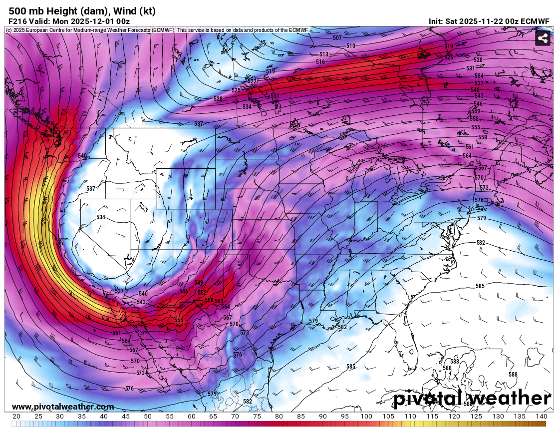
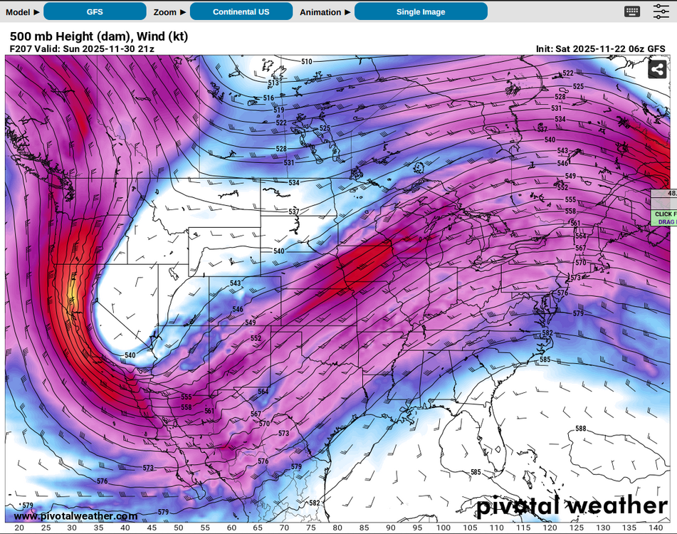
12Z GFS rolling... -
So what *is* good? And has NWP really regressed that badly in recent years or it is just perception (which I share)? If the former, why?
-
Fall 2025 Medium/Long Range Discussion
CheeselandSkies replied to Chicago Storm's topic in Lakes/Ohio Valley
Long as that doesn't mean winter hangs around till the end of April the following year like it did then. -
Euro and GFS both have a broad, highly amplified western trough for the end of the month. Far too early for specifics especially lately, other than to say it "should do something somewhere," from to to . Ceiling might be limited by a tendency for a positively tilted ejection with the stronger flow hanging on the back side, and of course thermodynamics this time of year. Although after days like February 8, 2024 I never count out tornado threats based solely on T/Td values, it looks like this setup would need colder temperatures aloft than what's currently being depicted verbatim to realize adequate instability.

-
The one in my Corolla has been stuck on for over a year. I check the tires with a pressure gauge periodically and they are always close to spec, if one is low I pump it up but the light never turns off.
-
2025 Atlantic Hurricane Season
CheeselandSkies replied to BarryStantonGBP's topic in Tropical Headquarters
At one point it looked like there was a chance Hurricane Leslie of 2018 might shoot the Straight of Gibraltar and become a "medicane," which would have been a fitting conclusion given that system's prior history. -
Nothing here this morning, unless I slept through it.
-
20 years ago OTD. Copy/pasted from my YouTube description: On August 18th, 2005, Wisconsin experienced what still stands as its record single-day tornado outbreak, with 27 occurring in the state. The most significant of these was a high-end F3 which tracked for 20 miles through residential subdivisions on the northern edge of the city of Stoughton, in southeastern Dane County. The house where my parents and I lived at the time (and they still do) is in one of these subdivisions. The tornado missed us by less than 1/4 of a mile, and the one man who died in it (I believe still the last tornado-related fatality in southern Wisconsin to date) lived on the opposite end of the same subdivision. I was 19 at the time and about to start my sophomore year in college. I had long had a fascination with severe weather and tornadoes from childhood and intended to take up storm chasing at some point. For a long time I was angry at myself for not being more prepared on this day and ready to get better footage (a quick YouTube search will unveil the many incredible videos which exist of this tornado, captured by several people who lived not far away). I felt like the atmosphere had tried to hand me the ultimate "backyard chase" and I botched it. You never actually see the tornado itself, just debris falling out of the sky beneath violently churning clouds over our house before I ran for cover (portions of the audio muted because I was shouting like an idiot), and then the structure on the back edge of the supercell thunderstorm after it had moved off and was producing a series of weaker tornadoes north of Lake Koshkonong/west of Fort Atkinson. Most of this footage has never been shared before on YouTube. I had the damage tour section on my old channel, uploaded about a year and a half after the fact in YT's old, lousy 240p resolution, but that was about it. Attachment space limits are too tight here, but damage photos are on TW for anyone else who's a member of both: https://talkweather.com/threads/tornado-anniversaries.2250/page-11
-
2025 Short Range Severe Weather Discussion
CheeselandSkies replied to Chicago Storm's topic in Lakes/Ohio Valley
SPC already trimmed the slight out of southwestern WI behind the ongoing band, so looks like they expect primary severe threat to be with that and not any redevelopment later this afternoon. -
2025 Short Range Severe Weather Discussion
CheeselandSkies replied to Chicago Storm's topic in Lakes/Ohio Valley
13Z slight risk upgrade with the addition of a 2% tornado contour is giving me deja vu on this 20th anniversary. Overcast here in Madison, and the additional rain pushing in from Iowa doesn't lend confidence in clearing anytime soon, but satellite does show clearing in northern IL and nosing into far southern WI. That line in Iowa looks to be flying though so we may yet clear out around midday. Will have to see where the outflow and differential heating boundaries end up. -
Those CAMs are insistent on killing off the would-be Round 1 for us, the cluster currently pushing east through northeastern Iowa, as it crosses the MS later this afternoon/early evening, but it seems to have already persisted longer than those depictions.
-
12Z HRRR and 3K NAM could hardly be more different with the timing and placement of convection over WI over the next 48 hours.
-
Looks like we might be in for another round of hydrologic issues at some point this coming weekend. 0Z 3K NAM is suggesting Saturday night for the most widespread/long duration convection but that is still pretty far out in its range. @madwx
-
5 years ago OTD. Looked a lot like being in a car wash. @hawkeye_wx Probably still a notable lack of trees, right?
-
CAMs (18Z 3K NAM/0Z HRRR) aren't too enthused about much more than garden variety tomorrow. EHI is pretty low. SPC may have been over-optimistic expanding the slight risk into all of S. WI and adding a 2% tornado contour. Edit: 0Z 3K NAM is quite a bit more aggressive than the previous couple of runs. Hard to pin anything down with such lack of agreement/consistency.
-
The jet energy has been there, but it always stays hung up in the Dakotas/MN and never moves east.
-
...annnnnnd it's gone (today's marginal at least, they probably took it away because the HRRR support went away).
-
As hoped, the atmosphere took my post as a challenge. Marginal risk today, slight just northwest of me Saturday. Not looking like anything huge, but better than it was looking just 24 hours ago.
-
What a week ago on the GFS looked like it might finally be a sustained, active severe weather pattern for us this coming weekend into early next week now looks to once again focus well west of the Mississippi River and stay there until it fizzles out.
-
2025-2026 ENSO
CheeselandSkies replied to 40/70 Benchmark's topic in Weather Forecasting and Discussion
Did we not have an extended period of +PDO in the early-mid 2010s? I recall the slower tornado seasons of those years (mainly 2012-2015, notwithstanding events like Rozel, Moore, Pilger, Rochelle) being attributed to that.