CheeselandSkies
-
Posts
3,358 -
Joined
-
Last visited
Content Type
Profiles
Blogs
Forums
American Weather
Media Demo
Store
Gallery
Everything posted by CheeselandSkies
-
As long as it doesn't last for 8 weeks straight.
-
That wasp @A-L-E-K photographed better have skedaddled back to its hibernation hidey-hole.
-

Winter 2025-26 Medium/Long Range Discussion
CheeselandSkies replied to michsnowfreak's topic in Lakes/Ohio Valley
*Looks at 18Z GFS and cries* I HATE prolonged deep cold. Looks like those flagging the 2013-'14 similarities were right. Can only hope unlike that year it breaks in time to not totally bollocks season apart from a 3-day sequence in mid-F*CKING JUNE. -
Winter 2025-26 Short Range Discussion
CheeselandSkies replied to SchaumburgStormer's topic in Lakes/Ohio Valley

-
Yeah. I work in local news and based on our mets' forecasts I was not expecting it to snow at all yesterday beyond the early morning.
-
Winter 2025-26 Short Range Discussion
CheeselandSkies replied to SchaumburgStormer's topic in Lakes/Ohio Valley
On top of that, it snowed most of the rest of the day yesterday (which was NOT forecast). We actually set a daily record due to the ridiculous ratios. https://www.facebook.com/share/p/1ZDN338aPL/ -
Winter 2025-26 Medium/Long Range Discussion
CheeselandSkies replied to michsnowfreak's topic in Lakes/Ohio Valley
Just like it is in the opposite direction for warm fronts/tornadic supercells, with very rare exceptions. -
Winter 2025-26 Medium/Long Range Discussion
CheeselandSkies replied to michsnowfreak's topic in Lakes/Ohio Valley
I should just go back to using the NCAR model site that was the first one I ever came across, still looks like it did in 2006 and the GFS only goes out to 192 hours. -
Winter 2025-26 Medium/Long Range Discussion
CheeselandSkies replied to michsnowfreak's topic in Lakes/Ohio Valley
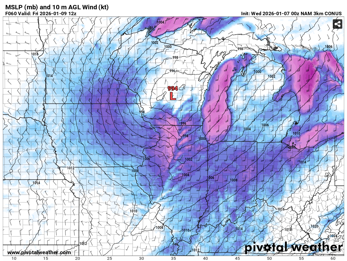
Looks like most of it comes from a wound up storm system that tracks from AR to the NC/SC border from FH246-270. Verbatim would support some severe weather in LA/MS on the 23rd, too. -
On nearly every chase day I've had where I've seen tornadoes, or was within striking distance of tornadoes but missed them due to being dumb, I've seen that sky when approaching/arriving in the target area.
-
Unfortunate waste of potential in both the and departments. Could have done something significant with a little more antecedent cold air to pull in on the back side and different timing/better lapse rates in the warm sector.
-
Yeah, those should definitely be in winter hibernation. Founding queen of Vespula germanica (German yellowjacket).
-
I have Friday off. Why couldn't this system be about 6-7 hours slower?

-
Winter 2025-26 Medium/Long Range Discussion
CheeselandSkies replied to michsnowfreak's topic in Lakes/Ohio Valley
Oh, *bleep*. Hard pass on that look for me. -
Winter 2025-26 Medium/Long Range Discussion
CheeselandSkies replied to michsnowfreak's topic in Lakes/Ohio Valley
Hey, by the last day of March 2023 I was shooting in Iowa so I'll take it. -
Winter 2025-26 Medium/Long Range Discussion
CheeselandSkies replied to michsnowfreak's topic in Lakes/Ohio Valley
Bunch of people rushed out and bought snowblowers for the end of November storm; now won't use them again for 5 years. -
Winter 2025-26 Medium/Long Range Discussion
CheeselandSkies replied to michsnowfreak's topic in Lakes/Ohio Valley
Here's the thing though. May not be true for other parts of the sub, but here in Wisconsin we can be solidly AA in Jan/Feb and it's still cold enough to snow. I'm firmly part of the camp who can do without the extended periods of barely cracking 10°F. -
Winter 2025-26 Medium/Long Range Discussion
CheeselandSkies replied to michsnowfreak's topic in Lakes/Ohio Valley
From wind chills in the -20s today and tomorrow to...that. The phrase "averages are merely a mean of extremes" comes to mind. Between the first and second halves, this month will likely show up as close to "normal" temperature-wise around these parts when all is said and done, but it will say absolutely nothing about the conditions actually experienced on any given day. -
Winter 2025-26 Medium/Long Range Discussion
CheeselandSkies replied to michsnowfreak's topic in Lakes/Ohio Valley
4 years ago OTD...
-
Nov 28-30th Post Turkey Day Winter Storm
CheeselandSkies replied to Chicago Storm's topic in Lakes/Ohio Valley
Cassville, WI live camera: -
Nov 28-30th Post Turkey Day Winter Storm
CheeselandSkies replied to Chicago Storm's topic in Lakes/Ohio Valley
Been steadily snowing all morning in Madison but rates and flake sizes have been fairly run-of-the-mill. Hoping one of those heaver bands can make its way up here. -
Nov 28-30th Post Turkey Day Winter Storm
CheeselandSkies replied to Chicago Storm's topic in Lakes/Ohio Valley
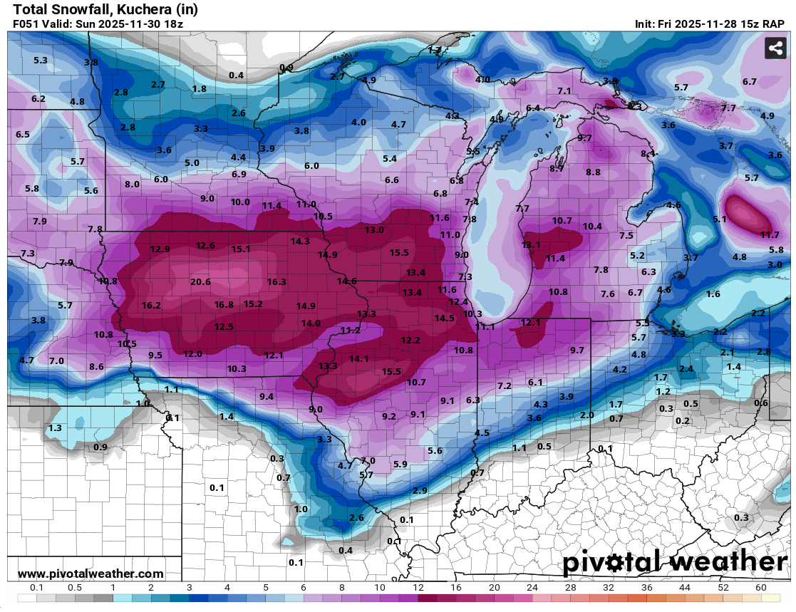
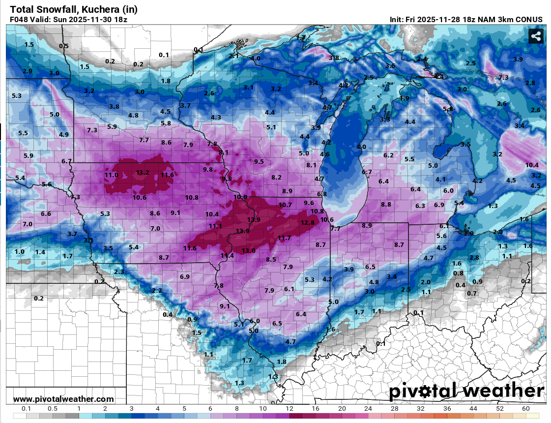
18Z 3K NAM backed off a bit from its prior few runs, down to a "mere" 8.2" for Madison by 18Z (noon CST) Sunday. Even that would be exceptional for before December 1st. However the 15Z RAP was all in on a top-end big dog with 15.5" at the same forecast hour.

-
Nov 28-30th Post Turkey Day Winter Storm
CheeselandSkies replied to Chicago Storm's topic in Lakes/Ohio Valley
I think you have to go all the way back to 2009 for the last true big dog (double digit totals) prior to December 10th in my memory. That one surely had some compaction involved, because it was low-ratio library paste, yet still flirted with or exceeded a foot in most parts of southern Wisconsin. -
Nov 28-30th Post Turkey Day Winter Storm
CheeselandSkies replied to Chicago Storm's topic in Lakes/Ohio Valley
Looks like Madison is actually riding the north edge of the double digit totals. NAM has gradually come down a bit, from 12.8" to about 10.8" However points in far southern Wisconsin such as Janesville still get in on 12-13." -
Didn't see this thread until almost a year later, but I gave you a follow.