

George BM
-
Posts
2,606 -
Joined
-
Last visited
Content Type
Profiles
Blogs
Forums
American Weather
Media Demo
Store
Gallery
Posts posted by George BM
-
-
Quite tasty June Banter can be.
-
Happy Meteorological Summer weenies!
-
 1
1
-
-
This afternoon actually seemed somewhat similar to though obviously nowhere near as widespread (wind gusts only into the 30s mph IMBY
 ) as the June 4, 2008 mid-afternoon event with a CAPE tongue through the region and decent enough 40-50+kt EB shear with storms decently strengthening as they got east of the mountains and into the metro region. Time of the day was similar as well though the June 4, 2008 event had more outages areawide if I remember correctly. The really impressive stuff was obviously more localized with this event.
-
1 minute ago, Eskimo Joe said:
Thanks. Might be some low topped gusty stuff with minimal lightning? Whats shear looking like?
45-55kt effective bulk shear as of 17z across the region.
-
Just now, Kmlwx said:
Yeah the most recent HRRR runs pretty much suck - just isolated activity.
It's also killing off the MCS way too fast.
-
3 minutes ago, frd said:
Wow, never knew that Moderate Risk only averages once every three years. That explains a lot about the frequency of severe weather in our parts.
Yeap. Our last moderate risk was actually a while ago June 13, 2013. (6 years ago)
-
5 minutes ago, high risk said:
absolutely correct that the NAM nest is not being very aggressive for tomorrow, but at the other end of the spectrum, the two ARW Hi-Res Windows have a very robust event for PA/NY and MD/DE (and maybe WV and northern VA too). Both bring convection out of the midwest early Thursday and redevelop it east of the mountains, with some impressive radar signatures. Not saying this will be the outcome, but it could explain some of the more "excited" forecasts.
Latest 12z long-range HRRR has developed storms in WV with storms also dropping towards the MD/PA line by 21z tomorrow.
-
1 hour ago, H2O said:
BWI 102
DCA 100
IAD 99
RIC 101
CHO 100
IMBY 105 with HI of 115 and DP of 85
A temperature of 105F with a dewpoint temp of 85F will give you a @Subtropics heaven and @wxdude64 killing 140F heat index.
-
 1
1
-
-
37 minutes ago, Kmlwx said:
Comical...I picked a sounding in our area from the NAM nest at 22z on Thursday and it has a SARS match from DDC (95052300.DDC) with a 6in hail result. Still a TON of hail results showing up from SARS...interestingly enough - there have been some IAD ones showing up in the matches.
FWIW (not much at this range) the sim reflectivity on the 3km NAM doesn't look all that impressive. I'm half in and half out.FWIW (not much at this range) check out the "decent" squall line(s) on sim reflectivity through the entire region on the 0z wrf suite. Obviously far out at the end of their range though.
-
6 minutes ago, Fozz said:
I've been meaning to share this, but now is a good time. I am about to start a new job in northern Rhode Island, so I will be leaving the area and moving north this weekend. I've really enjoyed posting with all of you here in the mid-Atlantic subforum, and I've learned a lot over the years and have enjoyed several very good storms. I'll occasionally come back to visit, and will try to make it to a get together if you guys organize anything, but New England will soon be my new home. I'll probably still be around in the subforum
")
Congratulations on the new job! Take care of yourself and don't be a stranger here.
-
1
-
-
3 hours ago, losetoa6 said:
Almost June and we might be fighting suppression on this one .


4th of July will be rockin'.
-
2
-
-
BWI: 108F (September 25th)
DCA: 110F (September 25th)
IAD: 109F (September 25th)
RIC: 112F (September 25th)
SBY: 107F (September 25th)
-
 3
3
-
-
...FLASH FLOOD WATCH IN EFFECT FROM THIS EVENING THROUGH SUNDAY
MORNING...

The National Weather Service in Sterling Virginia has issued a

* Flash Flood Watch for portions of Maryland, The District of
  Columbia, Virginia, and West Virginia, including the following
  areas, in Maryland, Anne Arundel, Carroll, Central and
  Southeast Howard, Central and Southeast Montgomery, Charles,
  Frederick MD, Northern Baltimore, Northwest Harford, Northwest
  Howard, Northwest Montgomery, Prince Georges, Southeast
  Harford, and Southern Baltimore. The District of Columbia. In
  Virginia, Arlington/Falls Church/Alexandria, Clarke, Culpeper,
  Eastern Loudoun, Fairfax, Frederick VA, Greene, Madison,
  Northern Fauquier, Northern Virginia Blue Ridge, Page, Prince
  William/Manassas/Manassas Park, Rappahannock, Rockingham,
  Shenandoah, Southern Fauquier, Stafford, Warren, and Western
  Loudoun. In West Virginia, Eastern Pendleton, Hardy,
  Jefferson, and Western Pendleton.

* From this evening through Sunday morning

* Widespread showers will develop this evening along with possible
  thunderstorms and locally heavy rainfall is expected. Average
  rainfall amounts will be between 1 and 3 inches with locally
  higher amounts around 4 inches possible.

* Heavy rainfall in short periods of time may cause creeks and
  streams to rapidly rise out of their banks along with the
  potential for flash flooding in urban areas.

PRECAUTIONARY/PREPAREDNESS ACTIONS...

A Flash Flood Watch means that conditions may develop that lead
to flash flooding. Flash flooding is a very dangerous situation.

You should monitor later forecasts and be prepared to take action
should Flash Flood Warnings be issued.

&&

$$
-
Severe Weather Disco May 3 2019 4:00AM EDT
Today will potentially be the most dangerous severe weather day experienced in the area in decades. The SPC in Norman, OK has issued a high risk for severe weather for a high likelihood of widespread destructive winds with this afternoon and evenings round of storms. Tornadoes will also be likely with both the morning and afternoon rounds of storms with several strong to violent and long-track tornadoes likely, especially with the afternoon/evening round. Very large hail will also be a threat with the afternoon/evening round of storms. On top of all of this there will be a significant flash flood threat, mainly during the morning hours, as storms train over the same areas with torrential rain. Please use extreme caution if you must travel today.
Rain is currently moving into the western parts of the CWA with some embedded supercells, some already tornadic. Low-level shear will increase as we go through the morning and bands of heavy rain and embedded supercells will continue to quickly move through our region from SSW to NNE. Despite no sunshine, dewpoints rising into the middle 70sF will lead to 1100-1600 J/kg mucape rooted near the surface. With effective SRH in excess of 400 m2/s2, EBWD of 65+ kts and a strong low-level jet (70+kts winds at 1km) several tornadoes appear likely with even a couple strong, long-track tornadoes possible. There will also be a fairly significant damaging wind threat with any organized supercells and bowing line segments. The timing for this round of storms will be between 4am and 10am in the western suburbs. 6am and 12pm in the immediate Washington metropolitan region, and 8am and 2pm along the Chesapeake Bay. The other large threat with this morning round of severe weather will be for flash flooding as PW values will reach the 2.2-2.4 inch range allowing for any storms to contain very heavy rainfall rates. Many of these storms may train over the same areas leading to potentially significant flash flooding wherever this occurs. Rainfall totals through the early afternoon across the region will range from 2 to 5 inches with locally higher amounts where storms train over the same areas. For this a Flash Flood Watch is in effect for the entire forecasting area through the evening. The pressure gradient will also become very tight and with a powerful low-level jet overhead wind gusts around 40kts seem to be a good bet even without any aid from convection. Thus, a Wind Advisory is in effect through the morning hours.
After this round of rain and storms move out there will be lull as a powerful mid-level jet associated with a very fast moving and powerful shortwave trough will blast into the region promoting ample sunshine through the afternoon allowing temperatures to rise into the middle 80’s. The pressure gradient will increase through the afternoon ahead of the shortwave. With lower-level wind-fields becoming very strong (Mean surface to 850mb winds of 50-55 kts) with increased low-level mixing, synoptic wind gusts to 50-55kts seem plausible which will lead to tree damage and scattered power outages. As a result, a High Wind Warning has been issued for the entire Metropolitan region through the afternoon. At the same time the very powerful trough and associated cold front will approach from the west. Mid-level temperatures will cool (500mb temps dropping to -15C). With dewpoints in the lower 70sF or so, MLCAPE will rise to a very strongly unstable 3000-4500+ J/kg. With a 120+kt mid-level jet moving over the region effective bulk shear will rise to 100+ kts. This shortwave will provide extreme forcing along the cold front. As a result, an extremely dangerous and fast-moving line of storms will develop along the front west of the mountains and race through our region between 4-5pm in far western areas and 7-8pm along the Chesapeake Bay. With the extreme kinematics in place and increasingly steep low-level lapse rates storm motions could be in excess of 80 kts. That combined with ample effective bulk-shear and effective SRH in excess of 500m2/s2 will allow for LEWPS and embedded supercells capable of producing swaths of life-threatening hurricane-force wind gusts, potentially as high as 90 to 100mph, and several tornadoes, some which may be strong. Supercells will develop ahead of the main line and with them several fast-moving strong to violent and long-track tornadoes appear likely given the impressive low-level shear. With the cooling mid-level temperatures severe hail will also be a threat with very large hail (3”+ in diameter) possible in any supercells.
Once the storm threat finally ends everywhere after 8pm a record breaking cold airmass will sweep into the region with temperatures everywhere dropping into the 30’s by dawn. With dangerously high winds still in place (wind gusts of 55-70mph), wind chills will drop into the teens in most spots.
Forecaster: George BM
-
CAD war tomorrow.
ETA: 68/58 at IAD at 12:00AM EDT May 1, 2019
-
-
One little note. No mesoscale model has the current activity in Eastern Ohio about to move into southwest Pennsylvania. CAPE is modest but still... it might be able to trigger something in the area later even if the current convection dies out. Just a small note.
#Notanexpertopinion
-
It's a very low-key threat and more likely than not won't happen this way but a few mesoscale models try to get some remnant storms into the region tomorrow afternoon before they redevelop into asoutheastward moving storm cluster or two. This, of course, would be the most extreme case though. Just low-key watching it and exactly where the WNW to ESE oriented front sets up.
-
On 2/20/2019 at 11:47 PM, George BM said:
Nov 15, 2018: 2.4" snow/sleet (Updated)
Jan 12-13, 2019: 9.4" snow
Jan 17, 2019: 1.5" fairly wet snow
Jan 29, 2019: 3.0"
Feb 1, 2019: 1.0"
Feb 10, 2019: 0.5"
Feb 20, 2019: 5.1" snow/sleet (mainly snow)
Total (so far): 22.9"
Mar 1, 2019: 0.5" snow/sleet
Mar 8, 2019: 0.6" wet snow
Total (so far): 24.0"
-
20 minutes ago, Hank Scorpio said:
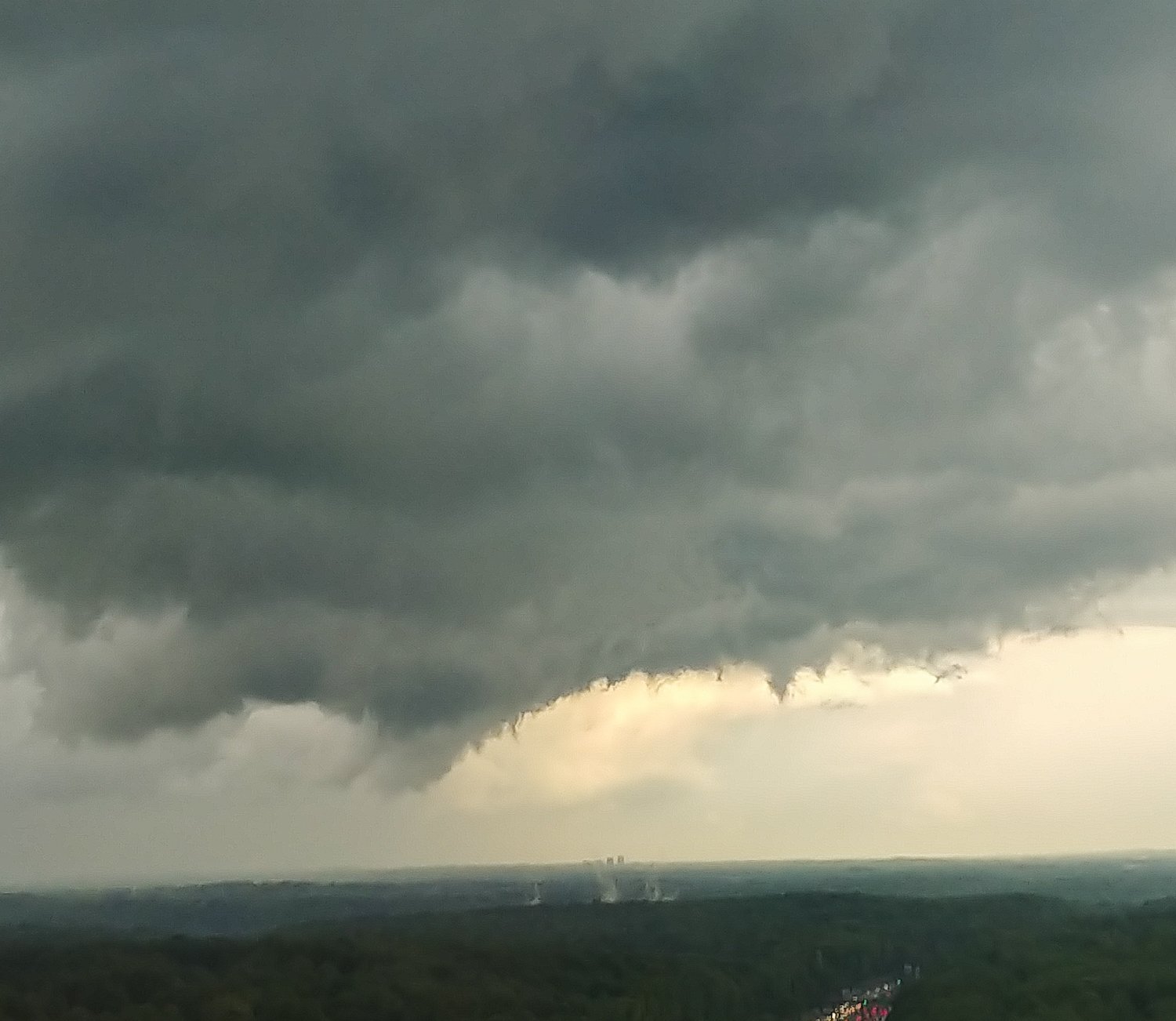
Thanks! Something similar popped up a few times in different places as the whole thing interacted with the Potomac. Here's another occurrence earlier, before it crossed 495:
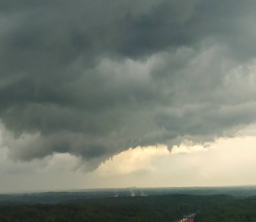
I wonder if you'd find any kind of damage if you went to those locations? Might be very minimal but still. *shrugs*
-
1 hour ago, Jebman said:
Wisc may get a foot of heavy wet snow on Saturday.
Totally and utterly ANNIHILATED!
-
1
-
-
I love how some areas west of I-95 that hadn't been under a Tornado Watch since February 24, 2016 have been under 3 Tornado Watches in 12 days.
-
2
-
-
12 minutes ago, Mrs.J said:
My husbands office is currently under a take shelter proclamation. His office is in Rockville close to Shady Grove Rd. right next to 270.
My Dad's office is close by also in Rockville. He called me about the Tornado Warning.
Mid-Atlantic summer hottest temperature contest
in Mid Atlantic
Posted
UPDATE:
BWI: 111F
DCA: 114F
IAD: 113F
RIC: 115F
SBY: 110F