

George BM
-
Posts
2,603 -
Joined
-
Last visited
Content Type
Profiles
Blogs
Forums
American Weather
Media Demo
Store
Gallery
Posts posted by George BM
-
-
Great time for a power outage that probably has nothing to do with the weather.

-
I'll say this... so far the clouds are SLIGHTLY thinner than they were on Sunday.
-
5 hours ago, yoda said:
Day 1 MOD RISK issued for C VA into SC

Surprised that we aren't at least in some tornado risk atm. I would think that changes later though.
-
5 minutes ago, BTRWx's Thanks Giving said:
Did anybody see today's rocket?
Shoot that was last hour wasn't it. I forgot about it.
-
52 minutes ago, PrinceFrederickWx said:
If there's enough interest, I'm thinking of doing a summer contest- forecast the highest temperature recorded at the usual four airports (BWI, DCA, IAD, RIC) with a tiebreaker being to forecast the highest temperature from one of the following: Charlottesville (CHO), Hagerstown (HGR) or Salisbury (SBY). Let me know your thoughts!
BWI: 106F
DCA: 108F
IAD: 107F
RIC: 110F
SBY: 105F
-
Poor Yoda banished from sleep...
...It appears KIAD gusted to 42kts (48mph) with the line that just came through.
-
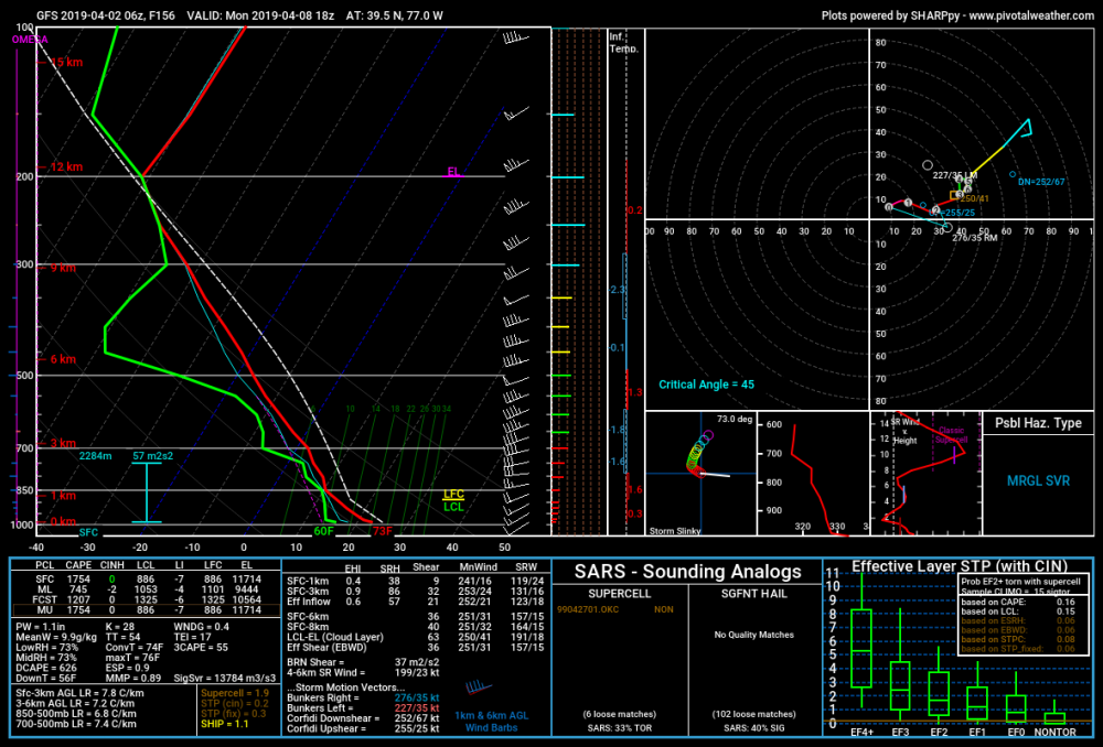
June 21 2019 Severe Disco 4:12PM EDT
Warm front continues to slowly lift through the region to the NNE in a WNW to ESE axis ahead of an impulse of energy approaching from the west. Along and in the vicinity of this warm front surface dewpoints have risen to around 80F w/ temps into the low 90’sF. Surface winds have also backed to ESE in the vicinity of the warm front. Any remaining CIN is just about gone and a few storm cells are starting to pop up over I-81 near Winchester, VA and Martinsburg, WV. With the extreme instability in place (4500-6500 J/kg mlcape), very strong effective bulk shear (55-65+kts), and strong low-level directional shear (effective SRH 250-450 m2/s2) with low LCLs, these storms and any other storms that pop up may become intense supercells capable of producing tornadoes. Some of these many produce strong and long-track tornadoes as they move east-southeast across the region especially between 5-10pm. These storms will also be capable of dropping very large to giant hail (perhaps 4”+ in diameter) and destructive, perhaps hurricane force winds. Some mesoscale guidance develop a severe MCS behind the initial supercells with the main impulse of energy riding along this frontal boundary. Should a MCS develop a more substantial widespread wind threat with some particularly significant wind gusts may evolve with severe hail and QLCS tornadoes. Bottom line is that this afternoon and evening will be a very dangerous one for severe weather in the Greater Washington Metropolitan area.
At this time, tomorrows severe threat seems mainly focused towards the Maryland/Pennsylvania line and the Baltimore region.
Forecaster: George BM
-
3 minutes ago, Kmlwx said:
The only times it is acceptable for dews to be above 60 is when it will bring a severe risk. #ChangeMyMind
The setup doesn't look super robust but at least it's something to track.
Or good tropical
") .
.
-
2 hours ago, Kmlwx said:
The old GFS has some severe risk maybe next week.
Northwest of Baltimore Monday afternoon.
#Digitalsevere
#Soon.
-
A @wxdude64TM day.
-
 2
2
-
-
Tornadoes inbound.
-
1
-
-
Ascending temperatures. Ascending flowers. Ascending grass. Ascending humidity.
-
 1
1
-
-
Severe Thunderstorm Warning MDC031-VAC059-107-600-222015- /O.NEW.KLWX.SV.W.0002.190322T1926Z-190322T2015Z/ BULLETIN - IMMEDIATE BROADCAST REQUESTED Severe Thunderstorm Warning National Weather Service Baltimore MD/Washington DC 326 PM EDT FRI MAR 22 2019 The National Weather Service in Sterling Virginia has issued a * Severe Thunderstorm Warning for... Central Montgomery County in central Maryland... Loudoun County in northern Virginia... The City of Fairfax in northern Virginia... Fairfax County in northern Virginia... * Until 415 PM EDT. * At 326 PM EDT, severe thunderstorms were located along a line extending from near Point Of Rocks to near Bluemont, moving east at 55 mph. HAZARD...60 mph wind gusts. SOURCE...Radar indicated. IMPACT...Damaging winds will cause some trees and large branches to fall. This could injure those outdoors, as well as damage homes and vehicles. Roadways may become blocked by downed trees. Localized power outages are possible. Unsecured light objects may become projectiles. * Locations impacted include... Germantown, Centreville, Rockville, Bethesda, Gaithersburg, Reston, Leesburg, Olney, South Riding, Herndon, Fairfax, Vienna, Broadlands, Lansdowne, Lowes Island, Brambleton, Mantua, Pimmit Hills, Poolesville and Mclean. PRECAUTIONARY/PREPAREDNESS ACTIONS... Get indoors to protect yourself from wind and lightning. Trees around you may be downed from damaging winds, so if you are near large trees, move to an interior room on the lowest floor. Don`t drive underneath trees or in wooded areas until the threat has passed. && LAT...LON 3931 7757 3926 7754 3925 7749 3922 7746 3924 7742 3910 7697 3897 7707 3889 7721 3882 7723 3871 7732 3872 7736 3871 7737 3879 7744 3880 7748 3889 7755 3893 7762 3902 7795 3909 7786 3931 7773 TIME...MOT...LOC 1926Z 285DEG 47KT 3920 7750 3905 7783 HAIL...<.75IN WIND...60MPH $$ DHOF -
3 minutes ago, EastCoast NPZ said:
2" and counting.
I'm surprised you never changed your profile picture.
-
3 minutes ago, WVclimo said:
Winds kicking up now under the deform. 18 G28 and still pouring.
Last year was the snowiest of my 56 birthdays, and today is the wettest.
Happy Birthday WVclimo! We need it to be your birthday more often.....which I know is impossible. I wonder what event we get on this day next year?
-
 1
1
-
-
2.39" at IAD as of 7pm breaking the daily rainfall record for March of 2.30".
-
2
-
-
1.98" through 5pm at IAD today.
Record rainest day in March at IAD is 2.30".
0.32" through midnight should be doable there.
-
3 hours ago, high risk said:
Friday afternoon could be a bit fun as the strong vort approaches. Convective showers are likely, and with very steep lapse rates, it looks like a few folks could see some lightning.
Also looks graupely with,dare I say, some graupely snow mix in with the most intense showers?...... Or is my weenie mode getting carried away again?
-
6 minutes ago, yoda said:
Area Forecast Discussion
National Weather Service Baltimore MD/Washington DC
856 PM EDT Wed Mar 20 2019


.NEAR TERM /UNTIL 6 AM THURSDAY MORNING/...
Clouds continue to gradually lower and thicken tonight ahead of
low pressure developing over the eastern Carolinas. Intermittent
light rain already encroaching on southern Maryland as of early
this evening, and rain is expected to expand quickly northward
while increasing in intensity after midnight (mainly east of
Interstate 81). Some moderately heavy rain is likely by daybreak
between the Blue Ridge and Interstate 95.

&&

.SHORT TERM /6 AM THURSDAY MORNING THROUGH FRIDAY NIGHT/...
There is a decent chance this system will be an "overperformer"
when it comes to precipitation amounts. Strong height falls with
an approaching negatively-tilled mid/upper trough, attendant
mid and upper jet/PVA, and strong low-level moisture flux all
point to an area of moderately heavy rain from Thursday morning
the mid Thursday afternoon across northern Virginia and central
Maryland (mainly between the Blue Ridge and I-95). In addition,
mid-level lapse rates of around 7 C/km will contribute to
embedded convective elements/heavier rainfall rates (possibly
1/2 inch per hour). A few rumbles of thunder are possible as
well given all the strong forcing in place, despite low CAPE
values (less than 200 J/kg).
Now if we just pretend that it's snow and the few rumbles of thunder verify......
-
 1
1
-
-
1 minute ago, wxdude64 said:
About 20 raindrops with zero snow here lol.
I might have gotten 7 drops here.
-
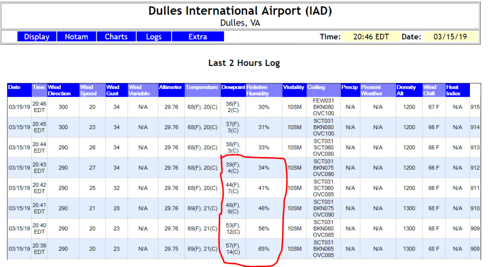
Just a wee bit of a drop in the dewpoint and relative humidity over a four minutes period at IAD this evening.
-
1
-
-
IAD now at 77/58 temp/dewpt at 4:12pm edt on Friday, March 15, 2019
-
5 minutes ago, Kmlwx said:
Well south and east appears to be the site for any action this PM.
I'm wondering whether anything will try to pop up along the front northwest of I-95 looking at recent satellite trends. Not necessarily talking anything too big but perhaps at least some t-showers.
#Notanexpertopinion
-
18 minutes ago, Kmlwx said:
12-24 inches of hail.
I mean Denver can do that in the summer.....
-
1
-


2019 Mid-Atlantic Severe Wx - General Discussion
in Mid Atlantic
Posted
It's time to play Guess the intensity of the Reston area tornado last night.
I'm going with an EF-0: 75mph winds
Guess away! You have until the NWS comes out with the official rating.