

George BM
-
Posts
2,606 -
Joined
-
Last visited
Content Type
Profiles
Blogs
Forums
American Weather
Media Demo
Store
Gallery
Posts posted by George BM
-
-
Flood Watch
National Weather Service Baltimore MD/Washington DC
1123 AM EDT Thu Jul 4 2019

DCZ001-MDZ011-013-014-503>506-VAZ052>054-506-042330-
/O.NEW.KLWX.FF.A.0006.190704T1700Z-190705T0000Z/
/00000.0.ER.000000T0000Z.000000T0000Z.000000T0000Z.OO/
District of Columbia-Southern Baltimore-Prince Georges-
Anne Arundel-Northwest Montgomery-
Central and Southeast Montgomery-Northwest Howard-
Central and Southeast Howard-
Prince William/Manassas/Manassas Park-Fairfax-
Arlington/Falls Church/Alexandria-Eastern Loudoun-
Including the cities of Washington, Baltimore, Bowie,
Suitland-Silver Hill, Clinton, College Park, Greenbelt, Laurel,
Camp Springs, Glen Burnie, Annapolis, Severn, South Gate,
Severna Park, Arnold, Odenton, Germantown, Damascus, Bethesda,
Rockville, Gaithersburg, Silver Spring, Lisbon, Columbia,
Ellicott City, Dale City, Manassas, Woodbridge, Lake Ridge,
Montclair, Reston, Herndon, Annandale, Centreville, Chantilly,
McLean, Franconia, Arlington, Alexandria, Falls Church, Leesburg,
Ashburn, and Sterling
1123 AM EDT Thu Jul 4 2019

...FLASH FLOOD WATCH IN EFFECT UNTIL 8 PM EDT THIS EVENING...

The National Weather Service in Sterling Virginia has issued a

* Flash Flood Watch for portions of Maryland, The District of
  Columbia, and northern Virginia, including the following
  areas, in Maryland, Anne Arundel, Central and Southeast
  Howard, Central and Southeast Montgomery, Northwest Howard,
  Northwest Montgomery, Prince Georges, and Southern Baltimore.
  The District of Columbia. In northern Virginia,
  Arlington/Falls Church/Alexandria, Eastern Loudoun, Fairfax,
  and Prince William/Manassas/Manassas Park.

* Until 8 PM EDT this evening

* Slow moving showers and thunderstorms are expected to develop
  after 1 PM this afternoon before diminishing early this evening.
  Torrential rainfall rates may lead to totals exceeding 2 inches
  in a short period of time. This may cause flash flooding of
  small streams and other poor drainage urban areas.

PRECAUTIONARY/PREPAREDNESS ACTIONS...

A Flash Flood Watch means that conditions may develop that lead
to flash flooding. Flash flooding is a very dangerous situation.

You should monitor later forecasts and be prepared to take action
should Flash Flood Warnings be issued.

&&

$$
-
1 hour ago, North Balti Zen said:
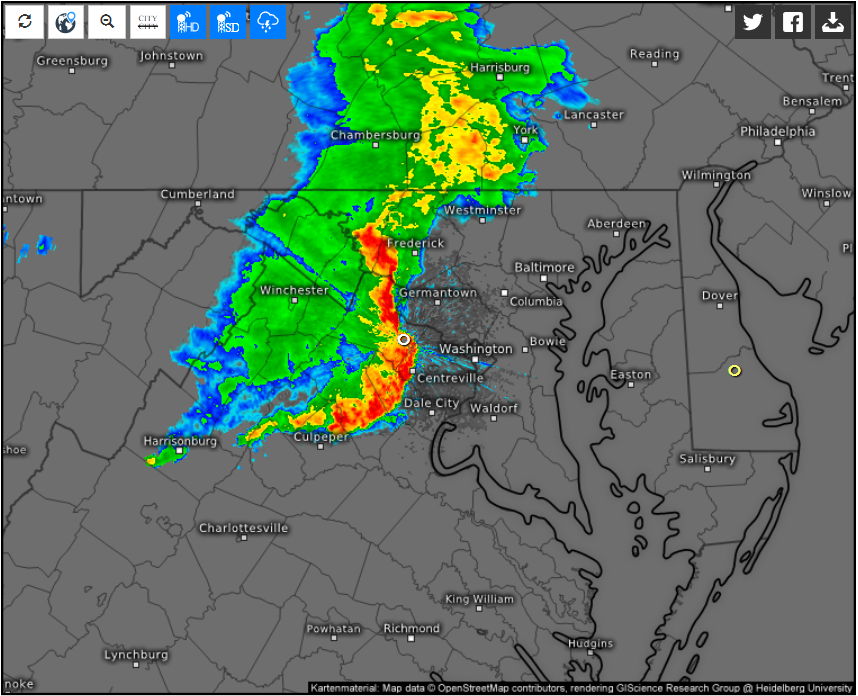
I mean, it was a line, it was absolutely solid, it was on our doorstep, and then...poof.
58 minutes ago, mappy said: couldn't have described it any better, my friend.
My friends my friends welcome to the club!
-
 1
1
-
-
95/69 IAD 5:10pm edt Tuesday, July 2, 2019
-
6 minutes ago, WxWatcher007 said:
I think we'll have our chances.
I can't wait for the annual GFS fantasy cane day where for 4 magical runs we get that major barreling up the Bay.
Yeapers on a bigly reaper stick drenched in weenie tears. It's become a yearly tradition.
-
1
-
-
2 hours ago, losetoa6 said:
Another stellar morning. Got into the 50s again at 59 . Probably the last of the nice overnight lows for a while .
3k and Hrdps have a decent line of convective showers and storms late evening coming due south out of Pa fwiw.
I'm watching the activity in Michigan right now (MCV with some convection) that will drop to the southeast throughout the day. CAPE will be limited early but could rise to over 1,000 J/kg (mlcape that is) especially west of I-95 by mid-late afternoon ( the later it gets the higher CAPE gets). It will be interesting to see whether anything can grow upscale a bit and move in from the northwest later.
-
 1
1
-
-
1 minute ago, yoda said:
As in HX above 100 starting on Wednesday? No thanks
No I meant just tomorrow morning. A beautiful start.
Now if we get HX of 115F+ with 7000+j/kg mlcape and 80+kt deep-layer flow... wait what happened?
Anyway 50's/low 60's tomorrow morning would be beautiful indeed.
-
A beautiful start to a great summer month.
-
Holiday Season approaches.
-
SEL2

   URGENT - IMMEDIATE BROADCAST REQUESTED
   Severe Thunderstorm Watch Number 462
   NWS Storm Prediction Center Norman OK
   205 PM EDT Sat Jun 29 2019

   The NWS Storm Prediction Center has issued a

   * Severe Thunderstorm Watch for portions of
     District Of Columbia
     Delaware
     Maryland
     Northern Virginia
     Eastern West Virginia Panhandle
     Coastal Waters

   * Effective this Saturday afternoon and evening from 205 PM until
     700 PM EDT.

   * Primary threats include...
     Scattered damaging wind gusts to 70 mph possible
     Isolated large hail events to 1.5 inches in diameter possible

   SUMMARY...Cluster of strong thunderstorms over south-central
   Pennsylvania may cross into portions of Maryland and Delaware, while
   additional development occurs farther west. Scattered damaging winds
   are the primary threat.

   The severe thunderstorm watch area is approximately along and 40
   statute miles north and south of a line from 35 miles south of
   Hagerstown MD to 25 miles southeast of Dover DE. For a complete
   depiction of the watch see the associated watch outline update
   (WOUS64 KWNS WOU2).

   PRECAUTIONARY/PREPAREDNESS ACTIONS...

   REMEMBER...A Severe Thunderstorm Watch means conditions are
   favorable for severe thunderstorms in and close to the watch area.
   Persons in these areas should be on the lookout for threatening
   weather conditions and listen for later statements and possible
   warnings. Severe thunderstorms can and occasionally do produce
   tornadoes.

   &&

   OTHER WATCH INFORMATION...CONTINUE...WW 460...WW 461...

   AVIATION...A few severe thunderstorms with hail surface and aloft to
   1.5 inches. Extreme turbulence and surface wind gusts to 60 knots. A
   few cumulonimbi with maximum tops to 500. Mean storm motion vector
   29025.

   ...Grams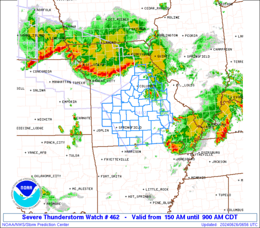
-
1 minute ago, frd said:
Seems severe hail today is a moderate risk.
On the link here
https://www.spc.noaa.gov/products/watch/ww0461.html
Do you know the difference in the table under risks ? The SPC mentions a moderate risk for severe hail, and a low risk for 2 inch plus hail. What defines severe hail ?
Hail 1"+ in diameter (quarter sized or greater)
-
3 minutes ago, frd said:
Storms on the move SE already from NW and Central PA.
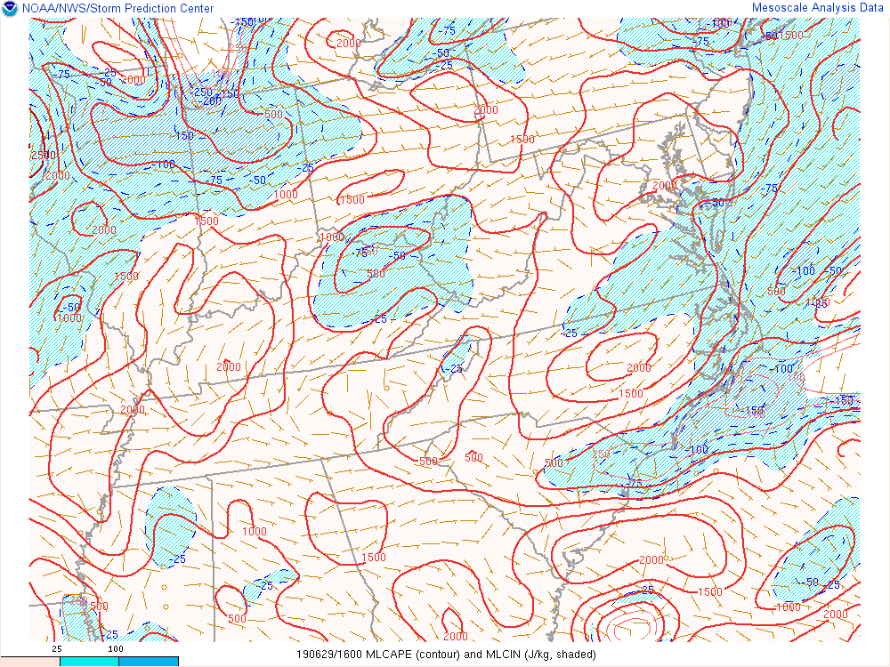
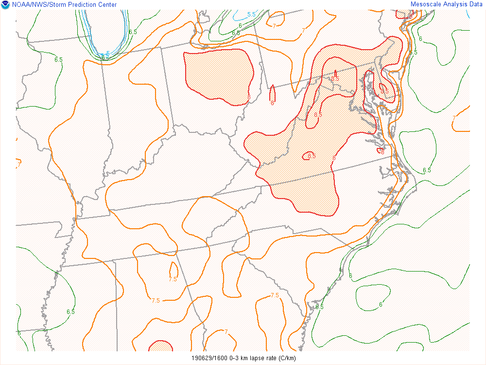
There is some decent mlcape and low-level lapse rates as well as of 16z.
-
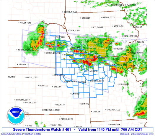
SEL1 URGENT - IMMEDIATE BROADCAST REQUESTED Severe Thunderstorm Watch Number 461 NWS Storm Prediction Center Norman OK 1205 PM EDT Sat Jun 29 2019 The NWS Storm Prediction Center has issued a * Severe Thunderstorm Watch for portions of Far northern Delaware Far northeast Maryland New Jersey South-central New York Central and eastern Pennsylvania Coastal Waters * Effective this Saturday afternoon and evening from 1205 PM until 700 PM EDT. * Primary threats include... Scattered damaging wind gusts to 70 mph likely Isolated large hail events to 1.5 inches in diameter possible SUMMARY...Multiple clusters of thunderstorms will spread east across a large portion of Pennsylvania and adjacent states through early evening. Embedded strong wind gusts producing damage will be the primary hazard. The severe thunderstorm watch area is approximately along and 95 statute miles north and south of a line from 35 miles west northwest of State College PA to 20 miles south southeast of Newark NJ. For a complete depiction of the watch see the associated watch outline update (WOUS64 KWNS WOU1). PRECAUTIONARY/PREPAREDNESS ACTIONS... REMEMBER...A Severe Thunderstorm Watch means conditions are favorable for severe thunderstorms in and close to the watch area. Persons in these areas should be on the lookout for threatening weather conditions and listen for later statements and possible warnings. Severe thunderstorms can and occasionally do produce tornadoes. && OTHER WATCH INFORMATION...CONTINUE...WW 460... AVIATION...A few severe thunderstorms with hail surface and aloft to 1.5 inches. Extreme turbulence and surface wind gusts to 60 knots. A few cumulonimbi with maximum tops to 500. Mean storm motion vector 28025. -
Just now, nw baltimore wx said:
This may not be what you're looking for, but I use this.
That's good, thank you.
-
Just now, MN Transplant said:
It is hot, but it isn't unusual. That said, a long string of 90s can have a cumulative effect on the environment and the psyche. We'll see if we can at least get that break Sun/Mon before we go back to the heat.
91 so far at home. Looks like DCA is 89 or 90 based on the 5 minute obs.
If it won't bother you too much could you post a link to the 5 min obs please?
-
1 hour ago, Kmlwx said:
I don't see much severe risk upcoming.
While it definitely doesn't look like much atm I wouldn't completely sleep on Monday. With increasing cape and modest shear if a remnant MCV moves in from the west it could spark something. Again, it's definitely not much atm but something to watch... perhaps.
-
1 hour ago, Kmlwx said:
At this point I'm all for reshuffling the pattern. Anybody for NW flow/ring of fire pattern? I'm okay with 100 and humid if it produces CAPE of 6000 and a massive line of storms.
Oh hell yeah! Those patterns brings around a lower risk of my yard being in the middle of Splitsville (as well as the negatively tilted trough pattern). It needs to come with deep-layer flow AOA 50KTS as well.
1 hour ago, Kmlwx said:Even a June 4, 2008 would be more than fine. I can think of a bunch of events that would be acceptable.
20080604
20100725
20120629
20130613Ivan too of course.
Give me an 1893 Atlantic Hurricane Season repeat, an October 1878, or a Hazel.
October 15, 1954 was an absolutely marvelous day in the area.
-
Just now, yoda said:
Waiting on the new 00z NAM... but 18z NAM soundings were pretty nice for 21z and 00z tomorrow
Psssst... We abscond the 18z hrdps.
-
1
-
1
-
-
5 minutes ago, high risk said:
Sure, if we can get low 60's dew points back on Thursday, and the front waits until mid-afternoon to move through, we could absolutely get a low-topped line of showers (or even t-storms) with some wind potential. But if we were looking at a more typical June 84/68, it would have been a MDT risk day here for sure.
Random note: This Thursday marks 6 years since the immediate area was last under a moderate risk.
-
3 hours ago, Kmlwx said:
@yoda - Remember though that shear can't be too strong is instability isn't that great as the updrafts could get ripped apart. Plus...NAM at range disclaimer as usual.
If only we could get a Bill 2015 track repeat but with a very powerful southeast ridge in place. An example: Say, a category 1 landfall near Houston, TX Tuesday night, June 18, 2019. Then the fast-flow around the ridge combined with a shortwave moving in from the north slingshots it to this region by Thursday afternoon June 20, 2019 as a ~990mb low bringing backing SSE winds and upper 70's/80F dewpoints and mid 90'sF air temperatures yielding mlcape ~4000J/kg despite warm temperature profiles aloft with 50-60+kt EBWD and 250-350+ m2/s2 effective shear bringing a goodly severe threat to the region.
Sorry. Weenie mode getting carried away. But you hopefully get my drift.
-
29 minutes ago, adelphi_sky said:
I'm ready for HUrricane tracking now. I'm done staring at radar hoping for drops of rain to feed my baby grass. I'll just replant in the fall. Bring on the big storms!
1893 tropical system tracks redux with a Hazel and 1878 track thrown in with mid 30's Celsius water temps off the SE coast and in the Gulf of Mexico please... pretty please with 22 cherries on top.
-
Happy Eleven Year Anniversary weenies!
-
1
-
-
1 minute ago, losetoa6 said:
I do remember a July 4th about 10 years ago that was 68-70 for a high with full sunny skies and everyone brought blankets for the fireworks because it got in the low mid 50s lol.
Sure that wasn't 2014?
-
1 hour ago, Eskimo Joe said:
I'm ready for some +22 air at 925.
Hopefully while occasionally getting into an enhanced 65+kt mid-level "ring of fire" flow. Epic Derecho train FTW!... And then the waters off the southeast coast and in the GOM can rise into the low/mid 30's celsius for peak hurricane season while we get a 1893 repeat in storm tracks.
dot dot dot
68/50 at IAD with 20+mph wind gusts as of 10:37am edt Monday, June 3, 2019
-
23 minutes ago, George BM said:
UPDATE:
BWI: 111F
DCA: 114F
IAD: 113F
RIC: 115F
SBY: 110F
BWI: 101F
DCA: 104F
IAD: 103F
RIC: 105F
SBY: 100F
July Banter 2019
in Mid Atlantic
Posted
Happy Birthday Mr. Reaper!