

George BM
-
Posts
3,032 -
Joined
-
Last visited
Content Type
Profiles
Blogs
Forums
American Weather
Media Demo
Store
Gallery
Everything posted by George BM
-
Three possible years (I don't know for certain. I'm just basing this off of the weather pattern that I remember at those times.) are 2010, 2012 and maybe 2020? Obviously, it also depends on the reporting location.
-
Oh wow. I actually never knew that... nearly 18 years near the airport and you'd think I'd know this. I love learning new things though. 48/46 w/ drizzle at IAD.
-
Yeah. It's all more spread out than before requiring scrolling on mobile (it wasn't like that before). But like you said, they bothered which = it's being used. *Sidenote: Is runway 19 and 01 at Dulles really oriented from 190* to 10*? I always thought it was due north to south. Perhaps just some kind of approximation?
-
2021 Mid-Atlantic Severe Weather - General Discussion
George BM replied to Kmlwx's topic in Mid Atlantic
45% TOR area added now.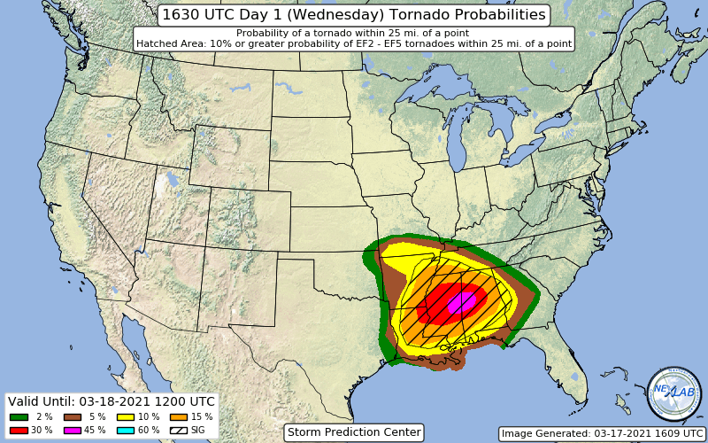
-
Updated http://iadasos.org/IAD/index.html @MN Transplant
-
2021 Mid-Atlantic Severe Weather - General Discussion
George BM replied to Kmlwx's topic in Mid Atlantic
@yoda Ay, where're you at?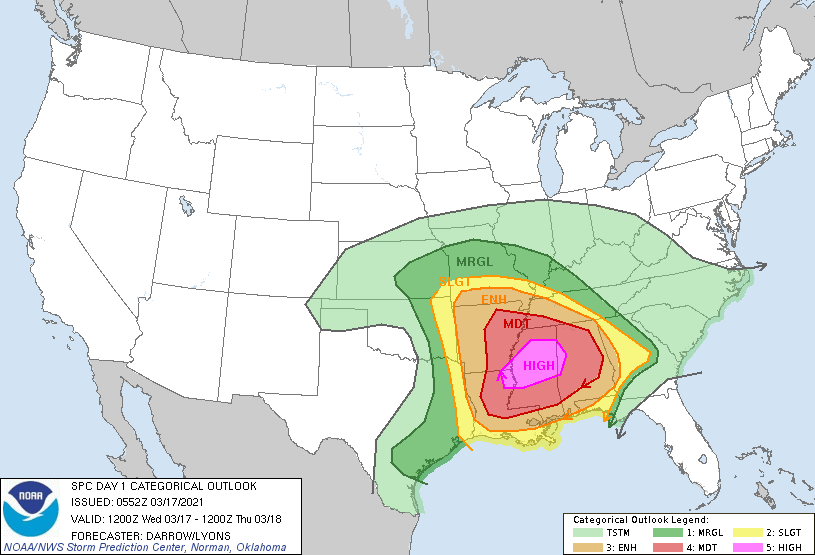
-
2021 Mid-Atlantic Severe Weather - General Discussion
George BM replied to Kmlwx's topic in Mid Atlantic
April of 2019 was better than usual as a whole for these parts. The April 14-15th event could've been something memorable if timing was + or - 12 hours. A lot of moonlit skies between the storms that night once the mid-level dryslot moved overhead. Make that sunshine and add 5-10F then... -
2021 Mid-Atlantic Severe Weather - General Discussion
George BM replied to Kmlwx's topic in Mid Atlantic
With the SLGT getting north of Richmond... though March climatology... Caddy Waddy... I'm low-key watching far southern zones for now, though. -
Very nice. ... So, in other words, the "Saturday Morning" was a similar situation to the Popeyes Chicken sandwich hype from 2019-2020?
-
Nice loops below. Time sensitive. 96 frame (8 hour loop) top. 200 frame (16 hour 35 minute loop) bottom. https://weather.cod.edu/satrad/?parms=regional-central-comp_radar-96-1-25-1&checked=map&colorbar=undefined https://weather.cod.edu/satrad/?parms=regional-central-comp_radar-200-1-25-1&checked=map&colorbar=undefined
-
Another good link to watch and drink. https://www.earthcam.com/usa/colorado/denver/?cam=denver
-
2021 Mid-Atlantic Severe Weather - General Discussion
George BM replied to Kmlwx's topic in Mid Atlantic
Just a bit of happy hour digital CAPE to enjoy with your liquor on this Friday night.
-
IAD has reached 79F so far.
-
See my post in the Cicada thread. You and I are in a precarious position for still being over 8 weeks out from the event.
-
Indeed. Meanwhile I'm precariously close to the southern edge of the forecasted swarm area here in northern VA with over 8 weeks to go. I can't afford any northward shifts.
-
@SomeguyfromTakomaPark and/or any runner out there. Have you experienced Cuboid Syndrome? If you did how did you treat it?
-
Hit the teens for a second morning in a row at IAD.
-
I choose the GEFS option. It will give some of us, especially south, a 1% chance of a MRGL risk.
-
That really sucks that you didn't get to enjoy any of our big HECSs this past decade. Just curious, I assume you're still in high school?
-
The severe event of the year. I wonder what 2022s severe weather season will bring. 48/38 at IAD. It's getting windier.
-
Meanwhile, my liquor life consists of the occasional mouse sip of wine here and there through my childhood... Wait, does wine count as liquor? I's got some studying to do before I'm able to join you adults in discussing this stuff. @Cobalt @Rhino16 @NorthArlington101 you three are in my club. Get the soft drinks, chips and... what kind of pizza do you three like? Maybe some salad and Mediterranean food in case you're trying to be healthier.
-
I'll MOST LIKELY (70/30 odds) survive. My 'discobs' legacy (I say as if I'm some sort of super famous person... CRINGE!!) lives on. What was the first booze (or kind of booze?... I'm bad at talking about beer) that ever entered your body and did you like of taste of that booze?
-
We are a month closer to our next area-wide beatdown.
-
Good morning weather family! I hope you all had a good night last night.


