George BM
-
Posts
3,048 -
Joined
-
Last visited
Content Type
Profiles
Blogs
Forums
American Weather
Media Demo
Store
Gallery
Everything posted by George BM
-
IAD has reached 76F as of a few minutes ago.
-
IAD at 74F.
-
Dulles Airport just gusted up to 42kts (48mph).
-
Good thing the CFSv2 is going to end up dead wrong and it's before the spring barrier anyway (spoiler it wants another Mod LN next winter). (Not that you put any trust in the CFSv2 or any climate model for that matter.)
-
The certificate for tropical tidbits just expired. Hopefully they'll get a new one at some point today.
-
Perhaps we actually get hit by a decent Cape Verde storm this year...
-
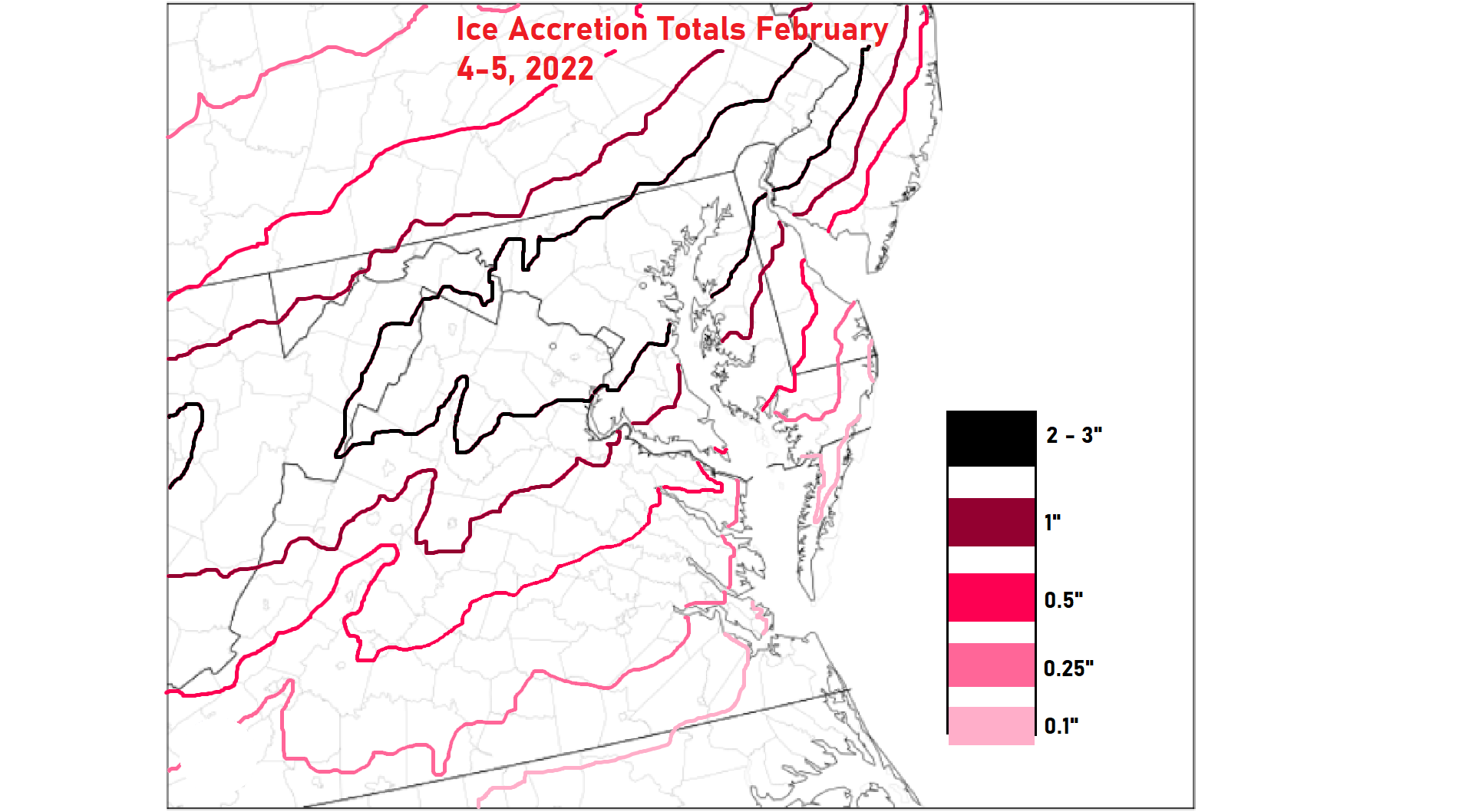
THIS 100%! I'm an extreme weather weenie, NOT a sane normal human-being. I want the extremes. Give me a nice icing event over 30s and rain any day. We get more than enough of the latter. Five inches of ice accretion like during the Great Ice Storm of 1998 in Ontario would be quite interesting.
-
IAD just gusted to 48kts (55mph). RMK AO2 PK WND 29048/1822 T00781106
-
Merry Christmas! URGENT - WEATHER MESSAGE National Weather Service Baltimore MD/Washington DC 218 PM EST Fri Feb 18 2022 DCZ001-MDZ003>006-008-011-013-014-016>018-503>508-VAZ028-031-053- 054-505-506-WVZ052-053-190330- /O.NEW.KLWX.WI.Y.0006.220219T1700Z-220220T0000Z/ District of Columbia-Washington-Frederick MD-Carroll- Northern Baltimore-Cecil-Southern Baltimore-Prince Georges- Anne Arundel-Charles-St. Marys-Calvert-Northwest Montgomery- Central and Southeast Montgomery-Northwest Howard- Central and Southeast Howard-Northwest Harford-Southeast Harford- Frederick VA-Clarke-Fairfax-Arlington/Falls Church/Alexandria- Western Loudoun-Eastern Loudoun-Berkeley-Jefferson- Including the cities of Washington, Hagerstown, Frederick, Ballenger Creek, Eldersburg, Westminster, Reisterstown, Cockeysville, Elkton, Baltimore, Bowie, Suitland-Silver Hill, Clinton, College Park, Greenbelt, Laurel, Camp Springs, Glen Burnie, Annapolis, Severn, South Gate, Severna Park, Arnold, Odenton, St. Charles, Waldorf, Lexington Park, California, Chesapeake Beach, Huntingtown, Dunkirk, North Beach, Lusby, Prince Frederick, Germantown, Damascus, Bethesda, Rockville, Gaithersburg, Silver Spring, Lisbon, Columbia, Ellicott City, Jarrettsville, Aberdeen, Winchester, Berryville, Reston, Herndon, Annandale, Centreville, Chantilly, McLean, Franconia, Arlington, Alexandria, Falls Church, Purcellville, Leesburg, Ashburn, Sterling, Martinsburg, Charles Town, and Shepherdstown 218 PM EST Fri Feb 18 2022 ...WIND ADVISORY IN EFFECT FROM NOON TO 7 PM EST SATURDAY... * WHAT...West winds 15 to 25 mph with gusts up to 50 mph expected. * WHERE...Portions of The District of Columbia, central, north central, northeast, northern and southern Maryland, northern and northwest Virginia and panhandle West Virginia. * WHEN...From noon to 7 PM EST Saturday. * IMPACTS...Gusty winds could blow around unsecured objects. Tree limbs could be blown down and a few power outages may result. PRECAUTIONARY/PREPAREDNESS ACTIONS... Use extra caution when driving, especially if operating a high profile vehicle. Secure outdoor objects. && $$ ADM
-
2022 Mid-Atlantic Severe Wx Thread (General Discussion Etc)
George BM replied to Kmlwx's topic in Mid Atlantic
I too have been watching this period. On the 12z HRRR that's 75+ kt winds at 1km over a good part of the region with the 60kt wind barb at 925mb (2,500ft). Notice how the lapse rates in the lowest km of the atmosphere is, while certainly not "peak daytime-heating" steep, it is a little bit steeper. Now I'm certainly not expecting 75kt wind gusts! But if even some of that mixes down there could certainly be some "that roar woke me up" type gusts. I'll not be surprised at all to see High Wind Watches for, at least the mountains, issued at some point today. If we can stay cloudy tomorrow night w/o any rain showers to cool the near-surface atmosphere ahead of the front, then that would maximize the wind potential.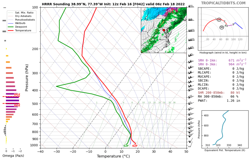
-
2022 Mid-Atlantic Severe Wx Thread (General Discussion Etc)
George BM replied to Kmlwx's topic in Mid Atlantic
Are you talking about the winds with the pre-frontal gradient tomorrow night/pre-dawn Friday or are you talking about the winds w/ the post-frontal surge? Or is the answer to this question just, "Yes". -
Mid-Atlantic forum winter 2021/22 snow totals thread
George BM replied to North Balti Zen's topic in Mid Atlantic
Herndon, VA 11/30/2021: T 1/03/2022: 6.0" 1/07/2022: 4.8" 1/16-17/2022: 2.8" 1/20/2022: T 1/28/2022: 0.8" 2/13/2022: 1.4" ... Total as of February 15, 2022: 15.8" -
2022 Mid-Atlantic Severe Wx Thread (General Discussion Etc)
George BM replied to Kmlwx's topic in Mid Atlantic
My two (non-expert) cents: For Thursday night/early Friday the main threat would be gusty winds from a thin line of heavy rain along the cold front. As it looks right now, the trough seems too positively tilted for anything too significant especially given the (at most) maybe 200J/kg CAPE. It's the strong winds aloft with these off season systems which the heavy rains can bring down to the surface. The cold front and the flow don't look too far from parallel though (cold front orientated from 7:30-1:30 w/ mean flow from 8-2), less than 30 degrees. This limits the wind potential with convection. With the February 7th, 2020 event that brought 50-60+mph wind gusts and tornadoes especially in northern MD, the trough was negatively tilted with the mean flow and the cold front more perpendicular (line of low-topped storms extending from NNW to SSE w/ mean flow from the SW). That combined with a strong sub-980mb low moving along the Blue Ridge mountains helped back surface winds to the southeast creating high low-level shear which lead to lots of bowing segments along that line with tornadoes forming along the kinks of said line. An event like that is probably the only way to get more widespread severe in these parts this time of the year (not that you or anyone here implied there could be widespread severe later this week. ). -
Feb 12/13 Event Quest for Blues to Envelop More Rather Than Less
George BM replied to North Balti Zen's topic in Mid Atlantic
I'm wishing that this disturbance moved across the region during the daytime. Daytime heating, though heating the surface and leading to snow melt, would allow for more numerous and intense snow showers/squalls popping up distributed more evenly across the region. It could certainly still be fun for some late overnight/pre-dawn. -
Feb 12/13 Event Quest for Blues to Envelop More Rather Than Less
George BM replied to North Balti Zen's topic in Mid Atlantic
Time sensitive but very cool radar loop of a meso-low over Cleveland Ohio... https://weather.cod.edu/satrad/nexrad/?parms=CLE-N0Q-1-96-25-usa-rad This is part of the energy that will swing through late tonight. -
63 currently at IAD after a low of 23.
-
Looks like we may actually see widespread low 60's or so for highs today.
-
https://www.weather.gov/wrh/climate This is a good place... at least for our local airports. I'm not sure how other forecast offices display their climate data. Just click on the forecasting area you want and that should lead you to a lot more climate data is they have it.
-
The 6z 3km NAM shows light ZR/possible needles over much of the area tomorrow morning through midday/early afternoon hours. Just something to watch... ...I'm also aware of how well it did with temps for Wednesday of this past week. But still... something to watch assuming precip makes it far enough NW.
-
Looking at this picture I get the feeling that a large 60-foot tall lanky creature/monstrosity is about to emerge from the fog. ETA: 50/48 at IAD. Light misty rain/drizzle.
-
"Command" ahahaha. Command... *sigh*
-
Non-expert thought: I wonder whether this has to do with how the NAM is handling the interaction between the snowpack over the Delmarva and the near surface air and how it's handling the albedo effect. Skew-t's on the 3km NAM suggest that low clouds move in from the east overnight/pre-dawn tomorrow morning and hang around all day while none of the other models do this.
-
We've reached the point where mornings are starting to brighten earlier. 25/14 at IAD.