

George BM
-
Posts
2,990 -
Joined
-
Last visited
Content Type
Profiles
Blogs
Forums
American Weather
Media Demo
Store
Gallery
Everything posted by George BM
-
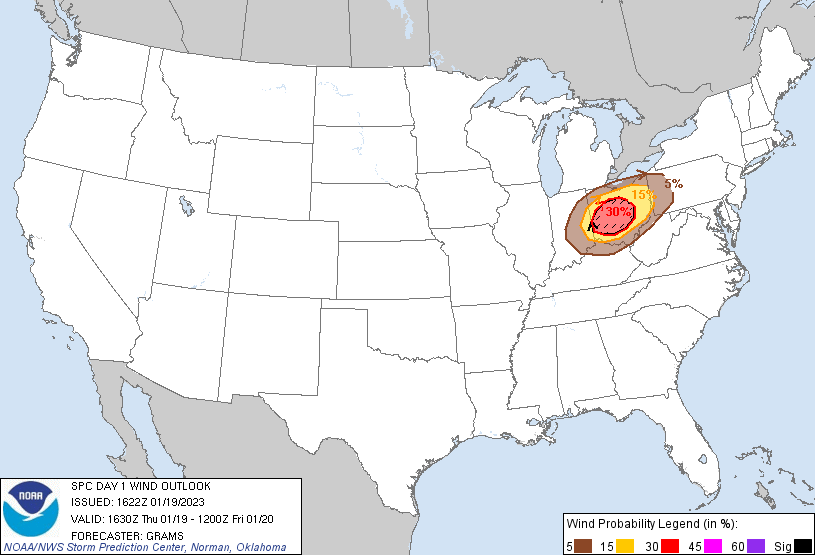
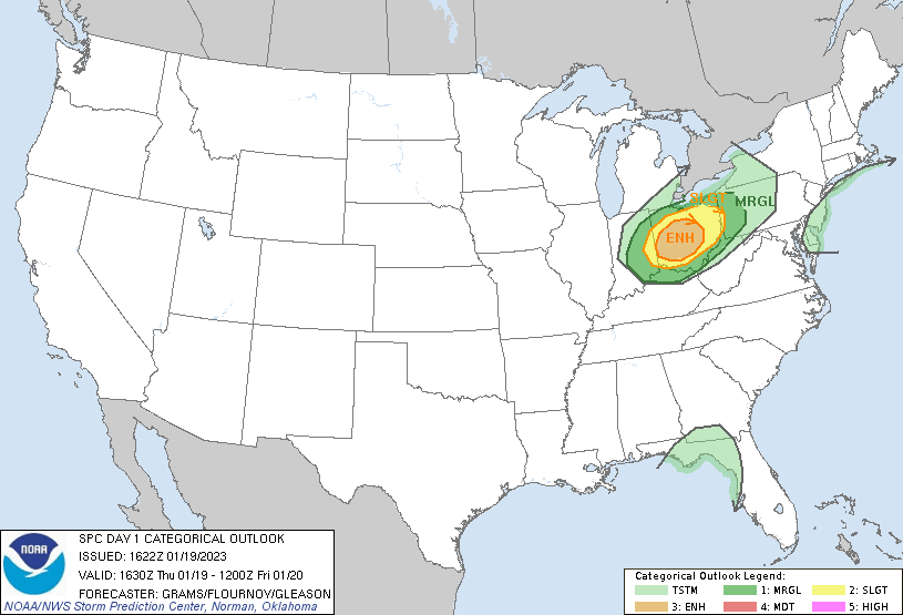
Forecast Discussion April 27, 2023 4:25PM EDT Hard Freeze Warning in effect from 10PM EDT Thursday, April 27, 2023 until midday Saturday, April 29, 2023 For far northern and western areas- Wind Chill Advisory in effect from 2AM EDT Friday, April 28, 2023 until 10AM EDT Friday, April 28, 2023 This evening through Friday: An arctic front will pass through the region as we go through the evening w/ a line of heavy gusty showers and an embedded thunderstorm along it. These may be accompanied by 30-40 mph wind gusts and, given the cooling air aloft, a non-zero chance of small hail. Once the front has blown through to our southeast by the mid/late evening hours temps will fall rapidly through the 40s and 30s and fall below freezing… perhaps even into the upper 20s by midnight. Any remaining wet spots on surfaces outdoors will freeze overnight. Temps will continue to fall through the predawn hours on stiff NW winds gusting between 30 and 40mph. By dawn on Friday morning w/ 850mb temps dropping to around -18 to -20C, temperatures will range from near 20F in southern MD and towards central VA, to the mid/upper teens in the Greater Metropolitan area, to the lower teens in the coldest far NW suburbs. With the strong NW winds in place wind chills will range from the mid-single digits in central VA/southern MD to around zero in the Greater Metropolitan area to around 5 to 10F below zero in the far NW suburbs where the Wind Chill Advisory is in effect. Being that it’s the end of April, the surface waters of the Great Lakes have warmed to around 7-8C+. So scattered lake-effect flurries and snow showers can be expected across the region through the morning. By midday a secondary disturbance approaches from the NW with even colder air aloft. With very steep lapse rates from the surface up to around the 500mb level intense snow squalls, perhaps even w/ a lightning strike or two, will transverse the area bringing strong gusty winds and brief whiteout conditions. Some spots may receive a quick coating to an inch of snow w/ slick roadways. Temps will generally range from the upper 20s to lower 30s by the early afternoon but will probably drop into the middle 20s with the snow squalls. Friday night/Saturday morning: Snow showers and squalls will slowly taper off through the night as temps fall into the teens areawide. Winds will diminish from gusty during the evening to breezy overnight. By dawn on Saturday temps will range from around 10F in far NW suburbs to the upper teens towards central VA/southern MD before rising above freezing into the mid to upper 30s during the afternoon with winds continuing to diminish. Three Days Later Forecast Discussion April 30, 2023 3:33PM EDT Blizzard Warning in effect from midnight EDT Monday, May 1, 2023 until 6AM EDT Tuesday, May 2, 2023. Through tonight: With the record breaking cold airmass that has been in place over our region for the past couple of days temperatures this afternoon have only risen to within a few degrees on either side of 40F under an increasingly overcast sky. Snow will move into southwestern areas through the early evening hours… perhaps starting as a wintry mix of rain/snow/pellets before dynamic cooling turns precip into all snow. Precipitation will move into the immediate area by sunset with any mixed precip changing to snow within a few hours of the onset. This is associated with a strong shortwave trough moving ESE towards the southern Mid-Atlantic coast. As said shortwave approaches the coastline it will take on a negative tilt allowing a surface low to rapidly intensify over southern VA. This surface low is expected to become a deep sub-980mb low over southeastern MD by around midday tomorrow. Through the rest of the evening snow will overspread the rest of the forecast area and pick up in intensity as winds start increasing out of the NE. Snowfall will become heavy by the overnight hours with winds gusting to around 40 mph or so leading to visibilities dropping to below a quarter mile hence the blizzard warning. The snow will be wet with snow to water ratios around 6-8:1. The heavy wet snow combined with the strong winds will lead to scattered power outages through the predawn hours. Monday through Monday night: The worst part of the storm will occur between dawn and dusk on Monday as the surface low stalls and deepens to the upper 970s in millibars. Liquid precip rates may exceed half an inch per hour which would translate to snowfall rates of 3-4”+ per hour. This coupled with winds gusting over 50mph trough the entire day will lead to catastrophic tree damage and widespread power outages. Visibilities will drop to below 1/16 of a mile (roughly 300ft) at times throughout the day. Travel is… you know what just don’t travel tomorrow. Trees will be down in roadways and covered by fresh snow. You will get stuck… for a long time. This is a once in a lifetime-type blizzard. As we go into the evening hours the snow will slowly start decreasing in intensity and eventually taper off from west to east by the predawn hours of Tuesday. After all is said and done snowfall totals of 30 to 42 inches with locally higher amounts of up to 4 feet, especially in the mountains can be expected. Drifts will, of course, be much higher given the high winds throughout the duration of this event. One unique consequence of this event occurring at the start of May is that trees, especially following the above normal temps experienced before this arctic blast, are near if not already at full leafout outside of the mountains. A vast majority of deciduous trees will not make it beyond this storm. With how heavy and wet the snow will be there may be many roof, and even building, collapses. This will be very costly storm for the region. You should have batteries for radios along with water and non-perishable foods for at least the next few days. Good luck to all. Forecaster Wannabe: George BM
-
That was a VERY noticeable and unique thing about last summer that stood out to me. The number of times there was CIN east of the Blue Ridge w/ the strongest instability along and west of there was odd. Fingers crossed for more NW-flow ring-of-fire MCSs this year... preferably w/o too much of that CIN.
-
The “is it ever going to snow again” discussion.
George BM replied to psuhoffman's topic in Mid Atlantic
That'd be pretty cool actually. Lets do it! Sorry, @mappy. -
Sleeping hits hard.
-
2023 Mid-Atlantic Severe Wx Thread (General Discussion)
George BM replied to Kmlwx's topic in Mid Atlantic
Give me a negatively tilted trough w/ a surface low tracking up the Apps spine during spring and a classic ROF pattern for the second half of May through the summer every year. This is the way to win. -
11/15/2022: T (sleet) 12/10/2022: T (sleet) 12/22/2022: T (rain w/little SN/IP mixed in) 12/23/2022: T (30 sec graupel squall. The following hour... 5-10min SN/SN+) 1/08/2023: T (few sleet pellets) 1/22/2023: T (few sleet pellets at onset) 1/25/2023: T (rain/sleet mix) Total as of January 26, 2023: T
-
The thing is that one needs to be careful to not make the rookie mistake of adding the date and year without clicking "Sterling-Dulles area" as BWI would show by default when clicking "Go" as it's at the top of the list. The person who brought this up wasn't careful and made said rookie mistake.
-
I'm talking about the daily average when you combine the high/low temp of the day. https://www.weather.gov/wrh/Climate?wfo=lwx
-
Fun fact: IAD is yet to have a below average temperature day this month. BWI
-
Won't post because of what model it is at the end of its run but... HRRR says "Choo choo snow train!"
-
It's a good thing that you've experienced a lot of extreme weather over your six decades on this planet. Imagine our luck when you figure out how to use all of that accumulated jojo to give us a 1978 Midwest style triple phaser... or a snow squall with 3 foot visibilities... or a 105-110F heatwave w/ 80+F dewpoints that bring us a super derecho. Train well my good friend.
-
2023 Mid-Atlantic Severe Wx Thread (General Discussion)
George BM replied to Kmlwx's topic in Mid Atlantic
- 2,785 replies
-
- 5
-

-
- severe
- thunderstorms
- (and 3 more)
-
Possibly some lightning/thunder from modestly elevated convection.
-
I'm wishing your daughter a speedy recovery.
-
2023 Mid-Atlantic Severe Wx Thread (General Discussion)
George BM replied to Kmlwx's topic in Mid Atlantic
I'm wondering if limited, slightly elevated CAPE will be enough for a few to hear thunder tomorrow evening. -
IAD got down to 23F. 0.01"-0.02" of frost. On the board!
-
Frost ice or precip ice?
-
IAD down to 23F.
-
Any thunder/lightning?
-
Another year over. A new one begun. What weather event stood out most to you? 2022 was not too memorable IMBY (again). One memorable event that I will point out that occurred IMBY in 2022 was the wake-low of January 16th, 2022. In the 10pm hour that night, climaxing between 10:30-10:45pm, I experienced ENE winds that were gusting upwards of 50 mph or so as a solid shield of moderate rain lifted northeastwards and the surface air pressure dropped several mbs in under an hour. I'm sure people such as @MN Transplant can look back at their data at that impressive pressure drop. Curious to hear what you all have to say about this past year. I know some of you got whacked by summer storms.
-
A Vibrant Sunset Advisory has been issued for the Greater Baltimore/DC Metropolitan region in effect from 4:50pm until 5:30pm est Wednesday, January 4, 2023. High clouds are clearing out to the west of the Blue Ridge Mountains with limited lower-level clouds to the WSW into southern WV. As sunlight reflects off of the base of the high clouds vibrant sunset colors may appear. The most vibrant part of the sunset will be between 5:00pm and 5:15pm. Forecaster Wannabe: George BM
-
A record is just about certain at IAD (51F is the record high min for 1/4 there). DCA RHM (1/4): 60F (slight chance) BWI RHM (1/4): 61F (non-zero chance) Just wonder exactly when tomorrow nights cold front moves through.
-
What I was referencing earlier.
-
Off the top of my head, Jan 21, 2007 was the first measurable snow event for DC that season. It went on to actually be okay. The obvious caveat being that it was a Nino winter.
-
@psuhoffman Don't know whether you saw this yet... but there's something potentially "eye-opening?" I saw on twitter (yes I know don't shoot me yet) about mid-latitude (30-60N) SSTs over the last nearly century and a half for Nov-Dec.

