George BM
-
Posts
3,034 -
Joined
-
Last visited
Content Type
Profiles
Blogs
Forums
American Weather
Media Demo
Store
Gallery
Everything posted by George BM
-
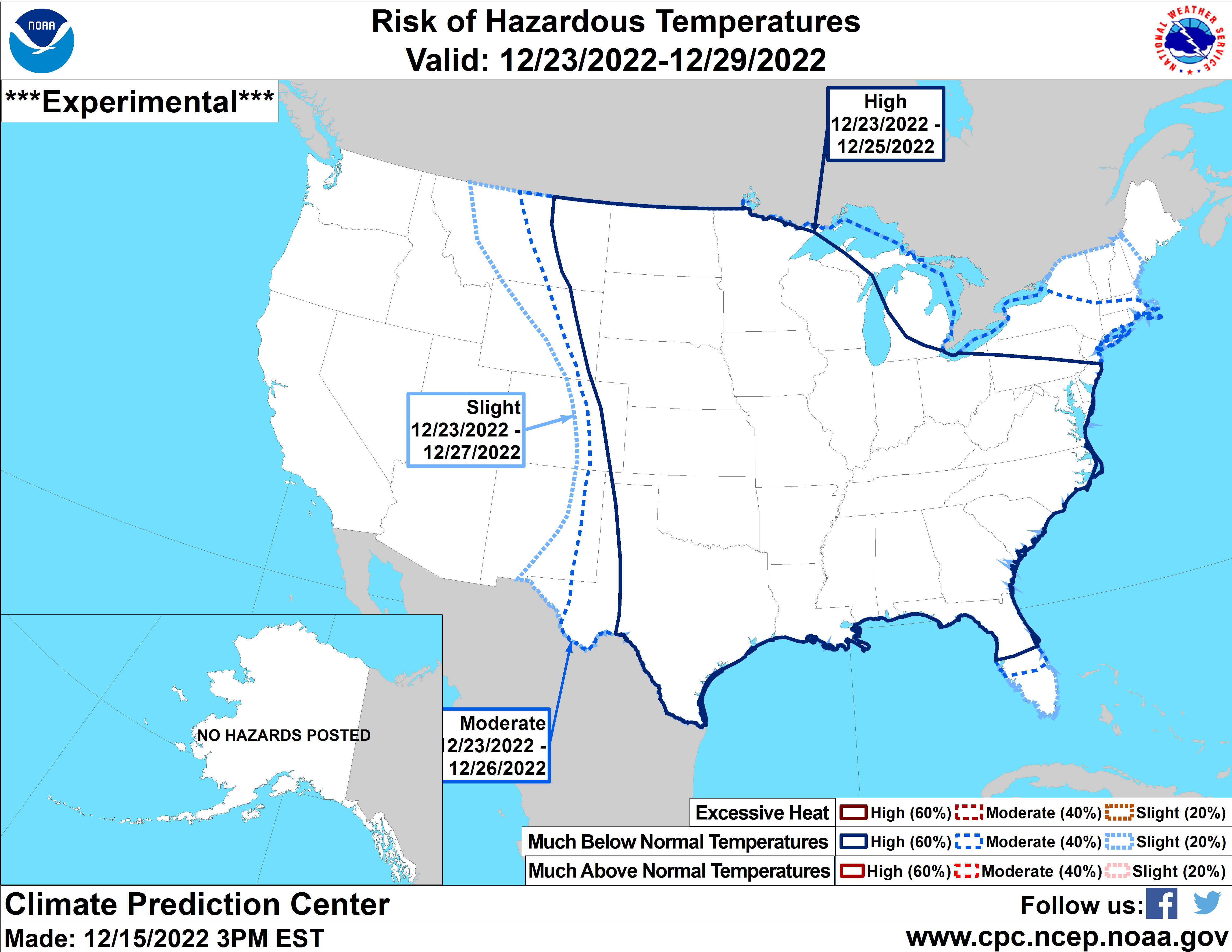
The earlier the thaw, the earlier the reload!
-
2022 Mid-Atlantic Severe Wx Thread (General Discussion Etc)
George BM replied to Kmlwx's topic in Mid Atlantic
We'd finally get back our long lost MOD risk day. TOR: 15%, WIND: 45%(hatched), HAIL: 5% -

-
2021 comes to mind. Weird peak temps across the main airports.
-
33F rain > HECS ... Carrot Cake > 33F rain Down to 33F earlier with rain and a glorious jog in it. #blessedindeed Stay safe and enjoy your carrot cake today!
-
Down to 20F at IAD this morning. Currently 23F. Could be a cold one with high clouds already overspreading the region that will slowly thicken throughout the day.
-
Yeap. January 25, 1985... The year that you're not too fond of.
-
I've noticed that the data from CPC analogs apparently only goes through 2009. Do you or anyone in here know where can I find analogs from 2010 onwards?
-
Affirmative.
-
Down to 21F at IAD this morning.
-
The event IS based off of the V-Day 2015 snow squall... but a weenier version of it during the daylight hours... and on everyones favorite day of seeing snow. So yes... you wouldn't be wrong to say it's similar to that event.
-
I think you all know what's now upon us.
-
Forecast Discussion Sunday, December 25, 2022 1:00PM EST Winter Weather Advisory in effect until 5pm est, Dec 25, 2022 High Wind Warning in effect until 8am est, Dec 26, 2022 Wind Chill Warning in effect from 8pm est, Dec 25, 2022 until 10am est Dec 26, 2022 The next 36 to 48 hours will be very notable in the sensible weather department. An intense snow squall w/ occasional lightning associated with the arctic front is currently moving east through the Appalachian mountains at around 50 or so kts. Snow Squall Warnings are already in place extending from eastern WV to the I-95 corridor. With increased sunshine associated with the mid-level dryslot moving overhead surface temps ahead of the line have warmed up into the upper 30s/lower 40s while dewpoints remain relatively high in the mid/upper 20s across the DC and Baltimore metros. With the very steep environmental lapse-rates immediately ahead of the front a couple hundred j/kg of MLCAPE has developed. This combined with the extreme forcing along the front courtesy of the impressive dynamics associated with the shortwave through swinging through and strong deep-layer shear in place (especially considering the thermodynamics) may lead to even further intensification of this low-topped convection. Lots of areas in northern WV received a quick 1 to 3 inches of snow from this squall. While temperature east of the mountains are well above freezing even more extreme snowfall rates, owing to the increasing instability that the system is moving into, will offset the effects of initial melting and graupel mixed in with the snow so that snow totals are similar east of the mountains. Snow Squall Impacts: 1. Widespread severe wind gusts (55-65+ mph) will accompany this squall leading to scattered to numerous power outages and many downed trees. 2. Instantaneous snowfall rates of several inches per hour will lead to whiteout conditions w/ visibilities dropping to 100 feet or less at times. Snowfall amounts will total 1 to 3 inches w/ locally higher amounts possible. 3. Temperatures will rapidly fall from near 40F into the 20s in a matter of minutes leading to flash freeze conditions across the entire area as the system moves through. All of this will combine to make travel virtually impossible for a time. Use extreme caution and avoid travel until the squall has passed. Even then, use extreme caution with icy roadways and downed trees/powerlines. Other than wind and snow, the temperatures tonight and tomorrow will be the main story. West-northwesterly winds will remain very strong with sustained winds of 25 to 40mph and gusts to around 60mph through the evening and much of the night. Winds will still be gusting to around 45mph by dawn Monday morning. Meanwhile, temperatures will fall through the 10s and into the single-digits through the evening and overnight hours bottoming out in the lower single-digits in the urban corridor and southeast areas w/ lower negative single-digits well northwest and around 0F in the close-in NW suburbs. Wind chills will hover around 20 to 30F below zero across the Greater Metropolitan area throughout the overnight hours until dawn w/ windchills falling to as low as 35F below zero in far northwestern suburbs. Temperatures will only rise into the mid-10s or so during the afternoon with wind chills remaining around 0 to -5F with the still brisk though, by then, sub-advisory level winds. With diminishing winds and clear skies Monday night into Tuesday morning leading to decent enough radiational cooling conditions, temperatures may drop to as low as -5 to -10F in the coldest northwestern suburbs and valleys with temps probably remaining at or just above zero in urban areas and near the bay. Alerts: Winter Weather Advisory in effect until 5pm est, Dec 25, 2022 High Wind Warning in effect until 8am est, Dec 26, 2022 Wind Chill Warning in effect from 8pm est, Dec 25, 2022 until 10am est Dec 26, 2022 “Forecaster”: George BM
-
Lol you thought! Update: BWI: 52.4" DCA: 39.5" IAD: 57.2" RIC: 30.7" Tiebreaker (SBY): 31.0"
-
BWI: 3.5" DCA: 0.9" IAD: 3.1" RIC: 6.0" Tiebreaker (SBY): 6.2"
-
Is anyone on here in Montgomery county without power due to the small plane that flew into high-voltage powerlines?
-
I've been looking at that. That's a strong and fast moving cold front. Whether we get a pressure surge w/ rapid pressure rises and/or sufficient mixing immediately behind the front or not, I could definitely see the potential of a line of strong gusty low-topped convection along said front.
-
A low of 24F at IAD this morning... It has already risen to 57F at not even 10:30am.
-
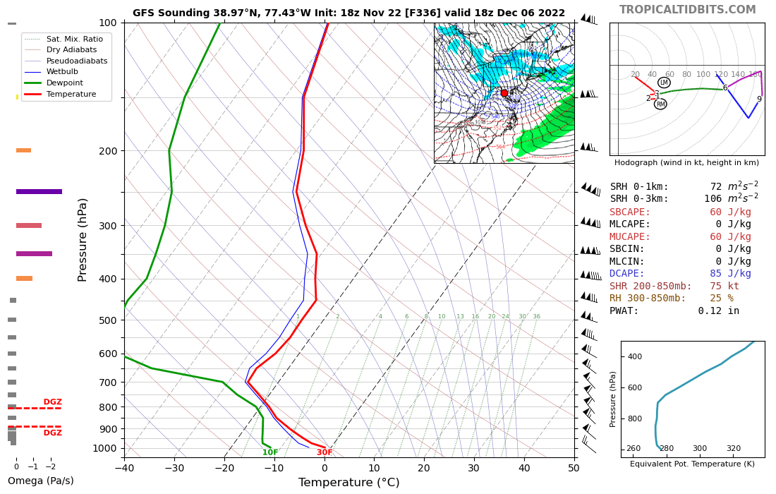
Not digital snow but... that's quite the digital wind event showing up on the happy-hour gfs for 12/6. I love the 60-65 kt winds at 1km within a dry-adiabatic lapse rate, strong CAA environment.

-
Nice purple hue in the western sky currently post-sunset.
-
Yeah. My lips have definitely noticed.
-
Yes there are: A little piece of heaven. That's what you experienced last night.
-
Yeap. A disturbance w/ associated cold front will pass through this afternoon/evening a few light showers/snow showers could form near the front. The further north and east you are the better the chances of you getting hit by a brief shower or two.
-
We'll get ours next week Wednesday.