George BM
-
Posts
2,906 -
Joined
-
Last visited
Content Type
Profiles
Blogs
Forums
American Weather
Media Demo
Store
Gallery
Everything posted by George BM
-
Torrential rain I just received from this activity in Herndon.
-
MCD out for the immediate region. Mesoscale Discussion 1044 NWS Storm Prediction Center Norman OK 0249 PM CDT Fri May 30 2025 Areas affected...Parts of eastern VA...MD...DE...northeastern NC...and far southeastern PA Concerning...Severe potential...Watch likely Valid 301949Z - 302145Z Probability of Watch Issuance...80 percent SUMMARY...The risk of damaging wind gusts and a few tornadoes will increase in the 22Z-00Z time frame. A watch will likely be issued for parts of the area within an hour or two. DISCUSSION...Latest surface analysis shows a surface low over northern WV, with a quasi-warm front extending eastward across MD into southern NJ. Along/south of the front, diurnal heating within cloud breaks and lower/middle 60s dewpoints are contributing to around 1500 J/kg MLCAPE. As storms spread/develop eastward into the destabilizing air mass, 40-50 kt of effective shear should favor gradual intensification/organization into semi-discrete clusters and supercells. Enhanced clockwise hodograph curvature (around 150 m2/s2 effective SRH) ahead of the east-northeastward-moving surface low will support the potential for a few tornadoes (along with locally damaging wind gusts) with the more organized supercells that evolve. A watch is likely for parts of the area within an hour or two. ..Weinman/Smith.. 05/30/2025
- 1,281 replies
-
- 1
-

-
- severe
- thunderstorms
- (and 2 more)
-
Oh wow. I wasn't paying enough attention to the overnight wind threat. We'll see what happens. Definitely looks to be a windy system for the end of May. Surface low currently looks to be wrapping up a bit just south of the Kentucky, Ohio, West Virginia intersection.
-
Lol 13z HRRR is loltastically aggressive with a sting-jet feature overnight bringing 50-60mph wind gusts from northern VA through DC and southern MD... No I don't see it getting THAT windy.
-
T
- 1,281 replies
-
- 2
-
-

-
- severe
- thunderstorms
- (and 2 more)
-
Yeah. I know exactly which CAM prompted that reaction from you... just have the MCS track 60-75 miles further north and...........
-
2.21" since the night before last.
-
Yeah seems hard to believe it's been that long when you think about it. Since Jan 2024 there's seemingly been this invisible barrier preventing me from breaking 2" of rain during an event. I got close a couple of times with a couple of 1.8"+ events. I got 1.97" from Debby last year. But finally today the two-inch mark has been fully eclipsed.
-
I'm up to 2.04" here in Herndon, VA. Wettest event here in at least 16 months. 4.04" for the month of May so far.
-
1.30" for this event so far. Not bad.
-
0.67" thus far. 2.67" for May thus far. Strong reflectivities approaching from the southeast. (Herndon, VA)
-
Another 0.56" of rain yesterday brings me up to 1.32" for the event and 1.33" for the month of May so far.
-
0.76" for me so far during this event. (Herndon, VA)
-
May already? Geeze. Looking forward to pollen-washing and drought-denting rains.
-
Forecast Discussion Sunday May 25 2025 3:08PM EDT This has been a destructively wet month for much of the region with back-to-back coastal lows/ nor’easters dropping 3-7” and 5-10” of rain across the forecast area. Followed by rounds of, sometimes, training thunderstorms early this past week tracking from WSW to ENE dumping another 4 inches to up to a foot of rain with parts of Montgomery and Howard counties into Baltimore getting those 10-12”+ totals. Needless to say, the drought that has been affecting much of the region over the last year or so has come to an abrupt end. Now this afternoon, another very dangerous situation is in the process of unfolding. An MCS is currently moving across northern MD with severe thunderstorm warnings out for wind damage as well as severe hail. A Severe Thunderstorm Watch is in effect for everyone north of Fredericksburg and Culpeper, VA and north of southern MD until 10pm local time tonight to account for these storms and training thunderstorms that will develop over the Greater DC metro. With 2000+ J/kg MLCAPE and decent effective bulk-shear (~40kts) there could be embedded supercell structures that produce severe hail (1-2” in diameter). The magnitude of CAPE and moisture will cause localized strong to severe downburst winds with any embedded downbursts/microbursts as well. The main story this afternoon and evening, however, will be from flash flooding from the storms that will start training over the same areas for several hours. Have issued a Flash Flood Watch is in effect for the entire forecast area until 4am. Decent low-level southerly flow will allow the storms that develop and back build to the south and west of the main MCS to be continuously reinvigorated as warm/moist/unstable air continuously lifts as it meets with the rain-cooled airmass to the north. Pwats of 1.75-2”+ will also make these storms efficient rainmakers. As a result, some areas could get several hours of 1-3”/hr rainfall rates leading to rainfall totals as high as 8-12” w/ locally higher amounts. A wave of energy will move along the front through the region this evening briefly allowing rain and storms to become more widespread. There could still be a few severe storms, mainly from the Potomac River and Route 50 southwards in MD where the airmass will be most unstable. As the wave moves to the east all the rain and storms will move out with it, exiting the Chesapeake Bay by 3am or so. However, the damage will be done by then. We will get another brief reprieve through midweek with slightly above average temps and humidity (High in the 80s w/ mid/upper 60s dewpoints) before, unfortunately, our attention turns to newly formed Tropical Storm Barry located in the western Caribbean Sea. Models are slowly starting to come into better agreement that Barry will move north and then northeast across Florida before interacting with a shortwave trough that may pull the storm back north into eastern North Carolina or into the Chesapeake Bay by late week bringing a threat of significant rains as well as gusty winds depending on how strong the tropical system is.
-
0.17" of rain from a downpour early in the 2am hour that didn't wake me up due to there being no lightning with it.
-
Now you know what to do come wintertime.
-
84 for a high today, warmest day of the year so far.
-
0.79", 2.43" for the month
-
Looking at the positive side if this is the case... I'm looking forward to us getting Cedar Rapided with 100-140+ mph wind gusts.
-
I can still faintly see light in the western sky after 9pm! Long days are upon us.
-
IAD w/ a 48kt(55mph) wind gust.
-
Currently 61/33 at IAD w/ a peak gust of 45mph so far.
-
March 2nd, 2018 was epic.
-
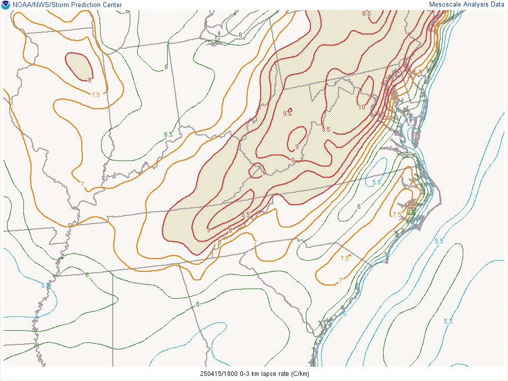
SPC mesoscale 18z analysis showing 0-3km lapse rates of 10+C/km stretching from Carroll County, MD down southwest through Prince Williams County, VA. That will help any showers bring down enhanced wind gusts this afternoon.