DownpourDave
-
Posts
1,353 -
Joined
-
Last visited
Content Type
Profiles
Blogs
Forums
American Weather
Media Demo
Store
Gallery
Everything posted by DownpourDave
-
maybe this is a dumb question, was the max storage increased to 50 mb recently?
-
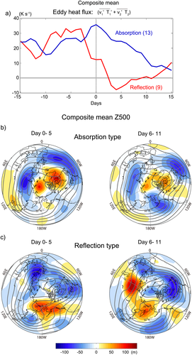
Could it be that the SSW was a reflection type so it ruined the blocking pattern? Pulled directly from the paper Cite: Kodera et al, 2015 https://agupubs.onlinelibrary.wiley.com/doi/full/10.1002/2015JD023359 What are your thoughts? Just thought I would try and search for an answer looking at past research. Edit: There is obviously a lot to this paper but what I got was that not all SSWs necessarily lead to a blocking pattern (-NAO/-AO)
- 2,509 replies
-
- 1
-

-
- weenie fest or weenie roast?
- weenies got roasted
- (and 2 more)
-
I might decide to do my thesis on it. Any suggestions for a title? Half kidding but I really might.
- 2,509 replies
-
- 2
-
-
- weenie fest or weenie roast?
- weenies got roasted
- (and 2 more)
-
Have any of the mets here done Pathways? Going to go for it with several Student Trainee Positions opening up in Meteorology(https://www.usajobs.gov/Search/Results?j=1399). I know they accept undergraduates as well but I am hopeful I have a shot as a graduate student.
-
Jan Medium/Long Range Disco 2: Total Obliteration is Coming
DownpourDave replied to Jebman's topic in Mid Atlantic
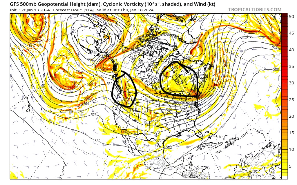
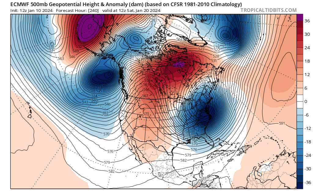
Copied from a post I made on a different site: Okay I identified these two areas as important. The shortwave over BC, and the TPV. You want the TPV further east and that shortwave a little more amplified and orientated more North to South. In terms of the shortwave over BC the 12z euro is an improvement over the 6z gfs but not as good as the 12z gfs. The reason why the 12z euro looks bad is because of the less favorable TPV position. I will be paying close attention to the position of the TPV over the next few runs as well as seeing how much that vort coming in from the Pacific is able to amplify and have a more favorable orientation
-
Jan Medium/Long Range Disco 2: Total Obliteration is Coming
DownpourDave replied to Jebman's topic in Mid Atlantic
-
Jan Medium/Long Range Disco 2: Total Obliteration is Coming
DownpourDave replied to Jebman's topic in Mid Atlantic
@psuhoffman I see almost nothing wrong with this map. PNA in a perfect spot, semblance of a 50/50, almost as good as a “look” can get. Even has that trough over Alaska which you typically see before a big snowstorm for the EC.
-
Jan Medium/Long Range Disco: Winter is coming
DownpourDave replied to stormtracker's topic in Mid Atlantic
With a -3 or -4 sigma NAO don’t you need a -PNA anyways, like a +PNA wouldn’t work, again long range and analyzing teles are not my strong suite. -
Obviously it’s past the deadline but I might post a late entry just for fun later today.
-
You know…. sometimes I forget you don’t have a degree in this stuff, you really know your shit. My degreed PhD Research Advisor could learn a thing or two about long range forecasting(teleconnections in particular) and frankly, so can I. I am much better at short range forecasting, looking at different weather maps(upper level charts, surface analysis maps), and forecast what will happen in 1-3 days. Love using bufkit and MOS which are obviously much better for short range forecasting.
-
Have you actually done your own research/collect data to back that up? That there is a small correlation?
-
You’re right that you can, my point is it is harder. The answer is a bit complicated. Part of the answer is in the physical process of rain and snow formation and how fast they fall. Rain forms through liquid droplets coalescing in the atmosphere creating larger and heavier droplets that can fall quicker under the force of gravity Snowflakes form when water vapor turns directly into ice crystals. Snowflakes form at a slower rate than rain droplets and obviously the structure is different with air pockets within the snow flake causing them to be lighter than rain drops. Thus, Rain can physically fall at a faster rate than snow and rain forms at a faster rate. This explains it better. https://geo.libretexts.org/Bookshelves/Geography_(Physical)/The_Physical_Environment_(Ritter)/07%3A_Atmospheric_Moisture/7.04%3A_Clouds_and_Precipitation/7.4.03%3A_Precipitation_Process Bergeron Process vs Warm-Rain Process Now assuming that one is dealing with the Bergeron Process for areas that get rain and areas that get snow, rain will still fall at a faster rate due to structure differences between a snow flake vs rain drop.
-
No need to imagine, the way thermodynamics work, it wouldn’t be that QPF if it were snow. It is why you can get 3 inches of rain per hour but not 30 inches of snow per hour. It doesn’t work like that.
-
It just filled in now.... strange the data is now all there.
-
I checked the raw data file, it seems the data simply stopped transmitting and is missing. I wonder if maybe they ran into some instrumentation issues/communication issues?
-
Looks like reconnaissance on Lee will begin tomorrow 07/2330z.
-
I was hoping it would be a little bit snowier than Geneva in the Finger Lakes region of NY. I am a skier so I am hoping for enough snow for that! I did hear there are many great ski resorts near where I am.
-
Just moved to Plymouth NH to start my masters degree. Anyone around there that can give me a sense of the winters up here?
-
Near S concord road and Brinton lake road

-
Not that it matters that much but Icon just made a step toward the gfs camp.
-
The critical features to observe that have a domino effect to the rest of the run are only 3-4 days out but your point is valid.
-
Spoiler: It won't be as a good as the gfs.
-
The good news is the differences between the favorable solutions and unfavorable solutions GFS and CMC respectively can be traced back to the shortwave over Alaska at 54 hours. Meaning this model "war" should end relatively soon. One should cave "soon"
-
E PA/NJ/DE Winter 2022-2023 OBS Thread
DownpourDave replied to Ralph Wiggum's topic in Philadelphia Region
It really does seem like the PNA getting that right is one of the most important ingredients. -
Upstate/Eastern New York-Into Winter!
DownpourDave replied to BuffaloWeather's topic in Upstate New York/Pennsylvania
Geneva actually getting lake effect snow? What is this!!!