
BooneWX
-
Posts
1,320 -
Joined
-
Last visited
Content Type
Profiles
Blogs
Forums
American Weather
Media Demo
Store
Gallery
Posts posted by BooneWX
-
-
2 minutes ago, Brick Tamland said:
Sone of you must have forgotten what happened with the models with the storm we just had.
It’s just dependent on where you’re at. A lot needs to change to bring some of us into the game. Raleigh area, yea I’d agree. Not too much needs to trend better to at least get a few inches.
-
 1
1
-
-
No hope is lost until the RGEM has a say so
-
2
-
-
NAM ticked sw again
-
3
-
-
12 minutes ago, Ghicks said:
Looks to be better odds In the east than in the foothills if I’m looking at this correctly
It’s really too early to say. At the moment, sure, but we’re 4 days out and a slight tick here or a slight tick there can mean a foot in the west or a foot in the east. The fact that a large area of the southeast gets love from the ensembles shows the lack of consistency right now. Atlanta to DC and all in-between are in play.
-
1 minute ago, wncsnow said:
One thing is certain, it's going to get super cold and windy as the st
.thumb.png.1e1e62c74953a8569eabeb225ca08c80.png) orm bombs out off the NE coast.
orm bombs out off the NE coast.
Going out with a bang before the milder pattern!
-
20 minutes ago, Sandstorm94 said:
That also depends if it phases with the trough, if it does it would follow the gradient
Sent from my SM-S115DL using Tapatalk
Selfishly im rooting for an early phase

but if y’all pull off a historic storm right after this weekend, I’ll be cheering strongly for everyone down east.
-
3
-
-
56 minutes ago, Tyler Penland said:
Looks like the weekend storm is coming back to us a bit.
Also Robert thinks we could see some elevation dependent snow tomorrow under the jet streak.
I hope so. Too early to give up hope but it’s been looking I-95 ish the last few days.
on the flip, I highly doubt something so amped stays so far out to sea. If it comes in as strong as some ensembles show, it’s going to hug the coast, if not go inland a bit.
-
19 minutes ago, GunBlade said:
Yea we need that ULL diving down from the arctic to be a little stronger and/or slower to help those waves dive down more in the plains instead of coming down through the Midwest/Ohio Valley.
Canadian is showing the storm now as well. Still a little late to phase but nice to see it showing up. Biggest thing I’ve noticed is Canadian and others have the energy about 12 hours ahead of GFS which has caused them to not phase or dive down through the Ohio valley and phase too late.
In a couple more days the location and timing of those waves in Canada should become clearer.
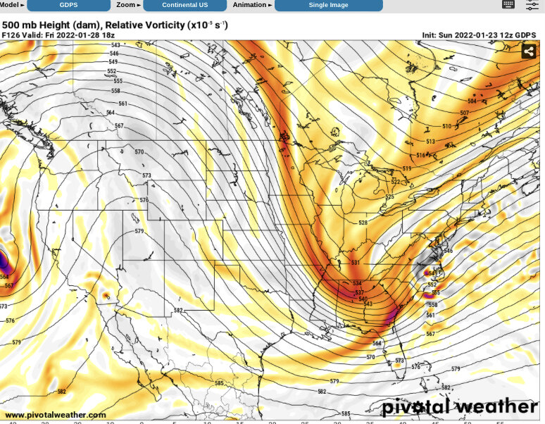
It’s so so close. We really need that ridge to not be squarely parked over the Rockies.
-
A track right over eastern NC would favor us big time. I was honestly shocked the run only dropped 7-10 inches here. A 970 low west of the OBX would be a mixed bag all the way to Burlington.
-
Light snow here now!
-
1
-
-
Flurries have commenced in eastern Burke
-
1
-
-
30/20 in eastern Burke with the cloud deck steadily lowering
-
1
-
-
Radar returns in Georgia and Alabama look very very interesting for us.
-
Well. It feels like a snow day outside. I’ve got a weird feeling we may be in for a surprise.
-
34 minutes ago, wncsnow said:
GFS.. 1.5 to 2 inches.. what a turnaround
(13).thumb.png.f13fd2a5f23f74800e39e57319995dd1.png)
Shoot at those temps, it might be more like 3
edit: this was helpful https://www.omnicalculator.com/other/rain-to-snow
-
GFS continues the march west
-
 1
1
-
-
Crazy to see these trends and it makes you wonder, how much further can it go? If we trend any more positively, suddenly we have an impactful storm tomorrow.
also shout out to @Hvwardwho called this days ago when everyone was jumping off the wagon.
-
4
-
-
We need to speak the 0z NAM from two days ago into existence
-
GFS definitely has a solid 1-2 across WNC
-
3
-
-
1 minute ago, Hvward said:
The devil is in the details with this one. Pull up a sounding, any sounding around WNC over the next 3 days and tell me that's not borderline snow. Skew-T says freezing drizzle best guess estimated precipitation with a column of air completely below freezing? Does the model not think the precipitation will push up into the dendritic growth area? Those 6000' peaks to Asheville's SW certain could help... Just because the precip maps and accumulation maps aren't showing the colors, doesn't mean that the atmosphere isn't ripe. Hell the 6z GFS has a snow sounding for tomorrow morning for most of you. The main takeaway is that the models are really struggling. They struggled like this in Dec 2017. That northern periphery of moisture was never really correctly modeled and finally it was assumed to be a nowcast event. I remember the GFS and Euro showing small stripes of snow over WNC and E TN a couple days out from the event and thinking they were warning shot. I think we are seeing something similar here, maybe on a less intense scale but today should be the day we see some type of movement in the models. I feel like we sit in a pretty good position.
That’s exactly what I needed to hear and the jolt I needed this morning. Thank you sir!
-
1
-
-
I do believe I hear a fat lady warming up her voice. I’ll hang on for one more suite but I think the writing is on the wall with this one.
@Hvwardyou’re going to have to give us some hope today!
-
3
-
-
The GFS was a solid step in the right direction
-
1
-
-
It’ll be hilarious if the globals now come in ultra suppressed
-
8 minutes ago, wncsnow said:
RGEM is decent but we miss the heaviest moisture
Luckily it’ll take less QPF than normal, even outside the mountains to produce a big one.
edit: I’d love to see the NAM with 15:1 ratios factored in
.png.d01ab529bbaf625c0a5fe5989edfc655.png)
(13).png.f0a268e6557e998262aee96884bc87ef.png)
Potential 1/28-1/30 2022 winter storm
in Southeastern States
Posted
I said it yesterday and I’ll say it again. It ain’t dead until the RGEM says it’s dead.